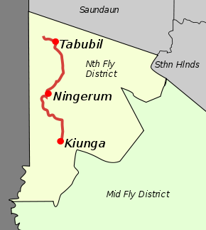
Kiunga-Tabubil Highway
| Kiunga-Tabubil Highway | |
|---|---|
 | |
| Route information | |
| Maintained by Ok Tedi Mining Limited | |
| Length | 137 km (85 mi) |
| Major junctions | |
| North end | Ok Tedi Mine, Western Province |
| South end | Kiunga, Western Province |
| Location | |
| Major cities | Tabubil, Ningerum |
| Highway system | |
| Roadways in Papua New Guinea | |
The Kiunga-Tabubil Highway is an all weather gravel road that runs from the river port town of Kiunga through Ningerum and Tabubil to the Ok Tedi Mine site, in the remote North Fly District of the Western Province of Papua New Guinea. The road is around 137 kilometres (85 mi) long, but this changes as sections are rehashed.
The "highway" was built in the early 1980s. It is maintained by Ok Tedi Mining Limited, who are the greatest beneficiaries of the road. The highway, for the most part, runs parallel with the Ok Tedi River, which, due to the fact it is a high volume waterway resting on a sand bank, is an incredibly fast moving and volatile river. Parts of the highway are often consumed by the river and need to be rebuilt. The cost of maintaining this road is K1.5 million a year, in a region where people have an average annual income of about K50 a year.
There is a copper slurry pipeline running along the full length of the road from the mine site north of Tabubil down to Bige.
The full length of the road was first cycled in 2013 by Luke Jackson, Dylan Carroll, Michael Hayen and Mikel Wolters.
