Waychinicup River
| Waychinicup River | |
|---|---|
 Waychinicup Inlet | |
| Country | Australia |
| Physical characteristics | |
| Main source |
near Manypeaks 61 metres (200 ft)[1] |
| River mouth | Southern Ocean |
| Length | 17 km (11 mi) |
| Discharge |
|
| Basin features | |
| Basin size | 145 km2 (56 sq mi) |
The Waychinicup River is located in the Great Southern region of Western Australia. The headwaters of the river are located near the town of Manypeaks along the South Coast Highway, with an elevation of approximately 100 metres (328 ft) above sea level and flows in a generally southerly direction through the Mount Manypeaks Range then through the Waychinicup National Park until it discharges into the Southern Ocean.
There is road access to the mouth of the river and it is located 65 kilometres (40 mi) from Albany, Western Australia.[3]
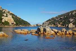
The coastal part of the river is an estuary that is 130 metres (427 ft) long and less than 2 metres (7 ft) deep,it is well flushed by tidal and swell action of the ocean.[4]
References
- ↑ "Bonzle Digital Atlas - Map of Waychinicup River, WA". 2008. Retrieved 27 November 2008.
- ↑ "South Coast Rivercare - Waychinicup River". 2007. Retrieved 8 September 2007.
- ↑ "Albany Gateway - National Parks". 2007. Archived from the original on 6 September 2007. Retrieved 8 September 2007.
- ↑ "Waychinicup Estuary, Western Australia". 2007. Retrieved 8 September 2007.
Coordinates: 34°53′25.64″S 118°19′55.16″E / 34.8904556°S 118.3319889°E
Rivers of Western Australia | |
|---|---|
| Rivers of the Gascoyne region | |
| Rivers of the Goldfields-Esperance region | |
| Rivers of the Great Southern region | |
| Rivers of the Kimberley region |
|
| Rivers of the Mid West region | |
| Rivers of the Peel and Perth regions | |
| Rivers of the Pilbara region | |
| Rivers of the South West region | |
| Rivers of the Wheatbelt region | |
| |