Canning River (Western Australia)

The Canning River (Djarlgarra in Nyungar) is a major tributary of the Swan River in south western Western Australia.
Source and route
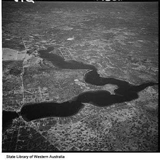
With headwaters on the Darling Scarp, the Canning meanders through suburbs of Perth on the Swan Coastal Plain, including Cannington, Thornlie, Riverton, Shelley, Rossmoyne and Mount Pleasant, before joining the Swan at Melville Water just downstream of the Canning Bridge.[1]
Bridges
- Canning Bridge
- Mount Henry Bridge
- Shelley Bridge
- Riverton Bridge
- Kent Street Weir Bridge
- Greenfield Street Bridge
- Canning River Downstream Bridge
- Canning River Upstream Bridge
- Djarlgarra Bridge Easthbound
- Djarlgarra Bridge Westbound
- unnamed railway bridge
- Royal Street Bridge
- unnamed pedestrian bridge
- Burslem Bridge
- unnamed railway bridge
- Jenna Biddi Footbridge
- unnamed railway bridge
- unnamed pedestrian bridge
- Cargeeg Bridge
- unnamed road bridge
- Manning Road Footbridge
Points
- Coffee Point (east of Point Heathcote on the Swan River)
- Deepwater Point (on western shore in Mount Pleasant)
- Salter Point (very narrow part of river between Salter Point suburb on north side, Rossmoyne/Shelley border on south)
- Prisoner Point (south shore in Shelley suburb, east of Shelley Beach)
- Wadjup Point (north west of Shelley Bridge)
History
The first European contact was in 1801[2] when a French exploring party spotted the mouth. The crew subsequently named the mouth Entrée Moreau[2] after Charles Moreau, a midshipman with the party.
The Canning River received its contemporary name in 1827 when Captain James Stirling aboard HMS Success following an examination of the region in March 1827 named the river after George Canning,[2] an eminent British statesman who was Prime Minister of Great Britain at the time and whose government facilitated the funds for the expedition.
In November 1829, just five months after the founding of the Swan River Colony in Western Australia, an exploring party led by now Governor James Stirling chose a site for a new town named Kelmscott[3] on the banks of the Canning River.
Convicts
Convicts partly constructed and maintained the Canning River Convict Fence.[4][5][6][7][8] This structure is still a notable landmark to this day. It was built primarily for the use of barges carrying timber from Mason's Timber Mill in the Darling Ranges.
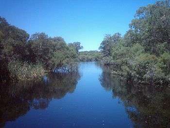
The river is home to much wildlife including dolphins, pelicans, swans and many other bird species.
Algae bloom
Algal blooms occur naturally in the Canning River system, they are caused by a buildup of nutrients in the river. Human activities including farming, residential gardens and parklands are the major causes of increases in levels, the blooms are potentially toxic to both mammal and marine life. The Swan River Trust monitors the levels of nutrients and growth of the algae issuing warnings and closing sections of the river to all activities. The Trust also operates cleanup programs to reduce the amount of nutrients reaching the river, as well phosphorus removal and oxygenation in areas were blooms have been identified.[9]
The Trust is encouraged by the appearance of Azolla carpets on sections of the Canning River as this fern is known to reduce the amount of sunlight available to the algae as well as absorbing large amounts of phosphorus and other nutrients from the water. However, it is possible that Azolla carpets can cause deoxygenation and emit a strong sulfur smell.[10]

See also
References
- ↑ "Canning Dam". About Australia. Retrieved 6 June 2009.
- 1 2 3 Western Australian Land Information Authority. "History of river names". Archived from the original on 16 February 2015. Retrieved 21 April 2013.
- ↑ "European Settlement". Archived from the original on 8 June 2009. Retrieved 6 June 2009.
- ↑ Carde, F.G. (1991) [1968]. Along the Canning: A History of the City of Canning, Western Australia, Covering its progress from Roads Board to Shire, to Town, to City (2nd ed.). City of Canning.
- ↑ McQueen, Jeanette (1963). Pioneers of the Canning District (Thesis). Graylands Teachers' College. p. 13.
- ↑ Detail from 'Municipal Heritage Inventory', City of Canning
- ↑ Hutchison, D.; Davidson, Dianne (1979). "The Convict-Built 'Fence' in the Canning River" (PDF). 8 (1). Records of the Western Australian Museum: 147–159. Retrieved 26 March 2016.
- ↑ LePage, J.S.H. (1986). Building A State: The Story of the Public Works Department of Western Australia 1829-1985. Leederville: Water Authority of Western Australia. p. 211. ISBN 978-0-7244-6862-1.
- ↑ "Algal Bloom - Swan River Trust media statement" (PDF). 16 March 2007. Archived from the original (PDF) on 11 April 2008. Retrieved 5 April 2014.
- ↑ "Native fern on Canning River - Swan River Trust media statement" (PDF). 6 March 2007. Archived from the original (PDF) on 11 April 2008. Retrieved 5 April 2014.
Further reading
- Brearley, Anne (2005). Ernest Hodgkin's Swanland : estuaries and coastal lagoons of South-western Australia. Crawley, W.A.: University of Western Australia Press for the Ernest Hodgkin Trust for Estuary Education and Research and National Trust of Australia (WA),. ISBN 1-920694-38-2.
- Burningham, Nick (2004). Messing About in Earnest. Fremantle Arts Centre Press. ISBN 1-920731-25-3.
- Richards, Oline. (199). Canning River Regional Park, Western Australia : historical survey. Perth, W.A.: Dept. of Planning and Urban Development. ISBN 0-7309-3249-4.
- Seddon, George (1970). Swan River Landscapes. Crawley, W.A.: University of Western Australia Press. ISBN 0-85564-043-X.
- Carden, F.G. (1991) [1968]. Along the Canning: A History of the City of Canning Western Australia, Covering its progress from Roads Board to Shire, to Town, to City City of Canning, (2nd ed.).
Rivers of Western Australia | |
|---|---|
| Rivers of the Gascoyne region | |
| Rivers of the Goldfields-Esperance region | |
| Rivers of the Great Southern region | |
| Rivers of the Kimberley region |
|
| Rivers of the Mid West region | |
| Rivers of the Peel and Perth regions | |
| Rivers of the Pilbara region | |
| Rivers of the South West region | |
| Rivers of the Wheatbelt region | |
| |