Waterfront station (Vancouver)
Waterfront | |||||||||||||||||||||||
|---|---|---|---|---|---|---|---|---|---|---|---|---|---|---|---|---|---|---|---|---|---|---|---|
| TransLink station | |||||||||||||||||||||||
 | |||||||||||||||||||||||
| Location |
601 West Cordova Street, Vancouver 439 Granville Street, Vancouver | ||||||||||||||||||||||
| Coordinates | 49°17′09″N 123°06′42″W / 49.28583°N 123.11167°WCoordinates: 49°17′09″N 123°06′42″W / 49.28583°N 123.11167°W | ||||||||||||||||||||||
| Owned by | Cadillac Fairview | ||||||||||||||||||||||
| Platforms | 3 separate sets of centre platforms | ||||||||||||||||||||||
| Tracks | 6 | ||||||||||||||||||||||
| Connections |
| ||||||||||||||||||||||
| Construction | |||||||||||||||||||||||
| Structure type | At-grade and underground | ||||||||||||||||||||||
| Bicycle facilities | Outside bike racks | ||||||||||||||||||||||
| Disabled access | Yes | ||||||||||||||||||||||
| Other information | |||||||||||||||||||||||
| Station code | WF | ||||||||||||||||||||||
| Fare zone | 1 | ||||||||||||||||||||||
| History | |||||||||||||||||||||||
| Opened |
| ||||||||||||||||||||||
| Traffic | |||||||||||||||||||||||
| Passengers (2017[1]) | 37,500 (Expo and Canada Lines) | ||||||||||||||||||||||
| Services | |||||||||||||||||||||||
| |||||||||||||||||||||||
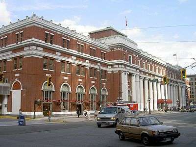
Waterfront is a major intermodal public transportation facility and the main transit terminus in Vancouver, British Columbia, Canada. It is located on West Cordova Street in Downtown Vancouver, between Granville and Seymour Street. The station is also accessible via two other street-level entrances, one on Howe Street to the west for direct access to the Expo Line and another on Granville Street to the south for direct access to the Canada Line.
The station is within walking distance of Vancouver's historical Gastown district, Canada Place, Convention & Exhibition Centre, Harbour Centre, Sinclair Centre, and the Vancouver Harbour Flight Centre float plane terminal. A heliport operated by Helijet, along with the downtown campuses for Simon Fraser University and the British Columbia Institute of Technology, are also located within the vicinity of the station.
History

Waterfront station was built by the Canadian Pacific Railway (CPR) and opened on August 1, 1914.[2] It was the Pacific terminus for the CPR's transcontinental passenger trains to Montreal, Quebec and Toronto, Ontario. The current station is the third CPR station. The previous CPR station was located one block west, at the foot of Granville, and unlike the current classical-styled Waterfront station was built in "railway gothic" like the CPR's many railway hotels.[3][4]
In 1978, when Via Rail took over the passenger operations of the CPR and the Canadian National Railway, it continued using both railways' stations in Vancouver, but a year later, Via consolidated its Vancouver operations at Pacific Central Station, the CN station near False Creek, and ceased using the CPR station. The last scheduled Via passenger train to use Waterfront station departed on October 27, 1979.[2]
Waterfront station's transformation into a public intermodal transit facility began in 1977. That year, the SeaBus began operating out of a purpose-built floating pier that was connected to the main terminal building via an overhead walkway above the CPR tracks. The CPR's passenger platform and some of its tracks were torn up in the early 1980s to make way for the guideway of the original SkyTrain line (Expo Line), which opened on December 11, 1985. During Expo 86, SkyTrain operated special shuttle trains between Waterfront station and Stadium–Chinatown station (then named Stadium station), connecting the Canadian Pavilion at Canada Place to the main Expo site along False Creek.
A private ferry company, Royal SeaLink Express, ran passenger ferries from a new dock on the west side of the SeaBus terminal to Victoria and Nanaimo in the early 1990s, but ultimately folded. In 2003, HarbourLynx began operating out of Royal Sealink's old facility at the SeaBus terminal. In 2006, following major engine problems with their only vessel, they folded as well.
In 1995, platforms were built adjacent to the SkyTrain station for the West Coast Express, which uses the existing CPR tracks. The platforms for the West Coast Express were built in the same location as the old CPR platforms. Starting in 2002 and continuing until late 2016, Millennium Line trains shared the SkyTrain tracks with the Expo Line.[5] In 2009, the Canada Line opened with separate platforms which were accessible via the station. Waterfront station serves as a common terminus point for both the Expo Line and the Canada Line.
Waterfront station was one of the first to receive TransLink's new "T" signage, denoting a transit station.[6] This signage was installed in the downtown core of Vancouver to help visitors during the 2010 Olympics to identify a transit hub.
Architecture


The main station building was designed in a neoclassical style, with a symmetrical red-brick facade dominated by a row of smooth, white Ionic order columns. The Ionic columns are repeated in the grand interior hall, flanking the perimeter of the space. The main hall features two large clocks facing each other high on the east and west walls. Paintings depicting various scenic Canadian landscapes, completed in 1916 by Adelaide Langford, line the walls above the columns.
Services
- SkyTrain Expo Line through Vancouver to Northeast/South Burnaby, New Westminster and Surrey.
- SkyTrain Canada Line, through Vancouver to central Richmond and Vancouver International Airport.
- West Coast Express commuter rail and TrainBus to Port Moody, Coquitlam, Port Coquitlam, Pitt Meadows, Maple Ridge, and Mission.
- SeaBus passenger ferry to Lonsdale Quay in North Vancouver.
- Various local, suburban, and express bus services provided by TransLink.
- HeliJet's heliport is adjacent to the SeaBus concourse, therefore allowing passengers to connect to Waterfront station's main terminal building.
- Vancouver Harbour Flight Centre float plane terminal is located approximately two blocks west of Canada Place.
Station information

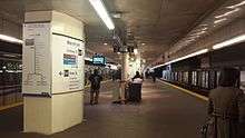


Station layout
| S | Street | Cordova Street, Howe Street, Granville Street entrances |
| Concourse (Cordova) |
Main connection points between various modes of transportation Compass ticketing machines, ATM, shops, fare gates (Expo Line) | |
| C | Concourse (Howe) |
Serving Expo Line Connections to Sinclair Centre and Waterfront Center Compass ticketing machines, fare gates (Expo Line) |
| Concourse (Granville) |
Serving Canada Line Compass ticketing machines, shops, fare gates (Canada Line) | |
| T | Platform 1 |
← ■ Expo Line termination track |
| Island platform; doors will open on the left | ||
| Platform 2 Outbound |
■ Expo Line towards King George and Production Way–University (Burrard) → | |
| ■ West Coast Express towards Mission City (Moody Centre) → | ||
| Island platform; doors will open on the left, right | ||
| ■ West Coast Express towards Mission City (Moody Centre) → | ||
| Lower Concourse (Cordova) |
Compass ticketing machines, fare gates (Canada Line) | |
| Platform 3 Outbound |
■ Canada Line towards Richmond–Brighouse and YVR–Airport (Vancouver City Centre) → | |
| Island platform; doors will open on the left, right | ||
| Platform 4 Outbound |
■ Canada Line towards Richmond–Brighouse and YVR–Airport (Vancouver City Centre) → | |
| Lower Concourse (SeaBus) |
Fare gates (Helipad Exit), washrooms Connection to HeliJet heliport | |
| Unused | ||
| Island platform; doors will open on the right | ||
| ■ SeaBus outbound towards Lonsdale Quay (Terminus) | ||
| Island platform; doors will open on the left, right | ||
| ■ SeaBus outbound towards Lonsdale Quay (Terminus) | ||
| Island platform; doors will open on the left | ||
| Unused | ||
Entrances
- Cordova Street entrance (terminal building)

- Howe Street entrance: serves Canada Place, with underground connection to Sinclair Centre and Waterfront Centre at concourse level. No elevator is available at this entrance.
- Granville Street entrance
Transit connections
- Bus service on West Cordova Street, in front of the terminal building (Cordova entrance):
- 44 UBC
- 50 False Creek South
- Bus service at nearby intersection of Cordova Street and Seymour Street across from the entrance:
- 3 Main
- 4 Powell
- 7 Nanaimo Station
- 8 Fraser
- 10 Downtown
- 50 Waterfront Station
- N8 Fraser
- Bus service on Hastings Street, north of the Granville Street entrance:
- 95 Burrard Station / SFU B-Line
- Bus service on Pender Street, south of the Granville Street entrance:
- 4 UBC
- 5 Robson
- 7 Dunbar
- 10 Granville
- 17 Oak
- 19 Stanley Park / Metrotown Station
- 22 Knight
- 209 Upper Lynn Valley (evening only)
- 210 Upper Lynn Valley
- 211 Seymour
- 214 Blueridge (PM peak only)
- N19 Downtown
- N22 Downtown
- N24 Downtown
- Additional service available on Granville Street:
- 4 Powell
- 7 Nanaimo Station
- 10 Downtown/Granville
- 14 UBC/Hastings
- 16 Arbutus / 29th Avenue Station
- 17 Oak
- 20 Victoria
- 50 Waterfront Station / False Creek South
See also
References
- ↑ "2017 Transit Service Performance Review" (PDF). translink.ca. TransLink. Retrieved June 28, 2018.
- 1 2 "By the Numbers: Waterfront Station turns 100". The Province. July 31, 2014. Retrieved April 3, 2018.
- ↑ Photograph of CPR Station, foot of Granville, 1906, British Columbia Archives.
- ↑ CPR station, undated photograph, British Columbia Archives, at Columbia Pacific.
- ↑ "Translink introduces new SkyTrain operating pattern on October 22". Translink. September 19, 2016. Retrieved November 5, 2016.
- ↑ "More T signage is now up in downtown Vancouver", The Buzzer Blog, TransLink, January 27, 2010.
External links
![]()
| |||||||||||||
| |||||||||||||
| |||||||||||||
Landmarks in Greater Vancouver | ||
|---|---|---|
| Buildings |
|  |
| Bridges |
| |
| Locations | ||
| Geographical | ||
| ||