Skybridge (TransLink)
| SkyBridge | |
|---|---|
 | |
| Coordinates | 49°12′20″N 122°53′48″W / 49.20556°N 122.89667°W |
| Carries | Two tracks of the Expo Line and a maintenance track |
| Crosses | Fraser River |
| Locale |
New Westminster Surrey |
| Characteristics | |
| Total length | 616 metres (2,021 ft) |
| Height | 123 metres (404 ft) |
| Longest span | 340 metres (1,115 ft) |
| Clearance below | 45 metres (148 ft) |
| History | |
| Opened | March 16, 1990 |

The SkyBridge is a cable-stayed bridge in Metro Vancouver, British Columbia, Canada. Built between 1987 and 1989, it spans the Fraser River and connects New Westminster with Surrey.[1] The SkyBridge opened for revenue use on March 16, 1990 with the second half of the Phase II extension of SkyTrain to Scott Road Station.
History
Construction of the bridge began on October 28, 1987.[2] The first half of the bridge heading towards Surrey was completed first, with the New Westminster half being completed on March 19, 1990.[2] The bridge was manufactured by Hyundai Engineering & Construction and a Chilliwack-based construction company with a total cost of CAD$28 million,[2] or $53.3 million in 2017 dollars.[3]
Details
The SkyBridge does not carry automobiles, unlike the neighbouring Pattullo Bridge, but has two tracks to let the TransLink SkyTrain to pass either way on the bridge on its journey between King George Station in Surrey and Waterfront Station in Downtown Vancouver. A third set of rails in the middle, not connected to the SkyTrain tracks, is used by maintenance crews to truck equipment back and forth on the bridge.
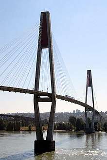
The bridge has two 123-metre (404 ft) tall towers and carries trains 45 metres (148 ft) above the Fraser River and valley.[4] The main span is 340 metres (1,120 ft) and the total length is 616 metres (2,021 ft), making it the longest cable-supported transit-only bridge in the world.[5]
Gallery
.jpg) A view of the SkyBridge from a SkyTrain in 2011
A view of the SkyBridge from a SkyTrain in 2011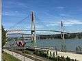 View of SkyBridge from New Westminster in 2016
See also
Notes
- ↑ "SkyTrain & SkyBridge" (PDF). New Westminster Parks, Culture & Recreation. Retrieved August 9, 2014.
- 1 2 3 "Heritage Database". New Westminster Heritage. New Westminster Public Library. Retrieved August 9, 2014.
- ↑ Canadian inflation numbers based on Statistics Canada. "Consumer Price Index, historical summary". Statistics Canada. Retrieved April 26, 2018. CANSIM, table (for fee) 326-0021 and Catalogue nos. 62-001-X, 62-010-X and 62-557-X. And "Consumer Price Index, by province (monthly) (Canada)". Statistics Canada. Retrieved April 26, 2018.
- ↑ "Vancouver SkyTrain, Canada". railway-technology. Retrieved August 9, 2014.
- ↑ "Skytrain Bridge". Buckland & Taylor Ltd. Retrieved November 2, 2013.
References
External links
| Wikimedia Commons has media related to SkyBridge (TransLink). |
Coordinates: 49°12′20″N 122°53′49″W / 49.205465°N 122.896993°W