Washington Township, Crawford County, Kansas
| Washington Township | |
|---|---|
| Township | |
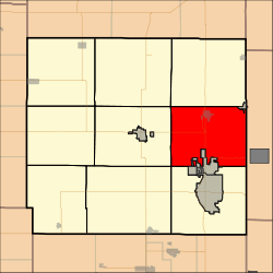 Location in Crawford County | |
| Coordinates: 37°31′09″N 094°41′21″W / 37.51917°N 94.68917°WCoordinates: 37°31′09″N 094°41′21″W / 37.51917°N 94.68917°W | |
| Country | United States |
| State | Kansas |
| County | Crawford |
| Area | |
| • Total | 60.2 sq mi (155.92 km2) |
| • Land | 59.62 sq mi (154.43 km2) |
| • Water | 0.58 sq mi (1.49 km2) 0.96% |
| Elevation | 961 ft (293 m) |
| Population (2010) | |
| • Total | 3,501 |
| • Density | 58/sq mi (22/km2) |
| GNIS feature ID | 0469733 |
Washington Township is a township in Crawford County, Kansas, United States. As of the 2010 census, its population was 3,501.[1]
Geography
Washington Township covers an area of 60.2 square miles (156 km2) and contains two incorporated settlements, Arma, and the larger Frontenac. According to the USGS, it contains five cemeteries: Frontenac City Cemetery located within the City of Frontenac; Sacred Heart Catholic Cemetery, also located within the Frontenac city limits; Garden of Memories, located 3 miles north of Frontenac on US 69 Hwy; Lone Star, Rosebank, Smilie and Union Center all located in rural areas.
Transportation
Washington Township contains two airports or landing strips: Galichia Airport and Youvan Airport.
References
- ↑ "Race, Hispanic or Latino, Age, and Housing Occupancy: 2010 Census Redistricting Data (Public Law 94-171) Summary File (QT-PL), Washington township, Crawford County, Kansas". U.S. Census Bureau, American FactFinder 2. Retrieved October 28, 2011.
External links
Municipalities and communities of Crawford County, Kansas, United States | ||
|---|---|---|
| Cities | 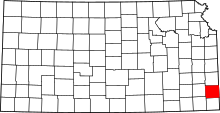 | |
| Townships | ||
| CDPs | ||
| Unincorporated communities | ||
| Footnotes | ‡This populated place also has portions in an adjacent county or counties | |
This article is issued from
Wikipedia.
The text is licensed under Creative Commons - Attribution - Sharealike.
Additional terms may apply for the media files.