Arma, Kansas
| Arma, Kansas | |
|---|---|
| City | |
 Location within Crawford County and Kansas | |
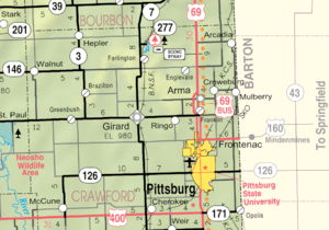 KDOT map of Crawford County (legend) | |
| Coordinates: 37°32′37″N 94°42′2″W / 37.54361°N 94.70056°WCoordinates: 37°32′37″N 94°42′2″W / 37.54361°N 94.70056°W | |
| Country | United States |
| State | Kansas |
| County | Crawford |
| Area[1] | |
| • Total | 1.14 sq mi (2.95 km2) |
| • Land | 1.12 sq mi (2.90 km2) |
| • Water | 0.02 sq mi (0.05 km2) |
| Elevation | 1,014 ft (309 m) |
| Population (2010)[2] | |
| • Total | 1,481 |
| • Estimate (2016)[3] | 1,444 |
| • Density | 1,300/sq mi (500/km2) |
| Time zone | UTC-6 (Central (CST)) |
| • Summer (DST) | UTC-5 (CDT) |
| ZIP code | 66712 |
| Area code(s) | 620 |
| FIPS code | 20-02375 [4] |
| GNIS ID | 0475148 [5] |
Arma is a city in Crawford County, Kansas, United States. According to the 2010 census, the city's population was 1,481.[6]
History
Arma was founded in 1894.[7] It was named for W.F. Armacost, an original landowner.[8]
A post office was opened at Arma in 1891, and remained in operation until it was discontinued in 1906.[9]
Arma was a station on the Missouri Pacific Railroad.[10]
Geography
Arma is located at 37°32′37″N 94°42′2″W / 37.54361°N 94.70056°W (37.543679, −94.700472).[11] According to the United States Census Bureau, the city has a total area of 1.14 square miles (2.95 km2), of which, 1.12 square miles (2.90 km2) is land and 0.02 square miles (0.05 km2) is water.[1] It is located about 6 minutes' drive north of Frontenac, and about 8 minutes' drive east of Girard.
Demographics
2010 census
| Historical population | |||
|---|---|---|---|
| Census | Pop. | %± | |
| 1910 | 327 | — | |
| 1920 | 2,180 | 566.7% | |
| 1930 | 2,004 | −8.1% | |
| 1940 | 1,615 | −19.4% | |
| 1950 | 1,334 | −17.4% | |
| 1960 | 1,296 | −2.8% | |
| 1970 | 1,348 | 4.0% | |
| 1980 | 1,676 | 24.3% | |
| 1990 | 1,542 | −8.0% | |
| 2000 | 1,529 | −0.8% | |
| 2010 | 1,481 | −3.1% | |
| Est. 2016 | 1,444 | [3] | −2.5% |
| U.S. Decennial Census | |||
As of the census[2] of 2010, there were 1,481 people, 657 households, and 372 families residing in the city. The population density was 1,322.3 inhabitants per square mile (510.5/km2). There were 736 housing units at an average density of 657.1 per square mile (253.7/km2). The racial makeup of the city was 97.0% White, 0.1% African American, 1.4% Native American, 0.1% Asian, 0.5% from other races, and 1.0% from two or more races. Hispanic or Latino of any race were 2.7% of the population.
Of the city' 657 households 27.2% had children under the age of 18 living with them, 41.7% were married couples living together, 11.1% had a female householder with no husband present, 3.8% had a male householder with no wife present, and 43.4% were non-families. 38.1% of all households were made up of individuals and 14.8% had someone living alone who was 65 years of age or older. The average household size was 2.20 and the average family size was 2.93.
The median age in the city was 42.1 years. 22.4% of residents were under the age of 18; 7.8% were between the ages of 18 and 24; 23.5% were from 25 to 44; 27.8% were from 45 to 64; and 18.3% were 65 years of age or older. The gender makeup of the city was 48.1% male and 51.9% female.
2000 census
There were 669 households out of which 26.8% had children under the age of 18 living with them, 49.0% were married couples living together, 6.7% had a female householder with no husband present, and 40.4% were non-families. 37.1% of all households were made up of individuals and 19.7% had someone living alone who was 65 years of age or older. The average household size was 2.20 and the average family size was 2.91.
In the city, the population was spread out with 21.4% under the age of 18, 7.9% from 18 to 24, 25.2% from 25 to 44, 22.4% from 45 to 64, and 23.1% who were 65 years of age or older. The median age was 42 years. For every 100 females, there were 88.3 males. For every 100 females age 18 and over, there were 87.8 males.
The median income for a household in the city was $26,658, and the median income for a family was $36,648. Males had a median income of $27,337 versus $19,821 for females. The per capita income for the city was $15,636. About 8.4% of families and 11.9% of the population were below the poverty line, including 14.4% of those under age 18 and 15.8% of those age 65 or over.
Education
Arma is served by USD 246 Northeast.[12]
Prior to school unification, the Arma High School mascot was Bulldogs.[13] The Arma Bulldgos won the Kansas State High School boys class B Track & Field championship in 1952.[14]
Area events
V-J celebration
Arma's V-J Homecoming celebration is believed to be the oldest running V-J Day or World War II celebration in the country. Held annually the second weekend of August, Arma's V-J Homecoming Celebration started in 1946 as a way to honor local veterans returning home from World War II, and has evolved into a family festival. The original V-J Day was August 15, 1945, the day the Victory Over Japan was celebrated by the Allied Nations. On September 2, 1945, the Japanese signed the official surrender document. That Labor Day weekend marked the end of nearly four years of devastation, loss and sacrifice for the nation. More than 300,000 Americans in the armed services died in Europe and the Pacific arenas. The very next year, Arma celebrated its VJ Day in connection with homecoming activities, and the V-J Homecoming Celebration was born.[15]
Area attractions
Arma Veterans Memorial
Following World War II, the American Legion in Arma wanted to honor local veterans. The Arma Veterans Memorial was built on the southeast corner of Arma City Park. Constructed shortly after the war, the City of Arma did the construction, maintains and adds new names to the memorial. Names on the plaque represent local veterans who have served the U.S. in any war. Recently, the American Flag was added along with flags for the Army, Navy, Air Force, and Marines.[16]
Carved statues at City Park
Several wood carvings by chain saw artist, Ed Babcock, are on display at the Arma City Park.[17]
References
- 1 2 "US Gazetteer files 2010". United States Census Bureau. Archived from the original on January 24, 2012. Retrieved July 6, 2012.
- 1 2 "American FactFinder". United States Census Bureau. Retrieved July 6, 2012.
- 1 2 "Population and Housing Unit Estimates". Retrieved June 9, 2017.
- ↑ "American FactFinder". United States Census Bureau. Archived from the original on 2013-09-11. Retrieved 2008-01-31.
- ↑ "US Board on Geographic Names". United States Geological Survey. 2007-10-25. Retrieved 2008-01-31.
- ↑ "2010 City Population and Housing Occupancy Status". U.S. Census Bureau. Archived from the original on July 26, 2011. Retrieved April 10, 2012.
- ↑ Kansas State Historical Society (1916). Biennial Report of the Board of Directors of the Kansas State Historical Society. Kansas State Printing Plant. p. 171.
- ↑ "Profile for Arma, Kansas". ePodunk. Retrieved 8 June 2014.
- ↑ "Kansas Post Offices, 1828-1961 (archived)". Kansas Historical Society. Archived from the original on October 9, 2013. Retrieved 6 June 2014.
- ↑ Blackmar, Frank Wilson (1912). Kansas: A Cyclopedia of State History, Embracing Events, Institutions, Industries, Counties, Cities, Towns, Prominent Persons, Etc. Standard Publishing Company. p. 101.
- ↑ "US Gazetteer files: 2010, 2000, and 1990". United States Census Bureau. 2011-02-12. Retrieved 2011-04-23.
- ↑ "High School". USD 246. Retrieved 6 January 2017.
- ↑ "Northeast High School Alumni". classmates. Retrieved 10 January 2017.
- ↑ "Track & Field". KSHSAA. Retrieved 6 January 2017.
- ↑ "VJ Homecoming". City of Arma, Kansas. Retrieved 12 June 2018.
- ↑ "VJ Homecoming". City of Arma, Kansas. Retrieved 13 June 2018.
- ↑ "VJ Homecoming". City of Arma, Kansas. Retrieved 13 June 2018.
External links
- City
- Schools
- USD 246, local school district
- Maps
- Arma City Map, KDOT
Municipalities and communities of Crawford County, Kansas, United States | ||
|---|---|---|
| Cities | 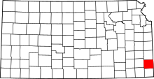 | |
| Townships | ||
| CDPs | ||
| Unincorporated communities | ||
| Footnotes | ‡This populated place also has portions in an adjacent county or counties | |