Auglaize River
| Auglaize River | |
|---|---|
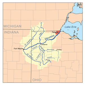 Map of the Maumee River watershed showing the Auglaize River. | |
| Physical characteristics | |
| Main source |
2 mi (3.2 km) south of Harrod ~ 990 ft (300 m)[1] |
| River mouth |
Maumee River at Defiance ~ 665 ft (203 m)[2] |
| Length | 113 miles (182 km)[3] |
| Basin features | |
| Basin size | 2,337 sq mi (6,050 km2)[4] |
The Auglaize River (Shawnee: Kathinakithiipi)[5] is a 113-mile-long (182 km)[3] tributary of the Maumee River in northwestern Ohio in the United States. It drains a primarily rural farming area in the watershed of Lake Erie. The name of the river comes from the French word for glaise (clay). The French called it "rivière à la Grande Glaize" (river of Great Clay)[6].
It rises in southeastern Allen County, approximately 10 miles (16 km) southeast of Lima and 12 miles (19 km) north of Indian Lake. It flows southwest to Wapakoneta, then generally north in a zigzag course, past Delphos, Fort Jennings and Oakwood. It joins the Maumee from the south at Defiance, approximately 2 miles (3 km) east of the mouth of the Tiffin River at 41°17′13″N 84°21′23″W / 41.286893°N 84.356527°W.
It receives the Ottawa River from the southeast in western Putnam County, northwest of Lima. It also receives the Blanchard River in western Putnam County. It receives the Little Auglaize River from the south in eastern Paulding County. It receives Flatrock Creek from the west in northeastern Paulding County.
During the days of the Ohio Country in the 18th century, the area around the river was inhabited by the Ottawa. Fort Amanda, constructed along the river southwest of Lima in 1812, was an important American outpost during the War of 1812. Fort Defiance was constructed in 1794 near the confluence of the Auglaize and the Maumee by General Mad Anthony Wayne.
Variant names
According to the Geographic Names Information System, the Auglaize River has also been known as:[7]
- Au Glaize River
- Auglaise River
- Cowthenake sepe
- Glaize River
- Grand Au Glaze River
- Grand Glaise River
- Grand Glaize River
- Great au Glaise River
- Qusquasrundee
See also
- List of rivers of Ohio
- Grandglaize Creek, tributary of the Lake of the Ozarks which is also uses the Auglaize name
References
- ↑ U.S. Geological Survey. Harrod quadrangle, Ohio. 1:24,000. 7.5 Minute Series. Washington D.C.: USGS, 1961.
- ↑ U.S. Geological Survey. Defiance East quadrangle, Ohio. 1:24,000. 7.5 Minute Series. Washington D.C.: USGS, 1988.
- 1 2 U.S. Geological Survey. National Hydrography Dataset high-resolution flowline data. The National Map Archived 2012-04-05 at WebCite, accessed May 19, 2011
- ↑ A Guide to Ohio Streams. Archived September 4, 2005, at the Wayback Machine. Chapter 10: Major Ohio Watersheds (pdf) Archived September 4, 2005, at the Wayback Machine.
- ↑ "Shawnees Webpage". Shawnee's Reservation. 1997. Retrieved 2013-04-26.
- ↑ See, for example, French Colonial Archives, series C11A, vol. 95, f. 386v. http://data2.archives.ca/e/e035/e000869161.jpg
- ↑ U.S. Geological Survey Geographic Names Information System: Auglaize River
External links
| Wikimedia Commons has media related to Auglaize River. |