Wanzhou District
| Wanzhou 万州区 | |
|---|---|
| District | |
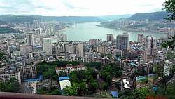 The Yangtze River / Three Gorges reservoir at Wanzhou | |
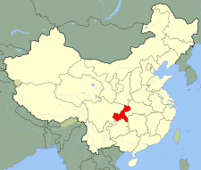
 Wanzhou District in Chongqing | |
| Coordinates: 30°48′28″N 108°24′32″E / 30.807819°N 108.408751°E | |
| Country | People's Republic of China |
| Municipality | Chongqing |
| Area | |
| • District | 3,457 km2 (1,335 sq mi) |
| • Urban | 80 km2 (30 sq mi) |
| Population (2013) | |
| • District | 1,753,500 |
| • Density | 510/km2 (1,300/sq mi) |
| • Urban (2018)[1] | 700,000 |
| Time zone | UTC+8 (China Standard) |
| GDP | 2013 |
| - Total |
CNY 70.23 billion (US$ 11.46 billion) |
| - Per capita |
CNY 43,197 (US$ 7,047) |
| Licence plate prefix | 渝F |
| Website |
wz |
Wanzhou District (simplified Chinese: 万州区; traditional Chinese: 萬州區; pinyin: Wànzhōu Qū) is Chongqing's second most populated urban core area on the upper reaches of the Three Gorges of the Yangtze River in China. It is currently governed as a district of Chongqing Municipality, bordering Sichuan to the northwest and Hubei to the southeast. It was formerly known as Wanxian or Wan County (simplified Chinese: 万县; traditional Chinese: 萬縣; pinyin: Wànxiàn). Prior to Chongqing's formation as a direct-controlled municipality, Wanzhou was part of Sichuan province. The urban core of Wanzhou is 228 km (142 mi) away from Chongqing's city proper.
"Wanzhou" literally means "myriad-prefecture", where "a myriad rivers converge and a myriad traders gather" (万川毕汇、万商云集). Due to the construction of the Three Gorges Dam, 47% of Wanzhou's old urban area will be underwater by the time the reservoir is filled. Buildings in the submerged area have been torn down and new ones rebuilt on higher ground.
History
The district was part of Wanxian Prefecture (万县地区), then the prefectural Wanxian City (万县市). It was renamed to Wanzhou in late 1990s.
It was part of Quren District of Ba Prefecture (巴郡朐忍县) in the Qin Dynasty. It became Yangqu District (羊渠县) in 216 (the Eastern Han Dynasty). In 230 (the Shu-Han Kingdom), it was renamed to Nanpu (南浦县); in 553 (the Western Wei dynasty), to Yuquan (鱼泉县); in 557 (Northern Zhou Dynasty), to Anxiang (安乡县); in 584, to Wanchuan (万川县); and in 598 (Sui Dynasty), to Nanchang again.
It continued to be renamed and administrated with slight differences. In the 19th century, it was known in English as Wanhsien and Wan County In 1935, it became Wanxian Zhuanqu (万县专区). On December 12, 1992, the State Council abolished Wanxian Prefecture and its subordinate Wanxian City and created the prefecture-level Wanxian City, which administered the districts of Longbao (龙宝区), Tiancheng (天城区), Wuqiao (五桥区) and the counties of Kai, Zhong, Liangping, Yunyang, Fengjie, Wushan, Wuxi, and Chengkou.
The entire Wanxian City was merged into Chongqing on December 20, 1997. The merge necessitated the abolishment of Wanxian City and creation of Wanxian District and Wanxian Migration Development Area (移民开发区). Wanxian City's three districts were converted to administrative committees (管理委员会, abbreviated 管委会) of Wanxian District. The migration development area included the counties formerly in Wanxian City, except Liangping and Chengkou, which were administered by Chongqing directly.
On May 22, 1998, the State Council approved that the two areas named Wanxian were both renamed to Wanzhou. The migration development area later dissolved and its counties were directly controlled by Chongqing. On July 19, 2000, the district's administrative committees were changed to migration development areas.
Geography and climate
Wanzhou spans 30°24′−31°14′ N latitude and 107°55′−108°53′ E longitude, and is situated at the eastern edge of the Sichuan Basin. It reaches a maximal north-south extent of 67.25 km (41.79 mi) and east-west width of 97.25 km (60.43 mi), covering an area of 3,214 km2 (1,241 sq mi). Elevations range from 106 m (348 ft) in the town of Tailong (太龙镇) to 1,762 m (5,781 ft) at Shaping Peak (沙坪峰) of the Qiyao Mountains (齐曜山).[2] Bordering county-level divisions:
- Yunyang County – east
- Shizhu County – south
- Lichuan, Hubei – south
- Zhong County – west
- Liangping County – west
- Kaijiang County, Sichuan – north
- Kai County – north
Similar to the city proper of Chongqing, Wanzhou has a monsoon-humid subtropical climate (Köppen Cwa) with short, mild winters, and very hot, humid summers, and is in fact on average 0.5 °C (0.9 °F) warmer during the day. The monthly 24-hour average temperature ranges from 7.0 °C (44.6 °F) in January to 28.3 °C (82.9 °F) in August, while the annual mean is 17.95 °C (64.3 °F).
| Climate data for Wanzhou District (1971−2000) | |||||||||||||
|---|---|---|---|---|---|---|---|---|---|---|---|---|---|
| Month | Jan | Feb | Mar | Apr | May | Jun | Jul | Aug | Sep | Oct | Nov | Dec | Year |
| Record high °C (°F) | 20.3 (68.5) |
24.6 (76.3) |
32.5 (90.5) |
36.5 (97.7) |
39.5 (103.1) |
38.6 (101.5) |
40.6 (105.1) |
42.1 (107.8) |
41.2 (106.2) |
35.8 (96.4) |
28.2 (82.8) |
19.5 (67.1) |
42.1 (107.8) |
| Average high °C (°F) | 10.4 (50.7) |
12.8 (55) |
17.4 (63.3) |
23.2 (73.8) |
27.4 (81.3) |
29.8 (85.6) |
33.4 (92.1) |
34.3 (93.7) |
28.7 (83.7) |
22.9 (73.2) |
17.6 (63.7) |
12.0 (53.6) |
22.5 (72.5) |
| Daily mean °C (°F) | 7.0 (44.6) |
8.7 (47.7) |
12.8 (55) |
18.1 (64.6) |
22.4 (72.3) |
25.2 (77.4) |
28.1 (82.6) |
28.3 (82.9) |
23.8 (74.8) |
18.6 (65.5) |
13.6 (56.5) |
8.8 (47.8) |
18.0 (64.4) |
| Average low °C (°F) | 4.5 (40.1) |
5.8 (42.4) |
9.4 (48.9) |
14.4 (57.9) |
18.8 (65.8) |
21.8 (71.2) |
24.3 (75.7) |
24.2 (75.6) |
20.6 (69.1) |
15.8 (60.4) |
11.0 (51.8) |
6.6 (43.9) |
14.8 (58.6) |
| Record low °C (°F) | −3.4 (25.9) |
−1.7 (28.9) |
−0.1 (31.8) |
2.6 (36.7) |
11.2 (52.2) |
15.4 (59.7) |
17.6 (63.7) |
18.1 (64.6) |
13.4 (56.1) |
5.3 (41.5) |
0.8 (33.4) |
−3.7 (25.3) |
−3.7 (25.3) |
| Average precipitation mm (inches) | 15.5 (0.61) |
17.1 (0.673) |
43.2 (1.701) |
101.9 (4.012) |
170.9 (6.728) |
210.5 (8.287) |
200.3 (7.886) |
146.8 (5.78) |
154.1 (6.067) |
104.6 (4.118) |
45.5 (1.791) |
18.6 (0.732) |
1,229 (48.385) |
| Average precipitation days (≥ 0.1 mm) | 7.7 | 7.7 | 11.2 | 14.6 | 15.6 | 15.2 | 12.7 | 10.9 | 12.9 | 13.7 | 10.3 | 8.5 | 141.0 |
| Source: Weather China | |||||||||||||
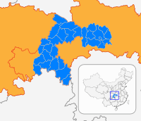
Subdivisions
The 4 primary subdivisions were 3 migration development areas (Longbao, Tiancheng, Wuqiao) and Jiangnan New District (江南新区). Now Wanzhou is subdivided into 92 township divisions are 16 sub-districts, 33 towns, and 43 townships (see Administrative divisions of the People's Republic of China#Levels). In 2000, the district included 32 towns, 45 townships, 14 sub-districts, and 1277 neighborhood and village committees.
| Name | Chinese (S) | Hanyu Pinyin | Population (2010)[3] | Area (km2) |
|---|---|---|---|---|
| Gaosuntang Subdistrict | 高笋塘街道 | Gāosǔntáng Jiēdào | 103,982 | 3 |
| Taibai Subdistrict | 太白街道 | Tàibái Jiēdào | 108,387 | 13.1 |
| Pailou Subdistrict | 牌楼街道 | Páilóu Jiēdào | 104,351 | 9.8 |
| Shuanghekou Subdistrict | 双河口街道 | Shuānghékǒu Jiēdào | 33,715 | 23 |
| Longdu Subdistrict | 龙都街道 | Lóngdōu Jiēdào | 36,134 | 24 |
| Zhoujiaba Subdistrict | 周家坝街道 | Zhōujiābà Jiēdào | 88,494 | 12 |
| Shahe Subdistrict | 沙河街道 | Shāhé Jiēdào | 24,915 | 11.2 |
| Zhonggulou Subdistrict | 钟鼓楼街道 | Zhōnggǔlóu Jiēdào | 85,873 | 38.7 |
| Bai'anba Subdistrict | 百安坝街道 | Bǎi'ānbà Jiēdào | 91,947 | 15.8 |
| Wuqiao Subdistrict | 五桥街道 | Wǔqiáo Jiēdào | 20,672 | 25.7 |
| Chenjiaba Subdistrict | 陈家坝街道 | Chénjiābà Jiēdào | 24,745 | 34.75 |
| Xiaozhou town | 小周镇 | Xiǎozhōu Zhèn | 9,136 | 49 |
| Dazhou town | 大周镇 | Dàzhōu Zhèn | 12,184 | 64 |
| Xinxiang town | 新乡镇 | Xīnxiāng Zhèn | 6,683 | 140.2 |
| Sunjia town | 孙家镇 | Sūnjiā Zhèn | 9,737 | 46.6 |
| Gaofeng town | 高峰镇 | Gāofēng Zhèn | 19,550 | 46.2 |
| Longsha town | 龙沙镇 | Lóngshā Zhèn | 28,127 | 25 |
| Xiangshui town | 响水镇 | Xiǎngshuǐ Zhèn | 16,889 | 59.5 |
| Wuling town | 武陵镇 | Wǔlíng Zhèn | 24,632 | 34.4 |
| Rangdu town | 瀼渡镇 | Ràngdù Zhèn[4] | 11,613 | 30.7 |
| Ganning town | 甘宁镇 | Gānníng Zhèn | 30,873 | 104.8 |
| Tiancheng town | 天城镇 | Tiānchéng Zhèn | 41,762 | 52.4 |
| Xiongjia town | 熊家镇 | Xióngjiā Zhèn | 33,176 | 82.5 |
| Gaoliang town | 高梁镇 | Gāoliáng Zhèn | 49,357 | 37.7 |
| Lihe town | 李河镇 | Lǐhé Zhèn | 23,264 | 38.7 |
| Fenshui town | 分水镇 | Fēnshuǐ Zhèn | 60,308 | 220.96 |
| Yujia town | 余家镇 | Yújiā Zhèn | 30,454 | 78.2 |
| Houshan town | 后山镇 | Hòushān Zhèn | 15,338 | 78.86 |
| Danzi town | 弹子镇 | Dànzǐ Zhèn | 18,318 | 54.6 |
| Changling town | 长岭镇 | Zhǎnglǐng Zhèn | 34,962 | 53.2 |
| Xintian town | 新田镇 | Xīntián Zhèn | 34,145 | 104.4 |
| Baiyang town | 白羊镇 | Báiyáng Zhèn | 38,078 | 34.4 |
| Longju town | 龙驹镇 | Lóngjū Zhèn | 31,982 | 241.5 |
| Zouma town | 走马镇 | Zǒumǎ Zhèn | 26,017 | 76.5 |
| Luotian town | 罗田镇 | Luōtián Zhèn | 27,669 | 81.7 |
| Tailong town | 太龙镇 | Tàilóng Zhèn | 14,148 | 63 |
| Changtan town | 长滩镇 | Chángtān Zhèn | 17,904 | 101.3 |
| Tai'an town | 太安镇 | Tài'ān Zhèn | 19,583 | 47.2 |
| Baitu town | 白土镇 | Báitǔ Zhèn | 16,790 | 54.6 |
| Guocun town | 郭村镇 | Guōcūn Zhèn | 21,326 | 24.4 |
| Zhushan Township | 柱山乡 | Zhùshān Xiāng | 16,331 | 53.9 |
| Tiefeng Township | 铁峰乡 | Tiěfēng Xiāng | 7,934 | 50 |
| Xikou Township | 溪口乡 | Xīkǒu Xiāng | 5,695 | 39.2 |
| Changping Township | 长坪乡 | Chángpíng Xiāng | 8,580 | 44.3 |
| Yanshan Township | 燕山乡 | Yànshān Xiāng | 9,845 | 56.4 |
| Lishu Township | 梨树乡 | Líshù Xiāng | 6,116 | 51.02 |
| Puzi Township | 普子乡 | Pǔzi Xiāng | 8,295 | 85.7 |
| Huangbo Township | 黄柏乡 | Huángbò Xiāng | 10,949 | 31 |
| Jiuchi Township | 九池乡 | Jiǔchí Xiāng | 17,705 | 21.5 |
| Cizhu Township | 茨竹乡 | Cízhú Xiāng | 5,272 | 37.8 |
| Debao Tujia Ethnic Township | 地宝土家族乡 | Debǎo Tǔjiāzú Xiāng | 5,502 | 44.4 |
| Henghe Tujia Ethnic Township | 恒合土家族乡 | Hénghé Tǔjiāzú Xiāng | 13,606 | 81.9 |
Colleges and universities
Chongqing Three Gorges University (重庆三峡学院)[5]
Chongqing Three Gorges Medical College (重庆三峡医药高等专科学校)[6]
Chongqing Three Gorges Polytechnic College (重庆三峡职业学院)[7]
Chongqing Information Technology College (重庆信息技术职业学院)[8]
Chongqing Preschool Education College (重庆幼儿师范高等专科学校)[9]
Chongqing Vocational Institute of Safety & Technology (重庆安全技术职业学院)[10]
Chongqing Science And Technology Career Academy (重庆科技职业学院)
Transport
Wanzhou has three Yangtze River crossings.
Gallery
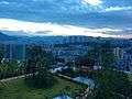 View of Wanzhou
References
- ↑ Cox, W (2018). Demographia World Urban Areas. 14th Annual Edition (PDF). St. Louis: Demographia. p. 22.
- ↑ 1995版《万县志》 概述 1
- ↑ shi, Guo wu yuan ren kou pu cha ban gong; council, Guo jia tong ji ju ren kou he jiu ye tong ji si bian = Tabulation on the 2010 population census of the people's republic of China by township / compiled by Population census office under the state; population, Department of; statistics, employment statistics national bureau of (2012). Zhongguo 2010 nian ren kou pu cha fen xiang, zhen, jie dao zi liao (Di 1 ban. ed.). Beijing Shi: Zhongguo tong ji chu ban she. ISBN 978-7-5037-6660-2.
- ↑ "现代汉语词典第七版 (Contemporary Chinese Dictionary Ed. 7.)" (in Chinese). 2016. p. 1092.
瀼 ràng 瀼渡河(Ràngdù Hé),水名,在重庆。
Missing or empty|url=(help) - ↑ http://www.sanxiau.edu.cn/重庆市万州区沙龙路二段780号 重庆市万州区天星路666号
- ↑ http://www.sxyyc.net/ 重庆市万州区百安坝天星路366号
- ↑ http://www.cqsxedu.com/ 重庆市万州区科龙路8号(火车站前)
- ↑ http://www.cqeec.com/html/8/78.html 重庆市万州区平湖路88号(金龙校区) 重庆万州区天城巨人路一号(天城校区)
- ↑ http://www.cqpec.com/ 重庆万州天城育才路1号
- ↑ http://www.cqvist.net/ 重庆市万州区百安坝安庆路583号
External links
| Wikimedia Commons has media related to Wanzhou District. |