Wanfang Community MRT station
Wanfang Community BR03 萬芳社區 | |
|---|---|
 Wanfang Community station | |
| Location |
No. 60, Wanfang Rd. Wenshan, Taipei Taiwan |
| Operated by | |
| Line(s) |
|
| Connections | Bus stop |
| Construction | |
| Structure type | Elevated |
| History | |
| Opened | 28 March 1996 |
| Traffic | |
| Passengers |
4,201 daily (2016)[1] (Ranked 109th of 109) |
| Wanfang Community MRT station | |||||||||||||
| Traditional Chinese | 萬芳社區站 | ||||||||||||
|---|---|---|---|---|---|---|---|---|---|---|---|---|---|
| Simplified Chinese | 万芳社区站 | ||||||||||||
| |||||||||||||
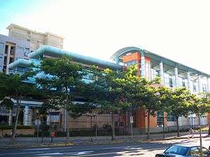
Wanfang Community station is a station on Brown Line of the Taipei Metro, located in Wenshan District, Taipei, Taiwan.[2]
Station overview
The two-level, elevated station has two side platforms, and has a single exit. It is located on the south side of Wanfang Rd., close to its intersection with Wanhe Rd.
Station layout
| 2F | |
| Side platform, doors will open on the right | |
| Platform 1 | ← |
| Platform 2 | → |
| Side platform, doors will open on the right | |
| 1F | |
| Concourse | Exit/Entrance, lobby, information desk, automatic ticket dispensing machines, one-way faregates, restrooms |
Exits
- Single Exit: Wanfang Rd.

Around the station
- Wanfang Community
- Wanfang Elementary School
- Yuanye Sports Park
| Preceding station | Following station | |||
|---|---|---|---|---|
| Wanfang Hospital towards Nangang Exhib Center |
Wenhu line | Muzha towards Taipei Zoo | ||
References
| Wikimedia Commons has media related to Wanfang Community Station. |
- ↑ "Passenger Volume at Taipei Rapid Transit Stations" (PDF). Taipei City Department of Transportation. 2017-03-13. Retrieved 2017-03-13.
- ↑ "Route Map: Wanfang Community". Taipei Rapid Transit Corporation. Retrieved 2010-06-10.
| Stations |
| ||||
|---|---|---|---|---|---|
| Rolling stock |
| ||||
Coordinates: 24°59′55″N 121°34′05″E / 24.998639°N 121.56801°E
This article is issued from
Wikipedia.
The text is licensed under Creative Commons - Attribution - Sharealike.
Additional terms may apply for the media files.