Nangang Software Park MRT station
Nangang Software Park BR23 南港軟體園區 | |
|---|---|
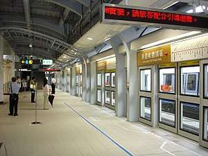 Nangang Software Park station platform | |
| Location |
No. 183, Jingmao 2nd Rd. Nangang, Taipei Taiwan |
| Operated by | |
| Line(s) |
|
| Connections | Bus stop |
| Construction | |
| Structure type | Elevated |
| History | |
| Opened | 4 July 2009 |
| Traffic | |
| Passengers |
7,702 daily (2016)[1] (Ranked 102nd of 109) |
| Nangang Software Park MRT station | |||||||||||||
| Traditional Chinese | 南港軟體園區站 | ||||||||||||
|---|---|---|---|---|---|---|---|---|---|---|---|---|---|
| Simplified Chinese | 南港软体园区站 | ||||||||||||
| |||||||||||||
The Taipei Metro Nangang Software Park station is located in the Nangang District in Taipei, Taiwan. It is a station on the Brown Line.
Station overview

This two-level, elevated station features two side platforms, two exits, and a platform elevator located on the north side of the concourse level.[2] The station is 93 meters long and 53 meters wide, while the platform is 93 meters long and 21.5 meters wide.[3]
As part of the public art project for Brown Line, the theme for this station is "Digital".[4]
History
Construction of the Nangang Software Park station began on 16 June 2003 and completed on 22 February 2009, before full opening on 4 July 2009. This station is basically named as Nangang Software Park is within the vicinity.[3]
Station layout
| 3F | Connecting Level | Overhead Bridge, Machinery |
| 2F | ||
| Side platform, doors will open on the right | ||
| Platform 1 | ← | |
| Platform 2 | → | |
| Side platform, doors will open on the right | ||
| Lobby (to Platform 2) | ||
| Lobby, information desk, automatic ticket dispensing machines one-way faregates, Restrooms | ||
| 1F | Street Level | Entrance/Exit |
| Preceding station | Following station | |||
|---|---|---|---|---|
| Taipei Nangang Exhibition Center towards Nangang Exhib Center |
Wenhu line | Donghu towards Taipei Zoo | ||
References
| Wikimedia Commons has media related to Nangang Software Park Station. |
- ↑ "Passenger Volume at Taipei Rapid Transit Stations" (PDF). Taipei City Department of Transportation. 2017-03-13. Retrieved 2017-03-13.
- ↑ "Route Map: Nangang Software Park". Department of Rapid Transit Systems, TCG. Retrieved 2010-06-14.
- 1 2 "Route Map: 南港軟體園區站". East District Project Office, Department of Rapid Transit Systems. 2009-06-11. Retrieved 2010-06-14.
- ↑ "( B10 ) Nangang Software Park". Comprehensive Planning Division, Civil Engineering and Architectural Design Division. 2009-07-04. Archived from the original on 2016-03-03. Retrieved 2009-07-12.
| Stations |
| ||||
|---|---|---|---|---|---|
| Rolling stock |
| ||||
Coordinates: 25°03′36″N 121°36′57″E / 25.059934°N 121.615874°E