Gangqian MRT station
Gangqian BR17 港墘 | |
|---|---|
 Gangqian station | |
| Location |
No. 663, Sec. 1, Neihu Rd. Neihu, Taipei Taiwan |
| Operated by | |
| Line(s) |
|
| Connections | Bus stop |
| Construction | |
| Structure type | Elevated |
| History | |
| Opened | 4 July 2009 |
| Traffic | |
| Passengers |
25,370 daily (2016)[1] (Ranked 59th of 109) |
| Gangqian MRT station | |||||||||||||
| Chinese | 港墘站 | ||||||||||||
|---|---|---|---|---|---|---|---|---|---|---|---|---|---|
| |||||||||||||
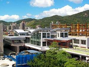
The Taipei Metro Gangqian station is located in the Neihu District in Taipei, Taiwan. It is a station on Brown Line.
Station overview
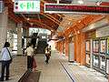
Gangqian station platform
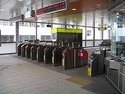
Gangqian station concourse
This three-level, elevated station features two side platforms, two exits, and platform elevators located on the north and south sides of the concourse level.[2]
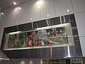
Public art for the station is situated on the wall above the escalators. The piece, titled "The Paradise of Neihu", is a large-scale mixed media artwork consisting of needlepoint created with the help of 83 artists and volunteers.[3]
History
- 22 February 2009: Gangqian station construction is completed.
- 4 July 2009: Begins service with the opening of Brown Line.
Station layout
| 4F | Connecting Level | Overhead Bridge |
| 3F | ||
| South Concourse | Information desk, automatic ticket dispensing machine one-way faregates, Escalator towards exit 2 | |
| Side platform, doors will open on the right | ||
| Platform 1 | ← | |
| Platform 2 | → | |
| Side platform, doors will open on the right | ||
| North Concourse | Information desk, automatic ticket dispensing machine, one-way faregates Restrooms, escalator towards exit 1 | |
| 1F | |
| Street Level | Entrance/Exit |
Gallery
 Gangqian station public art "The Beauty of Neihu"
- Gangqian station platform 1 (to Taipei Zoo)
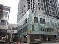 Gangqian station gateway 1
Nearby Places
- Guanshan Riverside Park
- Neihu Technology Park
- Taipei Municipal Nei-Hu Vocational High School
- Neihu Community College
- Taipei Flower Market
- Lishan Elementary School
- Lishan Junior High School
- Lishan High School
- Neihu Sports Center
| Preceding station | Following station | |||
|---|---|---|---|---|
| Wende towards Nangang Exhib Center |
Wenhu line | Xihu towards Taipei Zoo | ||
References
| Wikimedia Commons has media related to Gangqian Station. |
- ↑ "Passenger Volume at Taipei Rapid Transit Stations" (PDF). Taipei City Department of Transportation. 2017-03-13. Retrieved 2017-03-13.
- ↑ "Route Map: Gangqian". Department of Rapid Transit Systems, TCG. 2009-06-30. Archived from the original on 2011-09-02. Retrieved 2010-12-07.
- ↑ "Public Art on the Neihu Line". Department of Rapid Transit Systems. Retrieved 2010-12-07.
| Stations |
| ||||
|---|---|---|---|---|---|
| Rolling stock |
| ||||
Coordinates: 25°04′48″N 121°34′30″E / 25.080088°N 121.575124°E
This article is issued from
Wikipedia.
The text is licensed under Creative Commons - Attribution - Sharealike.
Additional terms may apply for the media files.