Wallhalben
| Wallhalben | ||
|---|---|---|
| ||
 Wallhalben Location of Wallhalben within Südwestpfalz district 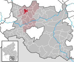 | ||
| Coordinates: 49°19′1″N 7°31′38″E / 49.31694°N 7.52722°ECoordinates: 49°19′1″N 7°31′38″E / 49.31694°N 7.52722°E | ||
| Country | Germany | |
| State | Rhineland-Palatinate | |
| District | Südwestpfalz | |
| Municipal assoc. | Thaleischweiler-Wallhalben | |
| Government | ||
| • Mayor | Berthold Martin | |
| Area | ||
| • Total | 4.87 km2 (1.88 sq mi) | |
| Elevation | 312 m (1,024 ft) | |
| Population (2017-12-31)[1] | ||
| • Total | 864 | |
| • Density | 180/km2 (460/sq mi) | |
| Time zone | CET/CEST (UTC+1/+2) | |
| Postal codes | 66917 | |
| Dialling codes | 06375 | |
| Vehicle registration | PS | |
| Website | www.wallhalben.de | |

Wallhalben is a municipality in the Südwestpfalz district, in Rhineland-Palatinate, Germany. It is situated approximately 15 km northwest of Pirmasens, and 15 km northeast of Zweibrücken.
Until 1 July 2014, when it became part of the Verbandsgemeinde ("collective municipality") Thaleischweiler-Wallhalben, Wallhalben was the seat of the Verbandsgemeinde Wallhalben.
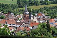
View to Wallhalben
References
- ↑ Statistisches Landesamt Rheinland-Pfalz "Bevölkerungsstand 2017 - Gemeindeebene" Check
|url=value (help). Statistisches Landesamt Rheinland-Pfalz (in German). 2018.
This article is issued from
Wikipedia.
The text is licensed under Creative Commons - Attribution - Sharealike.
Additional terms may apply for the media files.