Fischbach bei Dahn
| Fischbach bei Dahn | ||
|---|---|---|
 | ||
| ||
 Fischbach bei Dahn Location of Fischbach bei Dahn within Südwestpfalz district 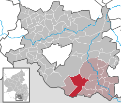 | ||
| Coordinates: 49°05′15″N 7°42′38″E / 49.08750°N 7.71056°ECoordinates: 49°05′15″N 7°42′38″E / 49.08750°N 7.71056°E | ||
| Country | Germany | |
| State | Rhineland-Palatinate | |
| District | Südwestpfalz | |
| Municipal assoc. | Dahner Felsenland | |
| Government | ||
| • Mayor | Josef Hammer | |
| Area | ||
| • Total | 32.88 km2 (12.70 sq mi) | |
| Elevation | 195 m (640 ft) | |
| Population (2017-12-31)[1] | ||
| • Total | 1,522 | |
| • Density | 46/km2 (120/sq mi) | |
| Time zone | CET/CEST (UTC+1/+2) | |
| Postal codes | 66996 | |
| Dialling codes | 06393 | |
| Vehicle registration | PS | |
| Website | www.fischbach-bei-dahn.de | |

Fischbach bei Dahn is a municipality in Südwestpfalz district, in Rhineland-Palatinate, western Germany.
The hollow in which Fischbach lies is surrounded by hills rising to around 400 metres above sea level. The highest hills in the general area are: to the northeast the Große Eyberg (514 m) and, to the south, beyond the French border, the Maimont (512 m). The summits of both hills are about four kilometres from the village.
When the US military began to downsize in the 1990s, the small US Army posts associated with Husterhoeh Kaserne (Pirmasens) were returned to Germany, including ones located at Maßweiler, Munchweiler, Fischbach, and Clausen.
References
- ↑ Statistisches Landesamt Rheinland-Pfalz "Bevölkerungsstand 2017 - Gemeindeebene" Check
|url=value (help). Statistisches Landesamt Rheinland-Pfalz (in German). 2018.
This article is issued from
Wikipedia.
The text is licensed under Creative Commons - Attribution - Sharealike.
Additional terms may apply for the media files.