Vlorë County
| Vlorë County Qarku Vlorë | ||
|---|---|---|
| County | ||
| ||
 | ||
| Coordinates: 41°N 20°E / 41°N 20°E | ||
| Country |
| |
| Municipality(s) | 7 | |
| Villages | 197 | |
| Seat | Vlorë | |
| Government | ||
| • Council chairman | Sadrit Danaj | |
| Area | ||
| • Total | 2,706 km2 (1,045 sq mi) | |
| Area rank | 5th | |
| Population (2016) | ||
| • Total | 183,105[1] | |
| • Rank | 7th | |
| Time zone | UTC+1 (CET) | |
| • Summer (DST) | UTC+2 (CEST) | |
| Website | Official Website | |

Vlorë County (Albanian: Qarku i Vlorës) is one of the 12 counties of the Republic of Albania, with the capital in Vlorë. The county spans 2,706 square kilometres (1,045 sq mi) and had a total population of 183,105 people as of 2016. The county borders on the counties of Fier, Gjirokastër, and the Adriatic and Ionian Sea.
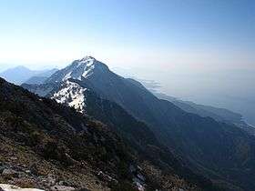
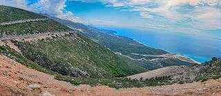
Vlorë is geographically a very mountainous county. The county stretches along the Adriatic Sea and especially the Ionian Sea, forming the Albanian Riviera. The county has a coastline of 244 kilometres (152 mi).[2] The coasts on the west can be very steep and rocky with green panoramic vistas and high mountains in the hinterland, including the Ceraunian Mountains. The highest natural point is Maja e Çikës, at 2,044 metres (6,706 ft). Although the northwest of the county is comprised mostly by the peninsula of Karaburun with a rough relief, steep cliffs, bays and rocky beaches.
With more than 180.000 inhabitants in 2016, the county is the seventh most populous Albanian county, and the third most populous county of the Southern Region. Albanians predominate in the county, including the capital city. In addition, Greeks, Aromanians, Macedonians and Montenegrins also are present in the ethnic composition of the local population of the county.
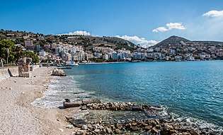
The port city Vlorë is the capital of Vlorë County. It is where the Albanian Declaration of Independence was proclaimed on November 28, 1912. Sarandë is one of the most important tourist attractions of the Albanian Riviera. It is situated on an open sea gulf of the Ionian Sea in the central Mediterranean, about 14 km (8.7 mi) east of the north end of the Greek island of Corfu. The Butrint National Park, Llogara National Park and Karaburun Sazan National Marine Park are located in Vlorë County. The ancient city of Butrint is an archeological site in Vlorë County, some 14 kilometres south of Sarandë. It is located on a hill overlooking the Vivari Channel and is part of the Butrint National Park.
History
During the antiquity the city of Vlorë, the homonymous county capital, was known as Aulón (Greek: Αυλών with the meaning channel or glen and possibly a translation of another indigenous name.[3][4] The city was founded in antiquity as a Greek colony inside the territory of Illyria. The Latin name is Aulona, a Latinization of the Ancient Greek name. The medieval and modern Greek name was Αυλώνας /av'lonas/, accusative Αυλώνα /av'lona/, and is the source of the Italian name Valona and of the obsolete English Avlona.[5][6] During the Ottoman era, the Turkish Avlonya was also common.[7]
In antiquity the region was inhabited by the Greek tribe of the Chaonians. The Ancient Greeks developed the town of Sarandë which they referred to as Onchesmos (or Anchiasmos)[8][9][10] Onchesmos flourished as the port of the Chaonian capital of Phoenice[11][12] (modern-day Finiq). Further north another Chaonian settlement was founded, Himarë,[13] while the Corinthians found the colony of Aulon at the bay of Vlorë. Additional ancient settlements in the region included Thronium, Amantia, Oricum.
In the Middle Ages, the region was part of the Byzantine Empire, while during the Slavic invasion there is evidence the Byzantine rule was maintained in the area.[14]
In 1204 the region became part of the Despotate of Epirus but returned to the Byzantine Empire. In 1335 Albanian tribes descended south and were in possession of the area between Berat and the bay of Vlore,[15] while in 1345 after the Serbian invasion an independent principality was formed in Vlorë.
In the middle of the 14th century the aristocratic Delvina family ruled Delvinë and in 1354, Mehmet Ali Pasha Delvina was testified as the owner of the castle and the city.
Geography
Vlorë is one of 12 counties of Albania, located south and southwest of the Southern Region. It is divided into seven municipalities. These are Delvinë, Finiq, Himarë, Konispol, Sarandë, Selenicë and Vlorë.[16] The municipalities are further subdivided into 200 towns and villages in total. The county lies between latitudes 41° N, and longitudes 20° E. The county area is 2,706 km2 (1,045 sq mi) and the fifth unit of the Albanian county in area and the third in the Southern Region, behind Korçë County and Gjirokastër County. It is limited to the counties of Fier in the north, Gjirokastër in the east, the country of Greece in the south and the Adriatic Sea in the northwest and the Ionian Sea in the west.
Phytogeographically, the county falls within the Illyrian deciduous forests terrestrial ecoregion of the Palearctic Mediterranean forests, woodlands, and scrub. Inside the county, there are three national parks, namely Llogara National Park, Karaburun-Sazan Marine Park, and Butrint National Park.

Vlorë County is located in the south of Albania and forms the Albanian Riviera. The southeastern part of the county borders Greece. The county has a total area of 2,706 km2 (1,044.8 sq mi).[17] The three main cities are Vlorë, Sarandë and Delvinë.
In Vlorë there are five islands located. The Ksamil Islands are four small islands located in Vlorë. The combined areas of the four Ksamili islands is only 7.1 hectares (17.5 acres) and form part of the larger Butrint National Park.[18]
Sazan Island is strategically located between the Strait of Otranto and the entrance to the Bay of Vlorë and has an area of 5.7 km2 (2.2 sq mi) with no civil population. In addition to being the largest island in Albania, it is a military facility and sometimes in clear weather it may be seen by eye from the coast of Salento, Italy. More than half of the island's surrounding marine area forms part of the Karaburun-Sazan National Marine Park.[19] Stillo Island is rocky and sparsely vegetated. It has an area of half an hectare, with an approximate length of 80 meters and a width of 100 meters. It is located in the Ionian Sea, 200 meters off the coast of Cape Stillo. Tongo Island is a rocky island, and its waters are rich in aquatic life. The island is situated about 300 metres (984 feet) off the Greek coast. It has an area of 2.5 hectares (6.2 acres). Zvernec Islands are two islands located in Narta Lagoon. The Big Zvërnec Island is nearly all covered with tall pine trees and is connected to the mainland by a 270m long wooden bridge. It is 430m in length and 300m in width. It has an area of around 8.8 hectares. The Small Zvërnec Island is less important and much smaller than the Big Zvërnec Island. It has a smaller vegetation, it is 230 m in length and 100 m in width and has an area of little more than 1 hectares.
Demographics
The population of Vlorë, as defined by Institute of Statistics of Albania, was estimated in 2011 to be 175,640.[17] The census results, have been widely disputed due to irregularities in the procedure and affected by boycott.[20][21][22] The population density was 65 inhabitants per square kilometre (170/sq mi).[23] The research revealed the following numbers in the county per ethnic group: 120,637 Albanian people (68.68%), 12,079 Greek people (6.88%), 876 Aromanian people (0.50%), 282 Roma people (0.16%), 15 Egyptian people (0.01%), 7 Macedonian people (0.00%) and 1 Montenegrin (0.00%).[24]
Islam is the predominant religion in Vlorë. In 2011, 42.14% of the population of the county declared themselves as Muslims. Christianity is the second largest religion in the county, claiming 15.72% of the total population. These includes Orthodox, Evangelist and Roman Catholic believers.[24] The other religion comprising less than two per cent of the county's population is Bektashi with 1,903 adherents.
The most densely populated areas are the coastal cities of Vlorë, Sarandë and Himarë, while vast regions such as in the highlands, are very sparsely populated.
Economy
The county remains a major seaport and commercial centre, with a significant fishing and industrial sector. The city of Vlorë is the economic hub of the county. The surrounding region of the city is mainly agricultural and pastoral and a large producer of petroleum, natural gas, bitumen and salt. That has grown in importance as an agricultural center with very large-scale planting of olive and citrus fruit trees, and as a center of the food processing, oil and bitumen export industries.
According to the World Bank, Vlorë has made significant steps of starting a business in 2016. Vlorë ranks 7 among 22 cities in Southeastern Europe[25] before the capital Tirana, Belgrade, Serbia and Sarajevo, Bosnia and Herzegovina.
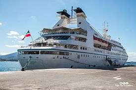
Tourism has become a major industry in recent years, with many hotels, recreational centers, and vast beaches. In Sarandë, tourism is the main driver of the economy. It is a significant tourist destination on the Ionian Sea, and by far one of the most popular destination in Albania. It's a prosperous region with varied attractions, plants and mountains, rivers and lakes, springs and virgin beaches, citrus plantations, olive groves and vineyards, pastures and woods, fish and shellfish farming, desirable hunting places.
In short, the right place for the development of tourism. Saranda's stony beaches are quite decent and there are plenty of sights in and around town, including the mesmerising ancient archaeological site of Butrint and the hypnotic Blue Eye Spring.
See also
| Wikimedia Commons has media related to Vlorë County. |
References
- ↑ "Popullsia e Shqipërisë" (PDF). instat.gov.al (in Albanian). 19 February 2016. Archived from the original (PDF) on 12 April 2016. Retrieved 12 April 2016.
- ↑ UNICEF. "ObservatOri për të drejtat e Fëmijëve Qarku vlOrë" (PDF). observator.org.al (in Albanian). p. 1.
- ↑ google book reference: Placenames of the World: Origins and Meanings of the Names for 6,600 Countries, Cities, Territories, Natural Features, and Historic Sites By Adrian Room Published by McFarland, 2005, ISBN 978-0-7864-2248-7, 433 pages.
- ↑ The New Encyclopædia Britannica. Encyclopædia Britannica. 1974. p. 479. ISBN 0-85229-290-2.
- ↑ "

- ↑ Chisholm 1911, pp. 65–66
- ↑ Gawrych, G. W. (2006). The crescent and the eagle: Ottoman rule, Islam and the Albanians, 1874-1913. I.B.Tauris. p. 23. ISBN 978-1-84511-287-5. Google Book Search. Retrieved on August 25, 2009.
- ↑ Strabo, The Geography, Book VII, Chapter 7.5: "...these mountains one comes to Onchesmus, another harbor, opposite which lie the western extremities of Corcyraea."
- ↑ Bowden, William. Epirus Vetus: The Archaeology of a Late Antique Province. London: Duckworth, 2003, ISBN 0-7156-3116-0, p. 14. "Anchiasmos (Onchesmos)"
- ↑ Hodges, Richard. Saranda - Ancient Onchesmos: A Short History and Guide. Butrint Foundation, 2007. ISBN 99943-943-6-3
- ↑ Talbert, Richard J.A. and Bagnall, Roger S. Barrington Atlas of the Greek and Roman World, 2000, p. 815. "harbor, cape or town in Epirus between Onchesmos and Bouthroton."
- ↑ Eidinow, Esther. Oracles, Curses, and Risk Among the Ancient Greeks. Oxford University Press, 2007. ISBN 0-19-927778-8 "Onchesmos was the principal port of Phoinike, the capital of Chaonia,..."
- ↑ An Inventory of Archaic and Classical Poleis: An Investigation Conducted by The Copenhagen Polis Centre for the Danish National Research Foundation by Mogens Herman Hansen, 2005, page 340.
- ↑ Winnifrith Tom. Shattered eagles, Balkan fragments. Duckworth, 1995, ISBN 978-0-7156-2635-1, p. 102
- ↑ Nicholas Geoffrey Lemprière Hammond. Migrations and invasions in Greece and adjacent areas. Noyes Press, 1976, ISBN 978-0-8155-5047-1, p. 61 "By 1335 they were in possession also of the area between Berat and the Gulf of Valona"
- ↑ "Law nr. 115/2014" (PDF). Archived from the original (PDF) on 2015-09-24. Retrieved 2015-09-24.
- 1 2 "2011 census results" (PDF). Archived from the original (PDF) on 2016-03-04. Retrieved 2017-07-17.
- ↑ National Tourism Agency. "Albanian Nature and Active Holidays" (PDF). Republic of Albania. Archived from the original (PDF) on 31 July 2009. Retrieved 4 March 2011.
- ↑ Proclamation of Karaburun-Sazan as National Marine Park, April 2010
- ↑ "Final census findings lead to concerns over accuracy". Tirana Times. Retrieved 26 May 2014.
- ↑ Likmeta, Besar. "Albania Moves Ahead With Disputed Census". Balkaninsight. Retrieved 26 May 2014.
- ↑ "Three Albanian journalists awarded with "World at 7 Billion Prize"". United Nations (Albania). Archived from the original on 28 May 2014. Retrieved 26 May 2014.
...the controversial CENSUS data
- ↑ Institute of Statistics of Albania. "Population and Housing Census" (PDF). instat.gov.al (in Albanian). p. 20. Archived from the original (PDF) on 2016-03-04. Retrieved 2017-07-17.
- 1 2 Institute of Statistics of Albania. "Population and Housing Census" (PDF). instat.gov.al (in Albanian). p. 39. Archived from the original (PDF) on 2016-03-04. Retrieved 2017-07-17.
- ↑ http://www.doingbusiness.org/Rankings/south-east-europe
| ||||||||||||||