Sazan Island
| Sazan Island | |
| Island | |
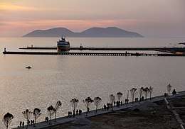 Sazan seen from the Port of Vlorë | |
| Country | Albania |
|---|---|
| State | Vlorë County |
| Municipality | Vlorë |
| Coordinates | 40°29′37″N 19°16′50″E / 40.49361°N 19.28056°ECoordinates: 40°29′37″N 19°16′50″E / 40.49361°N 19.28056°E |
| Highest point | 344 m (1,129 ft)[1] |
| Length | 4.8 km (3 mi) |
| Width | 2 km (1 mi) |
| Area | 5.7 km2 (2 sq mi) |
| Founded | National Park in 2010[2] |
| Management | Ministry of Defence and Environment |
 | |
| Location |
Albania |
|---|---|
| Coordinates | 40°30′14.3″N 19°15′59.8″E / 40.503972°N 19.266611°E |
| Year first constructed | 1871 (first) |
| Year first lit | 1920s (current) |
| Tower shape | cylindrical tower attached to a 2-storey keeper's house |
| Height | 11.9 metres (39 ft)[3] |
| Focal height | 157 metres (515 ft)[3] |
| Light source | solar power |
| Range | 14 nautical miles (26 km; 16 mi)[3] |
| Characteristic | Fl (4) W 15s.[3] |
| Admiralty number | E3723 |
| NGA number | 14328 |
| ARLHS number | ALB-004[4] |
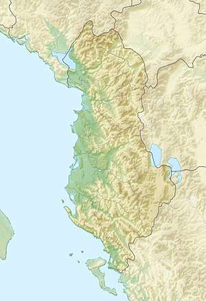
Sazan (definite Albanian form: Sazani; Italian: Saseno; Latin: Saso; Ancient Greek: Σάσων) is an island inside the Mediterranean Sea in southern Albania. It is the largest island in Albania and strategically located between the Strait of Otranto and the entrance to the Bay of Vlorë, forming the border between the Adriatic and Ionian Sea. The island has a surface area of 5.7 km2 (2.2 sq mi) with a length of 4.8 km (3.0 mi), width of 2 km (1.2 mi) and a coastline of about 15 km (9.3 mi).[5]
In addition to being the largest island in Albania, it is a military zone and sometimes in clear weather it may be seen by eye from the coast of Salento, Italy in the west. The island was open to the public in July 2015.[6] 2,721.87 hectares (6,725.9 acres) of the territory of the island's surrounding marine area became part of the Karaburun-Sazan Marine Park in 2010.[7]
History

The island was known as Sason (Ancient Greek: Σάσων) in antiquity and was already mentioned by Polybius in a military episode taking place in 215 BC. Part of the Roman and Byzantine empires, it was captured by the Anjou of Naples in 1279, and was held by Albanian lords in the 14th century, often under the protection of Venice. The Ottoman Turks captured it around 1400, but it belonged to the Venetians by 1696. From then on, it follows the fate of the Ionian Islands, which were eventually given to Britain in 1815 as an autonomous republic under British protection.[8]
In 1864 the island was ceded to Greece with the rest of the Ionian Islands as part of Diapontia Islands, but not occupied, coming under de facto Ottoman control. It was not until the First Balkan War in 1912 that Greece landed soldiers on the island and formally claimed it. After the end of the Second Balkan War in 1913, Italy and Austria-Hungary pressed Greece to evacuate the southern part of modern Albania. Finding the island too unimportant to risk war with Italy, Greece evacuated it.[9]
Italy in turn occupied it on 30 October 1914, and established a military commander on the island, which is called Saseno in Italian. This was later ratified on 26 April 1915 by the secret Treaty of London. After World War I, Albania formally ceded the island to Italy on 2 September 1920 as part of the Albano-Italian protocol. The island was part of Italy from 1920 until World War II: it was administratively part of Lagosta, inside the Italian Province of Zara. In those years the Italian authorities built a lighthouse and some naval fortifications, and populated the island with a few families of fishermen relocated from Apulia.[10] The island was united to the Italian Governatorate of Dalmatia in 1941 during World War II and ceded to Albania on 10 February 1947, under the postwar peace treaty with Italy.
During the Cold War between the Soviet Union and the United States, Albania relied heavily on the Soviet Union. During that time, the Soviets built a Whiskey-class submarines base and a Chemical/Biological weapons plant on the island and surrounding areas. After the fall of communism four submarines remained at Porto Palermo. [11] To this day, many Soviet-era gas masks can still be found scattered around the valley of the island.
The island now is uninhabited but there is a small Italo-Albanian naval base, used mainly to counter contraband between southern Italy and Albania and as a training field for the Royal Navy.[12][11] In 2010, the island's surrounding sea waters, and those of adjacent Karaburun Peninsula were proclaimed a National Marine Park by the Albanian government.
Environment
Geography and Climate

Sazan is the largest island in the country and Albania's westernmost point. It is strategically located at the entrance to the Bay of Vlorë, in the eastern Strait of Otranto separating Italy from Albania. It is also located at the informal junction line of the Adriatic and Ionian Sea inside the Mediterranean Sea, which is just to the south according to international scientific bodies.
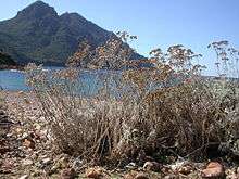
The island is composed of limestone rocks, which was formed during the Cretaceous period, while the eastern part is partially composed of terrigenic and cleistogenic deposits.[13] It has four peaks, the highest standing at 344 m (1,129 ft) above sea level followed by two peaks in the center 331 m (1,086 ft) and 307 m (1,007 ft), and the lowest with 228 m (748 ft) in the south of the island.[1] Sazan has a coastline of about 15 km (9.3 mi) characterized by sandy beaches, capes, rocky cliffs and underwater fauna. Along its western shore the cliffs descending up to 40 m (0.025 mi) underwater. Capes of the island include the Bay of Paradise (Gjiri i Parajsës), Bay of St. Nicholas (Gjiri i Shënkollit), Cape of Shenkoll, Cape of Kallam, Cape of Jug, Cape of Pellumba, and Cape of Pulbardha.[1]
The island has a climate unusual in Albania, due to its maritime location. It is not mediterranean but rather subtropical on account of its warm winters and hot summers. The climate and vegetation resemble those of the south of Crete in Greece, Tunisia and even parts of Egypt. The flora is different from that of the rest of Albania in that it is subtropical. A small tornado or watersprout was spotted along the coast coming inland in August 2002.[14]
| Climate data for Sazan (1991-2010) | |||||||||||||
|---|---|---|---|---|---|---|---|---|---|---|---|---|---|
| Month | Jan | Feb | Mar | Apr | May | Jun | Jul | Aug | Sep | Oct | Nov | Dec | Year |
| Average high °C (°F) | 16.3 (61.3) |
17.5 (63.5) |
18.6 (65.5) |
20.1 (68.2) |
22.9 (73.2) |
25.6 (78.1) |
28.4 (83.1) |
28.4 (83.1) |
25.8 (78.4) |
23.4 (74.1) |
19.6 (67.3) |
17.4 (63.3) |
22 (71.6) |
| Average low °C (°F) | 10.2 (50.4) |
10.5 (50.9) |
11.7 (53.1) |
13.3 (55.9) |
16.4 (61.5) |
21.3 (70.3) |
23.7 (74.7) |
23.4 (74.1) |
21.2 (70.2) |
16.5 (61.7) |
13.1 (55.6) |
11.1 (52) |
16 (60.9) |
| Average precipitation days | 10 | 9 | 7 | 6 | 4 | 3 | 1 | 2 | 4 | 7 | 10 | 11 | 74 |
| Source: METEOALB Weather Station | |||||||||||||
Flora and Fauna
Biogeographically, Sazan Island falls within the Illyrian deciduous forests terrestrial ecoregion of the Palearctic Mediterranean forests, woodlands, and scrub. Due to the combination of southern geographic latitude and high altitude and as well the variation of climate, geological and hydrological conditions have contributed to the formation of a unique flora inside the island.
The variety of flora and vegetation can be explained by its strategically position between the western and eastern Mediterranean Sea.[15] The island is home to 435 species (419 indigenous) of vascular plants, or 8.2% of Albania's entire vascular flora.[15] There are only an endemic (Limonium anfractum) and 3 subendemic (Centaurea pawlowski, Scutellaria rupestris and Verbascum guicciardini) plants.[15] The varied relief creates various ecological environments for plants, further diversified by the dominant rock types which form siliceous and calcareous terrain on the territory of the park. The rocky shores and limestone sea cliffs on the southern corners of Sazan are home to numerous halophile species such as lotus cytisoides and limonium anfractum.[15] The forests of Sazan are generally composed of shrubs, sclerophyll forests with holm oak, deciduous forests with hophornbeam and south european flowering ash.[15]

Due to its specific topography, climatic, hydrological and geological conditions, the island is characterized by housing a unique vegetation and biodiversity. The fauna is represented by 15 species of mammals, 39 species of birds[17], 8 species of reptiles, 1 species of amphibia and as well as 122 species of invertebrates.[16] In addition to the 15 species of mammals, 8 of them are bats; among the most common are the black rat, common pipistrelle, and soprano pipistrelle.[16] The bird species in Sazan with high conservation value include, 23 songbirds, 5 bird of preys, 3 pigeons, and 3 swifts.[16]
The amphibians are represented by 1 of which include the green toad nesting in the wet deciduous forests and the forest streams. There are 8 reptile species. The mediterranean house gecko, testudo hermanni boettgeri, balkan pond turtle, sheltopusik, blue-throated keeled lizard, balkan wall lizard, montpellier snake and balkan whip snake are present in most rocky, and wet natural habitats throughout the island.[16]
There are between 122 identified species, including 113 insects, but their actual number is estimated to be higher.[16] Among the insects are 40 are beetles, 16 butterflies, 22 heteroptera, 20 orthoptera, 5 dragonflies and 10 hymenoptera.[16]
See also
| Wikimedia Commons has media related to Sazan. |
References
- 1 2 3 Agjencia Kombëtare e Bregdetit. "MANAGEMENT PLAN FOR SAZANI ISLAND, ALBANIA" (PDF). bregdeti.gov.al. p. 11.
- ↑ "Management Plan for National Marine Park Karaburun-Sazan" (PDF). mcpa.iwlearn.org. p. 10.
National Park of the marine natural ecosystem has been proclaimed on 28 April 2010
- 1 2 3 4 List of Lights, Pub. 113: The West Coasts of Europe and Africa, the Mediterranean Sea, Black Sea and Azovskoye More (Sea of Azov) (PDF). List of Lights. United States National Geospatial-Intelligence Agency. 2015.
- ↑ "Albania". The Lighthouse Directory. University of North Carolina at Chapel Hill. Retrieved 6 April 2017.
- ↑ Agjencia Kombëtare e Bregdetit. "MANAGEMENT PLAN FOR SAZANI ISLAND, ALBANIA" (PDF). bregdeti.gov.al. p. 9.
- ↑ "FOTOLAJM/ Anija e parë turistike me 119 turistë mbërriti në Sazan". 26 July 2015. Retrieved 2 July 2016.
- ↑ "Management Plan for National Marine Park Karaburun-Sazan" (PDF). mcpa.iwlearn.org. p. 10.
The total area of National Park Karaburun-Sazan is 12,570.82 ha, with marine area near Karaburuni having 9,848.95 ha and marine area near Sazani island having 2,721.87 ha.
- ↑ Sk (24 March 2009). "The island of Sazan (Saseno, Σασων)". pyrroulas. Retrieved 2 July 2016.
- ↑ "Νήσος Σάσων: Πώς παραχωρήθηκε στην Αλβανία με Νόμο".
- ↑ Olinto Mileta. Popolazioni dell'Istria, Fiume, Zara e Dalmazia 1850-2002. ediz. A.D.E.S. Trieste, 2005
- 1 2 Ryan (March 15, 2015). "Take a Look Inside These Abandoned Submarines & Bases". History in Orbit website. p. 38. Retrieved July 6, 2018.
- ↑ Cooperation between Italy and Albania (in Italian)
- ↑ Agjencia Kombëtare e Bregdetit. "MANAGEMENT PLAN FOR SAZANI ISLAND, ALBANIA" (PDF). bregdeti.gov.al. p. 18.
- ↑ http://www.tornadoit.org/lefoto28.htm Trombe marine e tornado sull'isola di Saseno (Albania) nell'agosto 2002, Tornadoit.org
- 1 2 3 4 5 6 Agjencia Kombëtare e Bregdetit. "MANAGEMENT PLAN FOR SAZANI ISLAND, ALBANIA" (PDF). bregdeti.gov.al. p. 21-26.
- 1 2 3 4 5 6 7 Agjencia Kombëtare e Bregdetit. "MANAGEMENT PLAN FOR SAZANI ISLAND, ALBANIA" (PDF). bregdeti.gov.al. p. 27-35.
- ↑ Euronatur. "ADRIATIC FLYWAY - BIRD CONSERVATION ON THE BALKANS" (PDF). euronatur.org. pp. 107–118.