Vis (river)
| Vis | |
|---|---|
 The Vis | |
| Native name | La Vis |
| Country | France |
| Physical characteristics | |
| Main source | Cévennes |
| River mouth |
Hérault 43°56′22″N 3°41′23″E / 43.93944°N 3.68972°ECoordinates: 43°56′22″N 3°41′23″E / 43.93944°N 3.68972°E |
| Length | 57.9 km (36.0 mi) |
| Discharge |
|
| Basin features | |
| Basin size | 332 km2 (128 sq mi) |
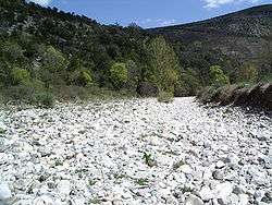
Vis sec
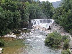
St Laurent le Minier
The Vis is a 57.9-kilometre (36.0 mi) long river in south-central France, in the Languedoc-Roussillon région, right tributary of the Hérault. Its source is in the Cévennes, near the village of Alzon. It flows between the Causse du Larzac and the Causse de Blandas into the Hérault département and the Gard département. The Vis flows into the Hérault near Ganges.
Origin of the name
The name "Vis" derives from the old Proto-Indo-European root "Vir" which means "river", and which can be found in the name of many rivers in France such as the Vire.
Towns along the river
The Vis flows through the following communes :
Hydrology and water quality
The Vis takes its source on the Saint-Guiral mount.[1]
See also
References
| Wikimedia Commons has media related to Vis River. |
- (in English) Cirque de Navacelles and the gorges of the Vis
- (in French) Banque Hydro - Station Y2035010 - La Vis à Saint-Laurent-le-Minier (Synthèse)
- (in French) Site du SANDRE
This article is issued from
Wikipedia.
The text is licensed under Creative Commons - Attribution - Sharealike.
Additional terms may apply for the media files.