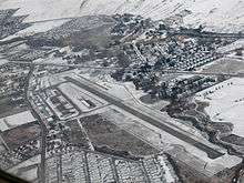
Vernon Regional Airport
| Vernon Regional Airport | |||||||||||
|---|---|---|---|---|---|---|---|---|---|---|---|
 | |||||||||||
| Summary | |||||||||||
| Airport type | Public | ||||||||||
| Owner | City of Vernon | ||||||||||
| Operator | Vernon Regional Airport Corporation | ||||||||||
| Location | Vernon, British Columbia | ||||||||||
| Time zone | PST (UTC−08:00) | ||||||||||
| • Summer (DST) | PDT (UTC−07:00) | ||||||||||
| Elevation AMSL | 1,141 ft / 348 m | ||||||||||
| Coordinates | 50°14′46″N 119°19′51″W / 50.24611°N 119.33083°WCoordinates: 50°14′46″N 119°19′51″W / 50.24611°N 119.33083°W | ||||||||||
| Website | www.vernonairport.com | ||||||||||
| Map | |||||||||||
 CYVK Location in British Columbia  CYVK CYVK (Canada) | |||||||||||
| Runways | |||||||||||
| |||||||||||
|
Source: Canada Flight Supplement[1] | |||||||||||
Vernon Regional Airport, (IATA: YVE, ICAO: CYVK), is a small, non-towered airport located 1.8 nautical miles (3.3 km; 2.1 mi) southwest of Vernon, British Columbia, Canada. It is one of the few airports in the Okanagan Valley that can offer skydiving because all commercial operators must give written consent to a skydiving company for skydiving to occur, something which is not feasible at a larger airport like Kelowna International Airport.
See also
References
- ↑ Canada Flight Supplement. Effective 0901Z 19 July 2018 to 0901Z 13 September 2018.
External links

- Official site
| By name | |
|---|---|
| By location indicator | |
| By province/territory | |
| By area | |
| National Airports System | |
| Related | |
| |
This article is issued from
Wikipedia.
The text is licensed under Creative Commons - Attribution - Sharealike.
Additional terms may apply for the media files.