Verkhoyansk
| Verkhoyansk Верхоянск (Russian) Верхоянскай (Yakut) | |
|---|---|
|
- Town[1] - Town under district jurisdiction[1] | |
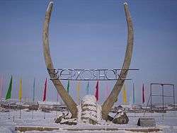 Pole of Cold in Verkhoyansk | |
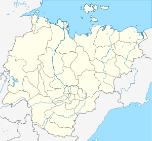
_Republic_(2008-03).svg.png) Location of the Sakha (Yakutia) Republic in Russia | |
 Verkhoyansk | |
_soviet.png) | |
|
Coat of arms | |
| Administrative status (as of June 2009) | |
| Country | Russia |
| Federal subject | Sakha Republic[1] |
| Administrative district | Verkhoyansky District[1] |
| Town | Verkhoyansk[1] |
| Administrative center of | Town of Verkhoyansk[1] |
| Municipal status (as of April 2012) | |
| Municipal district | Verkhoyansky Municipal District[2] |
| Urban settlement | Verkhoyansk Urban Settlement[2] |
| Administrative center of | Verkhoyansk Urban Settlement[2] |
| Statistics | |
| Population (2010 Census) | 1,311 inhabitants[3] |
| Time zone | VLAT (UTC+10:00)[4] |
| Founded | 1638[5][1] |
| Town status since | 1817 |
| Postal code(s)[6] | 678530 |
| Dialing code(s) | +7 41165[7] |
| Verkhoyansk on Wikimedia Commons | |
| 2010 Census | 1,311[3] |
|---|---|
| 2002 Census | 1,434[8] |
| 1989 Census | 1,883[9] |
| 1979 Census | 1,709[10] |
Verkhoyansk (Russian: Верхоянск, IPA: [vʲɪrxɐˈjansk]; Sakha: Верхоянскай, Verkhoyanskay) is a town in Verkhoyansky District of the Sakha Republic, Russia, located on the Yana River near the Arctic Circle, 92 kilometers (57 mi) from Batagay, the administrative center of the district, and 675 kilometers (419 mi) north of Yakutsk, the capital of the republic. As of the 2010 Census, its population was 1,311.[3] The town holds the Guinness world record for the greatest temperature range on Earth: 105 °C (189 °F).[11]
History
Cossacks founded an ostrog in 1638,[5] 90 kilometers (56 mi) southwest of the modern town. The ostrog's name "Verkhoyansky", roughly translating from Russian as the town on the Upper Yana, derived from its geographical location on the upper reaches of the Yana River. In 1775, it was moved to the left bank of the Yana River to facilitate tax collection. It was granted town status in 1817. Between the 1860s and 1917, the town was a place of political exile, with some of the more prominent exiles including the Polish writer Wacław Sieroszewski, as well as Bolshevik revolutionaries Ivan Babushkin and Viktor Nogin.
Administrative and municipal status
As an inhabited locality, Verkhoyansk is classified as a town under district jurisdiction.[1] Within the framework of administrative divisions, it is incorporated within Verkhoyansky District as the Town of Verkhoyansk.[1] As a municipal division, the Town of Verkhoyansk is incorporated within Verkhoyansky Municipal District as Verkhoyansk Urban Settlement.[2]
Economy and infrastructure
There is a river port, an airport, a fur-collecting depot, and the center of a reindeer-raising area. It is also home to the Pole of Cold Museum.
Geography
Climate
Verkhoyansk is notable chiefly for its exceptionally low winter temperatures and some of the greatest temperature differences on Earth between summer and winter. Average monthly temperatures range from −45.4 °C (−49.7 °F) in January to +16.5 °C (61.7 °F) in July. Mean monthly temperatures are below freezing from October through April and exceed +10 °C (50 °F) from June through August, with the intervening months of May and September constituting very short transitional seasons. Verkhoyansk has an extreme subarctic climate (Köppen Dfd) dominated much of the year by high pressure. This has the effect of cutting off the region from warming influences in winter and together with a lack of cloud cover leads to extensive heat losses during the cooler months.
Verkhoyansk is one of the places considered the northern Pole of Cold, the other being Oymyakon, located 629 km (391 miles) away by air. The lowest temperature recorded there, in February 1892, was −67.6 °C (−89.7 °F), recorded on February 5 and 7.[12][13] This was formerly the coldest officially recorded temperature in the Northern Hemisphere. However, on February 6, 1933, the temperature at Oymyakon reached −67.7 °C (−89.9 °F), just barely exceeding Verkhoyansk's record.[12][13] Only Antarctica has recorded lower temperatures than Oymyakon or Verkhoyansk: the lowest directly recorded temperature at ground level is −89.2 °C (−128.6 °F), recorded at the Vostok Station in Antarctica on July 21, 1983.[14][15], and a temperature of −93.2 °C (−135.8 °F) was recorded via satellite observations at the East Antarctic Plateau in Antarctica on August 10, 2010.[16]
In this area, temperature inversions consistently form in winter due to the extremely cold and dense air of the Siberian High pooling in deep hollows, so that temperatures increase rather than decrease with higher altitude. In Verkhoyansk it sometimes happens that the average minimum temperatures for January, February, and December are below −50 °C (−58 °F). Oymyakon and Verkhoyansk are the only two permanently populated places in the world that have recorded temperatures below −60.0 °C (−76.0 °F) every day of January.
In June, July, and August, daytime temperatures over +30 °C (86 °F) are not uncommon. The warmest month on record is July 2001, at +21.9 °C (71.4 °F).[17] The average annual temperature for Verkhoyansk is −14.5 °C (5.9 °F). On July 25, 1988, Verkhoyansk recorded a temperature of +37.3 °C (99.1 °F), yielding a temperature range of 105 °C (189 °F) based on reliable records, which is the greatest temperature range in the world. Oymyakon and Yakutsk are the only other places in the world with a temperature range higher than 100 °C (180 °F). Verkhoyansk has never recorded a temperature above freezing between November 10 and March 14.[18]
Verkhoyansk has a dry climate with little rainfall or snowfall: the average annual precipitation is 180 millimeters (7.1 in). Although no month can be described as truly wet, there are strong seasonal differences in precipitation, with the summer being much wetter than the winter. Winter precipitation is extremely light, largely because of the dominance of high pressure at this time of year.
| Climate data for Verkhoyansk | |||||||||||||
|---|---|---|---|---|---|---|---|---|---|---|---|---|---|
| Month | Jan | Feb | Mar | Apr | May | Jun | Jul | Aug | Sep | Oct | Nov | Dec | Year |
| Record high °C (°F) | −9.5 (14.9) |
−6.2 (20.8) |
5.6 (42.1) |
14.3 (57.7) |
28.1 (82.6) |
34.0 (93.2) |
37.3 (99.1) |
33.7 (92.7) |
25.1 (77.2) |
14.5 (58.1) |
1.1 (34) |
−5.3 (22.5) |
37.3 (99.1) |
| Average high °C (°F) | −42.4 (−44.3) |
−36.7 (−34.1) |
−19.3 (−2.7) |
−3 (27) |
10.0 (50) |
20.0 (68) |
23.5 (74.3) |
18.6 (65.5) |
8.5 (47.3) |
−9.1 (15.6) |
−30.7 (−23.3) |
−40.4 (−40.7) |
−8.7 (16.3) |
| Daily mean °C (°F) | −45.4 (−49.7) |
−41.8 (−43.2) |
−29.5 (−21.1) |
−12.4 (9.7) |
3.8 (38.8) |
13.4 (56.1) |
16.5 (61.7) |
11.5 (52.7) |
2.5 (36.5) |
−14.5 (5.9) |
−34.8 (−30.6) |
−43.3 (−45.9) |
−14.5 (5.9) |
| Average low °C (°F) | −48.3 (−54.9) |
−45.9 (−50.6) |
−37.9 (−36.2) |
−22.1 (−7.8) |
−2.6 (27.3) |
6.7 (44.1) |
9.7 (49.5) |
5.1 (41.2) |
−2.3 (27.9) |
−18.9 (−2) |
−38.2 (−36.8) |
−46.4 (−51.5) |
−20.1 (−4.2) |
| Record low °C (°F) | −67.8 (−90) |
−67.8 (−90) |
−60.3 (−76.5) |
−57.2 (−71) |
−34.2 (−29.6) |
−7.9 (17.8) |
−3.2 (26.2) |
−9.9 (14.2) |
−21.7 (−7.1) |
−48.7 (−55.7) |
−57.2 (−71) |
−64.5 (−84.1) |
−67.8 (−90) |
| Average precipitation mm (inches) | 6 (0.24) |
6 (0.24) |
5 (0.2) |
5 (0.2) |
14 (0.55) |
27 (1.06) |
34 (1.34) |
34 (1.34) |
19 (0.75) |
11 (0.43) |
11 (0.43) |
8 (0.31) |
180 (7.09) |
| Average snowfall cm (inches) | 20 (7.9) |
22 (8.7) |
24 (9.4) |
18 (7.1) |
1 (0.4) |
0 (0) |
0 (0) |
0 (0) |
0 (0) |
5 (2) |
12 (4.7) |
16 (6.3) |
118 (46.5) |
| Average precipitation days (≥ 1.0 mm) | 2.3 | 1.7 | 1.5 | 2.2 | 3.6 | 5.2 | 6.5 | 5.7 | 4.0 | 4.8 | 3.5 | 3.2 | 44.2 |
| Average snowy days | 17 | 15 | 12 | 8 | 4 | 0 | 0 | 0 | 4 | 17 | 18 | 16 | 111 |
| Average relative humidity (%) | 74 | 74 | 69 | 63 | 58 | 57 | 61 | 69 | 74 | 78 | 77 | 75 | 73 |
| Mean monthly sunshine hours | 6 | 84 | 219 | 280 | 309 | 354 | 327 | 219 | 132 | 84 | 26 | 1 | 2,041 |
| Source #1: Погода и Климат[19] | |||||||||||||
| Source #2: NOAA (precipitation days and sunshine hours, 1961-1990)[20] | |||||||||||||
References
Notes
- 1 2 3 4 5 6 7 8 9 Registry of the Administrative-Territorial Divisions of the Sakha Republic
- 1 2 3 4 Law #173-Z #353-III
- 1 2 3 Russian Federal State Statistics Service (2011). "Всероссийская перепись населения 2010 года. Том 1" [2010 All-Russian Population Census, vol. 1]. Всероссийская перепись населения 2010 года (2010 All-Russia Population Census) (in Russian). Federal State Statistics Service. Retrieved June 29, 2012.
- ↑ Правительство Российской Федерации. Федеральный закон №107-ФЗ от 3 июня 2011 г. «Об исчислении времени», в ред. Федерального закона №271-ФЗ от 03 июля 2016 г. «О внесении изменений в Федеральный закон "Об исчислении времени"». Вступил в силу по истечении шестидесяти дней после дня официального опубликования (6 августа 2011 г.). Опубликован: "Российская газета", №120, 6 июня 2011 г. (Government of the Russian Federation. Federal Law #107-FZ of June 31, 2011 On Calculating Time, as amended by the Federal Law #271-FZ of July 03, 2016 On Amending Federal Law "On Calculating Time". Effective as of after sixty days following the day of the official publication.).
- 1 2 Энциклопедия Города России. Moscow: Большая Российская Энциклопедия. 2003. p. 69. ISBN 5-7107-7399-9.
- ↑ Почта России. Информационно-вычислительный центр ОАСУ РПО. (Russian Post). Поиск объектов почтовой связи (Postal Objects Search) (in Russian)
- ↑ http://www.pogodaiklimat.ru/climate/24266.htm
- ↑ Russian Federal State Statistics Service (May 21, 2004). "Численность населения России, субъектов Российской Федерации в составе федеральных округов, районов, городских поселений, сельских населённых пунктов – районных центров и сельских населённых пунктов с населением 3 тысячи и более человек" [Population of Russia, Its Federal Districts, Federal Subjects, Districts, Urban Localities, Rural Localities—Administrative Centers, and Rural Localities with Population of Over 3,000] (XLS). Всероссийская перепись населения 2002 года [All-Russia Population Census of 2002] (in Russian). Retrieved August 9, 2014.
- ↑ Demoscope Weekly (1989). "Всесоюзная перепись населения 1989 г. Численность наличного населения союзных и автономных республик, автономных областей и округов, краёв, областей, районов, городских поселений и сёл-райцентров" [All Union Population Census of 1989: Present Population of Union and Autonomous Republics, Autonomous Oblasts and Okrugs, Krais, Oblasts, Districts, Urban Settlements, and Villages Serving as District Administrative Centers]. Всесоюзная перепись населения 1989 года [All-Union Population Census of 1989] (in Russian). Институт демографии Национального исследовательского университета: Высшая школа экономики [Institute of Demography at the National Research University: Higher School of Economics]. Retrieved August 9, 2014.
- ↑ "Всесоюзная перепись населения 1979 г. Национальный состав населения по регионам России. (All Union Population Census of 1979. Ethnic composition of the population by regions of Russia.)". Всесоюзная перепись населения 1979 года (All-Union Population Census of 1979) (in Russian). Demoscope Weekly (website of the Institute of Demographics of the State University—Higher School of Economics. 1979. Retrieved 2008-11-25.
- ↑ http://www.guinnessworldrecords.com/world-records/greatest-temperature-range-on-earth/
- 1 2 N. A. Stepanova. "On the Lowest Temperatures on Earth" (PDF).
- 1 2 Weather Underground - The Coldest Places on Earth https://www.wunderground.com/blog/weatherhistorian/the-coldest-places-on-earth
- ↑ "Global Weather & Climate Extremes". World Meteorological Organization. Retrieved December 23, 2015.
- ↑ "World: Lowest Temperature". World Meteorological Organization. Archived from the original on June 16, 2010. Retrieved December 23, 2015.
- ↑ "The Coldest Place in the World". NASA. Retrieved December 12, 2017.
- ↑ GHCN monthly climate data; Goddard Institute of Space Studies record for Verhojansk 1885-2010
- ↑ "Weather and Climate - Climate Monitor: The weather in Verkhoyansk" (in Russian). www.pogodaiklimat.ru. Retrieved December 25, 2013. Daily records on the right of the page; December–March records can be accessed via buttons at the bottom of the page.
- ↑ —Погода и Климат. Retrieved January 1, 2013.
- ↑ "Verhojansk Climate Normals 1961–1990". National Oceanic and Atmospheric Administration. Retrieved February 9, 2015.
Sources
- Official website of the Sakha Republic. Registry of the Administrative-Territorial Divisions of the Sakha Republic. Verkhoyansky District. (in Russian)
- Государственное Собрание (Ил Тумэн) Республики Саха (Якутия). Закон №173-З №353-III от 30 ноября 2004 г. «Об установлении границ и о наделении статусом городского и сельского поселений муниципальных образований Республики Саха (Якутия)», в ред. Закона №1058-З №1007-IV от 25 апреля 2012 г. «О внесении изменений в Закон Республики Саха (Якутия) "Об установлении границ и о наделении статусом городского и сельского поселений муниципальных образований Республики Саха (Якутия)"». Вступил в силу со дня официального опубликования. Опубликован: "Якутия", №245, 31 декабря 2004 г. (State Assembly (Il Tumen) of the Sakha (Yakutia) Republic. Law #173-Z No. 353-III of November 30, 2004 On Establishing the Borders and on Granting the Urban and Rural Settlement Status to the Municipal Formations of the Sakha (Yakutia) Republic, as amended by the Law #1058-Z No. 1007-IV of April 25, 2012 On Amending the Law of the Sakha (Yakutia) Republic "On Establishing the Borders and on Granting the Urban and Rural Settlement Status to the Municipal Formations of the Sakha (Yakutia) Republic". Effective as of the day of the official publication.).