Varsi
| Varsi | ||
|---|---|---|
| Comune | ||
| Comune di Varsi | ||
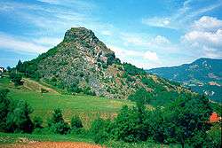 Groppo della Rocca, near Varsi. | ||
| ||
 Varsi Location of Varsi in Italy | ||
| Coordinates: 44°40′N 9°51′E / 44.667°N 9.850°E | ||
| Country | Italy | |
| Region | Emilia-Romagna | |
| Province | Parma (PR) | |
| Frazioni | Baghetti, Bianchi, Contile, Corticella, Ferrè, Franchini, Lagadello, Leonardi, Lubbia Sopra, Lubbia Sotto, Manini, Michelotti, Minassi, Peracchi, Peretti, Perotti, Pessola, Pietracavata, Rocca, Scaffardi, Scortichiere, Sgui, Tognoni, Tosca, Villora, Volpi | |
| Government | ||
| • Mayor | Luigi Aramini | |
| Area | ||
| • Total | 79.6 km2 (30.7 sq mi) | |
| Elevation | 426 m (1,398 ft) | |
| Population (31 May 2007)[1] | ||
| • Total | 1,352 | |
| • Density | 17/km2 (44/sq mi) | |
| Demonym(s) | Varsigiani | |
| Time zone | UTC+1 (CET) | |
| • Summer (DST) | UTC+2 (CEST) | |
| Postal code | 43049 | |
| Dialing code | 0525 | |
| Website | Official website | |
Varsi (Parmigiano: Värz) is a comune (municipality) in the Province of Parma in the Italian region Emilia-Romagna, located about 120 kilometres (75 mi) west of Bologna and about 40 kilometres (25 mi) southwest of Parma.
References


| Authority control |
|---|
This article is issued from
Wikipedia.
The text is licensed under Creative Commons - Attribution - Sharealike.
Additional terms may apply for the media files.