Terenzo
| Terenzo | |
|---|---|
| Comune | |
| Comune di Terenzo | |
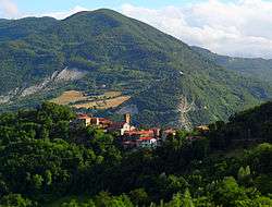 The village of Castello di Casola in Terenzo | |
 Terenzo Location of Terenzo in Italy | |
| Coordinates: 44°37′N 10°5′E / 44.617°N 10.083°ECoordinates: 44°37′N 10°5′E / 44.617°N 10.083°E | |
| Country | Italy |
| Region | Emilia-Romagna |
| Province | Province of Parma (PR) |
| Frazioni | Bardone, Boschi di Bardone, Case Castellani, Cassio, Castello, Castello di Casola, Cazzola, Corniana, Goiano, Lesignano Palmia, Lughero, Palmia, Puilio, Selva Grossa, Stazione Bocchetto, Villa, Villa di Casola, Viola |
| Area | |
| • Total | 72.4 km2 (28.0 sq mi) |
| Population (Dec. 2004) | |
| • Total | 1,250 |
| • Density | 17/km2 (45/sq mi) |
| Time zone | UTC+1 (CET) |
| • Summer (DST) | UTC+2 (CEST) |
| Postal code | 43040 |
| Dialing code | 0525 |
| Website | Official website |
Terenzo (Parmigiano: Tréns) is a comune (municipality) in the Province of Parma in the Italian region Emilia-Romagna, located about 100 kilometres (62 mi) west of Bologna and about 30 kilometres (19 mi) southwest of Parma. As of 31 December 2004, it had a population of 1,250 and an area of 72.4 square kilometres (28.0 sq mi).[1]
The municipality of Terenzo contains the frazioni (subdivisions, mainly villages and hamlets) Bardone, Boschi di Bardone, Case Castellani, Cassio, Castello, Castello di Casola, Cazzola, Corniana, Goiano, Lesignano Palmia, Lughero, Palmia, Puilio, Selva Grossa, Stazione Bocchetto, Villa, Villa di Casola, and Viola.
At the foot of Monte Zirone, is the slender former church or Pieve di San Michele di Corniana, dedicate to St Michael Archangel. Also nearby is the Pieve di Bardone, completed prior to 13th-century.
Terenzo borders the following municipalities: Berceto, Calestano, Fornovo di Taro, Sala Baganza, Solignano.
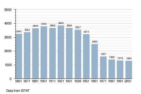
Demographic evolution
References
External links

| Authority control |
|---|