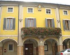
Soragna
| Soragna | ||
|---|---|---|
| Comune | ||
| Comune di Soragna | ||
 | ||
| ||
 Soragna Location of Soragna in Italy | ||
| Coordinates: 44°56′N 10°7′E / 44.933°N 10.117°E | ||
| Country | Italy | |
| Region | Emilia-Romagna | |
| Province | Parma (PR) | |
| Frazioni | Carzeto, Castellina, Diolo | |
| Government | ||
| • Mayor | Salvatore Iaconi Farina | |
| Area | ||
| • Total | 45 km2 (17 sq mi) | |
| Elevation | 49 m (161 ft) | |
| Population (31 December 2016[1]) | ||
| • Total | 4,834 | |
| • Density | 110/km2 (280/sq mi) | |
| Time zone | UTC+1 (CET) | |
| • Summer (DST) | UTC+2 (CEST) | |
| Postal code | 43019 | |
| Dialing code | 0524 | |
Soragna (Parmigiano: Suràgna) is a town and comune in the province of Parma of northern Italy with a population of about 4,800.
The town is known from 712, when it was mentioned in a document by the Lombard king Liutprand. From 1198 it was a possession of the Lupi family and was an imperial fief (a marquisate from 1347 and a principate from 1709), with the right to mint coins.
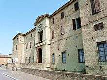
It is home to a medieval rocca (fortress), turned into a palace, called the Rocca Meli Lupi. It has 16th century frescoes by Cesare Baglione, possibly Niccolò dell'Abbate, and others. The surrounding park was turned into an English garden around 1820.
Among its churches are:
Twin towns
References
Sources
- Mordacci, Alessandra, ed. (2009). La Rocca di Soragna. Parma: Gazzetta di Parma Editore.
External links
- Website about the Rocca di Soragna (in Italian)
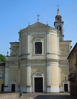 San Giacomo (Saint James) church.

| Authority control |
|---|
This article is issued from
Wikipedia.
The text is licensed under Creative Commons - Attribution - Sharealike.
Additional terms may apply for the media files.