Vanj Range
| Vanj Range Ванчский хребет Қаторкӯҳи Ванҷ | |
|---|---|
 View of the Vanj Range | |
| Highest point | |
| Peak | High Yazgulem Peak |
| Elevation | 5,588 m (18,333 ft) |
| Coordinates | 38°33′00″N 72°01′00″E / 38.5500°N 72.0167°ECoordinates: 38°33′00″N 72°01′00″E / 38.5500°N 72.0167°E |
| Dimensions | |
| Length | 85 km (53 mi) NE/SW |
| Width | 15 km (9.3 mi) NW/SE |
| Geography | |
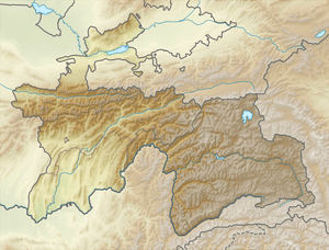 Location in Tajikistan | |
| Country | Tajikistan |
| Parent range | Pamir Mountains |
| Geology | |
| Age of rock | Paleozoic |
| Type of rock | Granite, conglomerate and sandstone |
The Vanj Range (Russian: Ванчский хребет; Tajik: Қаторкӯҳи Ванҷ) is a mountain range of Vanj district, Gorno-Badakhshan, Tajikistan.
Geography
It lies to the south of the Academy of Sciences Range, between the Darvaz Range to the north and the Yazgulem Range to the south. Running parallel to them, it separates the valleys of the Vanj River and the Yazgulyam River.[1] The total glaciated area of the range is 164 km².[2]
Peaks
Its highest summit is glacier-covered High Yazgulem Peak (5,588 m). Other peaks are Vanchek Peak (5,428 m), Hauck Peak (5,092 m), Kuh-i Rau (4,964 m), Sokolov Peak (4,808 m) and Ku-i Zoh (4,664 m).[1]
See also
References
- 1 2 Ванчский хребет в Большой энциклопедии Кирилла и Мефодия
- ↑ Ванчский хребет - article from the Great Soviet Encyclopedia
| Districts | 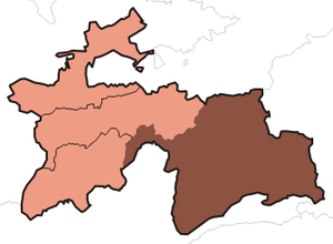 | |
|---|---|---|
| Main cities and towns | ||
| Geography | ||
This article is issued from
Wikipedia.
The text is licensed under Creative Commons - Attribution - Sharealike.
Additional terms may apply for the media files.