Vanand, Armavir
Coordinates: 40°08′N 43°49′E / 40.133°N 43.817°E
| Vanand Վանանդ | |
|---|---|
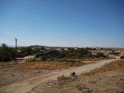 The Village of Vanand. | |
 Vanand Վանանդ | |
| Coordinates: 40°08′N 43°49′E / 40.133°N 43.817°E | |
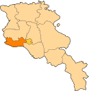
| Country | Armenia |
| Marz (Province) | Armavir |
| Founded | 1984 |
| Area | |
| • Total | 31.75 km2 (12.26 sq mi) |
| Elevation | 980 m (3,220 ft) |
| Population (2001) | |
| • Total | 845 |
| • Density | 27/km2 (69/sq mi) |
| Time zone | UTC+4 ( ) |
| • Summer (DST) | UTC+5 ( ) |
Vanand (Armenian: Վանանդ) is a village located in the southwestern portion of the Armavir Province in Armenia, 5 kilometers from the Armenian border with Turkey.[1] The village was founded in 1984 from a sovkhoz (collective farm), and was an area that was once closed to foreigners. There is a single school (179 students), house of culture, community center, kindergarten, and no cultural heritage monuments.[2]
See also
References
- ↑ Kiesling, Brady; Kojian, Raffi (2005). Rediscovering Armenia: Guide (2nd ed.). Yerevan: Matit Graphic Design Studio. p. 71. ISBN 99941-0-121-8.
- ↑ "Vanand (Armavir)". CAA: Union of Communities of Armenia. Retrieved May 29, 2015.
- Report of the results of the 2001 Armenian Census, National Statistical Service of the Republic of Armenia
- Kiesling, Brady (2005), Rediscovering Armenia: Guide, Yerevan, Armenia: Matit Graphic Design Studio
- Brady Kiesling, Rediscovering Armenia, p. 39; original archived at Archive.org, and current version online on Armeniapedia.org.
External links
| Wikimedia Commons has media related to Vanand. |
This article is issued from
Wikipedia.
The text is licensed under Creative Commons - Attribution - Sharealike.
Additional terms may apply for the media files.