Tsaghkalanj
Coordinates: 40°12′00″N 44°13′39″E / 40.20000°N 44.22750°E
| Tsaghkalanj Ծաղկալանջ | |
|---|---|
 Tsaghkalanj Ծաղկալանջ | |
| Coordinates: 40°12′00″N 44°13′39″E / 40.20000°N 44.22750°E | |
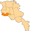
| Country | Armenia |
| Marz (Province) | Armavir |
| Population (2008) | |
| • Total | 1,321 |
| Time zone | UTC+4 ( ) |
| • Summer (DST) | UTC+5 ( ) |
Tsaghkalanj (Armenian: Ծաղկալանջ, also Romanized as Tsakhkalandzh; until 1978, Agdzhakala and Aghjaghala) is a village in the Armavir Province of Armenia. The village's church, dedicated to Saint George (Surb Gevorg), dates to the 1870s. It rests on an earlier circular foundation. Nearby, is the whitewashed Amenaprkich Church of an unknown date. There is also a Neolithic-Chalcolithic tell in the village and Bronze Age burial mounds, while the ruins of Amenaprkich, a medieval settlement are nearby.[1]
Gallery
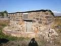 S. Gevorg chapel (1870's, restored 2003)
See also
References
- Tsaghkalanj at GEOnet Names Server
- World Gazeteer: Armenia – World-Gazetteer.com
- Report of the results of the 2001 Armenian Census, National Statistical Service of the Republic of Armenia
- Kiesling, Brady (2005), Rediscovering Armenia: Guide, Yerevan, Armenia: Matit Graphic Design Studio
- Brady Kiesling, Rediscovering Armenia, p. 36; original archived at Archive.org, and current version online on Armeniapedia.org.
External links
| Wikimedia Commons has media related to Cultural heritage monuments in Tsaghkalanj, Armavir. |
This article is issued from
Wikipedia.
The text is licensed under Creative Commons - Attribution - Sharealike.
Additional terms may apply for the media files.