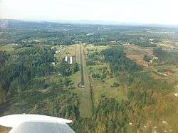
Valley View Airport
| Valley View Airport | |||||||||||
|---|---|---|---|---|---|---|---|---|---|---|---|
 | |||||||||||
| Summary | |||||||||||
| Airport type | Public | ||||||||||
| Operator | Private Owner | ||||||||||
| Location | Estacada, Oregon | ||||||||||
| Elevation AMSL | 735 ft / 224 m | ||||||||||
| Coordinates | 45°18′29.4350″N 122°19′7.31″W / 45.308176389°N 122.3186972°WCoordinates: 45°18′29.4350″N 122°19′7.31″W / 45.308176389°N 122.3186972°W | ||||||||||
| Runways | |||||||||||
| |||||||||||
Valley View Airport (FAA LID: 5S9), is a privately owned, public use airport located 1 mile (1.6 km) northeast of Estacada in Clackamas County, Oregon, United States.
External links
- Resources for this airport:
- FAA airport information for 5S9
- AirNav airport information for 5S9
- FlightAware airport information and live flight tracker
- SkyVector aeronautical chart for 5S9
This article is issued from
Wikipedia.
The text is licensed under Creative Commons - Attribution - Sharealike.
Additional terms may apply for the media files.