Nehalem Bay State Airport
| Nehalem Bay State Airport | |||||||||||
|---|---|---|---|---|---|---|---|---|---|---|---|
| Summary | |||||||||||
| Airport type | Public | ||||||||||
| Operator | Oregon Department of Aviation | ||||||||||
| Location | Manzanita, Oregon | ||||||||||
| Elevation AMSL | 22 ft / 6.7 m | ||||||||||
| Coordinates | 45°41′53.3820″N 123°55′47.48″W / 45.698161667°N 123.9298556°WCoordinates: 45°41′53.3820″N 123°55′47.48″W / 45.698161667°N 123.9298556°W | ||||||||||
| Runways | |||||||||||
| |||||||||||
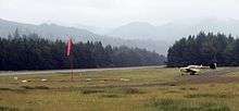
The Nehalem Bay State Airport on a still morning.
Nehalem Bay State Airport (FAA LID: 3S7), is a public airport located two miles (3.2 km) southeast of Manzanita in Tillamook County, Oregon, USA. The airport is located within the boundaries of Nehalem Bay State Park. The airport also offers several campsites for fly-in camping, just a few steps away from the tiedown area. About a ten-minute walk to the north is the town of Manzanita, offering dining and lodging.
See also
External links
- Resources for this airport:
- FAA airport information for 3S7
- AirNav airport information for 3S7
- FlightAware airport information and live flight tracker
- SkyVector aeronautical chart for 3S7
This article is issued from
Wikipedia.
The text is licensed under Creative Commons - Attribution - Sharealike.
Additional terms may apply for the media files.