Boardman Airport
| Boardman Airport | |||||||||||
|---|---|---|---|---|---|---|---|---|---|---|---|
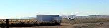 Airplane and hangar at Boardman airport | |||||||||||
| Summary | |||||||||||
| Airport type | Public | ||||||||||
| Operator | Port of Morrow | ||||||||||
| Location | Morrow County, near Boardman, Oregon | ||||||||||
| Elevation AMSL | 396 ft / 120.7 m | ||||||||||
| Coordinates | 45°48′53.3700″N 119°49′13.80″W / 45.814825000°N 119.8205000°WCoordinates: 45°48′53.3700″N 119°49′13.80″W / 45.814825000°N 119.8205000°W | ||||||||||
| Website | Port of Morrow | ||||||||||
| Runways | |||||||||||
| |||||||||||
Boardman Airport (FAA LID: M50), is a public airport 4 miles (6.4 km) southwest of the city of Boardman in Morrow County, in the U.S. state of Oregon.
History
The airport was built by the United States Army Air Forces about 1942, and was known as Boardman Flight Strip. It was an emergency landing airfield for military aircraft on training flights at the Boardman Bombing Range. It was closed after World War II, and was turned over for local government use by the War Assets Administration (WAA).
See also
Further reading
- Shaw, Frederick J. (2004), Locating Air Force Base Sites History's Legacy, Air Force History and Museums Program, United States Air Force, Washington DC, 2004.
References
![]()
External links
- Resources for this airport:
- FAA airport information for M50
- AirNav airport information for M50
- FlightAware airport information and live flight tracker
- SkyVector aeronautical chart for M50
This article is issued from
Wikipedia.
The text is licensed under Creative Commons - Attribution - Sharealike.
Additional terms may apply for the media files.