Credera Rubbiano
| Credera Rubbiano Credéra Rübià (Lombard) | |
|---|---|
| Comune | |
| Comune di Credera Rubbiano | |
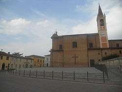 A square in Credera Rubbiano. | |
 Credera Rubbiano Location of Credera Rubbiano in Italy | |
| Coordinates: 45°18′N 9°40′E / 45.300°N 9.667°ECoordinates: 45°18′N 9°40′E / 45.300°N 9.667°E | |
| Country | Italy |
| Region | Lombardy |
| Province | Cremona (CR) |
| Government | |
| • Mayor | Matteo Guerini Rocco |
| Area | |
| • Total | 14.4 km2 (5.6 sq mi) |
| Elevation | 69 m (226 ft) |
| Population (30 June 2017)[1] | |
| • Total | 1,605 |
| • Density | 110/km2 (290/sq mi) |
| Demonym(s) | Crederesi |
| Time zone | UTC+1 (CET) |
| • Summer (DST) | UTC+2 (CEST) |
| Postal code | 26010 |
| Dialing code | 0373 |
| Website | Official website |
Credera Rubbiano (Cremasco: Credéra Rübià) is a comune (municipality) in the Province of Cremona in the Italian region Lombardy, located about 45 kilometres (28 mi) southeast of Milan and about 35 kilometres (22 mi) northwest of Cremona. It was created in 1928 through the merger of the former communes of Credera and Rubbiano.
Credera Rubbiano borders the following municipalities: Capergnanica, Casaletto Ceredano, Cavenago d'Adda, Moscazzano, Ripalta Cremasca, Turano Lodigiano.
References

This article is issued from
Wikipedia.
The text is licensed under Creative Commons - Attribution - Sharealike.
Additional terms may apply for the media files.