Ostiano
| Ostiano Üstià (Lombard) | |
|---|---|
| Comune | |
| Comune di Ostiano | |
 Ostiano Location of Ostiano in Italy | |
| Coordinates: 45°13′N 10°15′E / 45.217°N 10.250°ECoordinates: 45°13′N 10°15′E / 45.217°N 10.250°E | |
| Country | Italy |
| Region | Lombardy |
| Province | Province of Cremona (CR) |
| Area | |
| • Total | 19.4 km2 (7.5 sq mi) |
| Population (Dec. 2004) | |
| • Total | 3,054 |
| • Density | 160/km2 (410/sq mi) |
| Time zone | UTC+1 (CET) |
| • Summer (DST) | UTC+2 (CEST) |
| Postal code | 26032 |
| Dialing code | 0372 |
| Website | Official website |
Ostiano (Brescian: Üstià) is a comune (municipality) in the Province of Cremona in the Italian region Lombardy, located about 90 kilometres (56 mi) southeast of Milan and about 20 kilometres (12 mi) northeast of Cremona. As of 31 December 2004, it had a population of 3,054 and an area of 19.4 square kilometres (7.5 sq mi).[1]
Ostiano borders the following municipalities: Gabbioneta-Binanuova, Gambara, Pessina Cremonese, Pralboino, Seniga, Volongo.
Among the churches in the territory are:
- Oratory of the Disciplini
- Pieve di San Gaudenzio former abbey church
- San Michele Arcangelo parish church
- Chiesa di Torricella Romanesque oratory
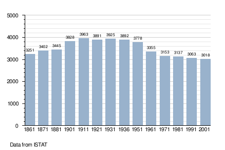
Demographic evolution
References
External links

This article is issued from
Wikipedia.
The text is licensed under Creative Commons - Attribution - Sharealike.
Additional terms may apply for the media files.