Upper Deerfield Township, New Jersey
| Upper Deerfield Township, New Jersey | |
|---|---|
| Township | |
| Township of Upper Deerfield | |
 | |
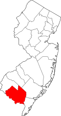
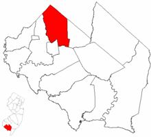 Upper Deerfield Township highlighted in Cumberland County. Inset map: Cumberland County highlighted in the State of New Jersey. | |
 Census Bureau map of Upper Deerfield Township, New Jersey | |
| Coordinates: 39°29′42″N 75°13′01″W / 39.494923°N 75.216943°WCoordinates: 39°29′42″N 75°13′01″W / 39.494923°N 75.216943°W[1][2] | |
| Country |
|
| State |
|
| County | Cumberland |
| Incorporated | April 3, 1922 |
| Government[3] | |
| • Type | Township |
| • Body | Township Committee |
| • Mayor | James P. Crilley (R, term ends December 31, 2017)[4][5] |
| • Administrator / Municipal clerk | Roy J. Spoltore[6] |
| Area[1] | |
| • Total | 31.275 sq mi (81.002 km2) |
| • Land | 31.098 sq mi (80.543 km2) |
| • Water | 0.177 sq mi (0.458 km2) 0.57% |
| Area rank |
83rd of 566 in state 8th of 14 in county[1] |
| Elevation[7] | 92 ft (28 m) |
| Population (2010 Census)[8][9][10] | |
| • Total | 7,660 |
| • Estimate (2016)[11] | 7,489 |
| • Rank |
299th of 566 in state 5th of 14 in county[12] |
| • Density | 246.3/sq mi (95.1/km2) |
| • Density rank |
492nd of 566 in state 5th of 14 in county[12] |
| Time zone | UTC-5 (Eastern (EST)) |
| • Summer (DST) | UTC-4 (Eastern (EDT)) |
| ZIP code | 08302 - Seabrook[13] |
| Area code(s) | 856[14] |
| FIPS code | 3401174870[1][15][16] |
| GNIS feature ID | 0882055[1][17] |
| Website |
www |
Upper Deerfield Township is a township in Cumberland County, New Jersey, United States. It is part of the Vineland-Millville-Bridgeton Primary Metropolitan Statistical Area for statistical purposes. As of the 2010 United States Census, the township's population was 7,660,[8][9][10] reflecting an increase of 104 (+1.4%) from the 7,556 counted in the 2000 Census, which had in turn increased by 629 (+9.1%) from the 6,927 counted in the 1990 Census.[18]
Upper Deerfield Township was incorporated as a township by an act of the New Jersey Legislature on February 23, 1922, from portions of Deerfield Township, based on the results of a referendum held on April 3, 1922.[19][20] The township was named for Deerfield Township, which in turn was named for Deerfield, Massachusetts.[21]
It is a dry town, where alcohol cannot be sold, as affirmed by a referendum passed in 1972.[22][23] Upper Deerfield does not have its own police force and is protected by the New Jersey State Police.[24]
Geography
According to the United States Census Bureau, the township had a total area of 31.275 square miles (81.002 km2), including 31.098 square miles (80.543 km2) of land and 0.177 square miles (0.458 km2) of water (0.57%).[1][2]
Seabrook Farms (2010 population of 1,484[25]) is an unincorporated community and census-designated place (CDP) located within Upper Deerfield Township.[26]
Other unincorporated communities, localities and place names located partially or completely within the township include Beals Mills, Carlls Corners, Deerfield, Delaby, Finley, Friendship, Grammel Mills, Husted Station, Pleasant Grove, Seabrook, Seeley, Silver Lake, Sunset, Sunset Lake, Watsons Corner and Woodruff.[27]
The township borders Hopewell Township, Bridgeton, Fairfield Township, Deerfield Township, and Salem County.
Demographics
| Historical population | |||
|---|---|---|---|
| Census | Pop. | %± | |
| 1930 | 2,051 | — | |
| 1940 | 2,020 | −1.5% | |
| 1950 | 5,203 | 157.6% | |
| 1960 | 6,040 | 16.1% | |
| 1970 | 6,648 | 10.1% | |
| 1980 | 6,810 | 2.4% | |
| 1990 | 6,927 | 1.7% | |
| 2000 | 7,556 | 9.1% | |
| 2010 | 7,660 | 1.4% | |
| Est. 2016 | 7,489 | [11][28] | −2.2% |
| Population sources:1930-2000[29] 1930[30] 1930-1990[31] 2000[32][33] 2010[8] | |||
Census 2010
As of the 2010 United States Census, there were 7,660 people, 2,866 households, and 2,104 families residing in the township. The population density was 246.3 per square mile (95.1/km2). There were 3,025 housing units at an average density of 97.3 per square mile (37.6/km2). The racial makeup of the township was 74.67% (5,720) White, 12.96% (993) Black or African American, 1.27% (97) Native American, 2.65% (203) Asian, 0.00% (0) Pacific Islander, 5.38% (412) from other races, and 3.07% (235) from two or more races. Hispanic or Latino of any race were 9.43% (722) of the population.[8]
There were 2,866 households out of which 28.4% had children under the age of 18 living with them, 53.9% were married couples living together, 15.3% had a female householder with no husband present, and 26.6% were non-families. 22.1% of all households were made up of individuals, and 10.9% had someone living alone who was 65 years of age or older. The average household size was 2.65 and the average family size was 3.08.[8]
In the township, the population was spread out with 23.5% under the age of 18, 8.2% from 18 to 24, 23.2% from 25 to 44, 28.8% from 45 to 64, and 16.4% who were 65 years of age or older. The median age was 41.2 years. For every 100 females there were 93.0 males. For every 100 females ages 18 and older there were 89.6 males.[8]
The Census Bureau's 2006-2010 American Community Survey showed that (in 2010 inflation-adjusted dollars) median household income was $53,646 (with a margin of error of +/- $6,771) and the median family income was $61,974 (+/- $9,964). Males had a median income of $45,532 (+/- $5,633) versus $36,741 (+/- $10,855) for females. The per capita income for the borough was $26,033 (+/- $2,581). About 8.9% of families and 12.4% of the population were below the poverty line, including 18.0% of those under age 18 and 4.8% of those age 65 or over.[34]
Census 2000
As of the 2000 United States Census[15] there were 7,556 people, 2,757 households, and 2,125 families residing in the township. The population density was 242.9 people per square mile (93.8/km²). There were 2,881 housing units at an average density of 92.6 per square mile (35.8/km²). The racial makeup of the township was 75.77% White, 16.41% African American, 0.81% Native American, 3.06% Asian, 0.01% Pacific Islander, 1.83% from other races, and 2.12% from two or more races. Hispanic or Latino of any race were 4.54% of the population.[32][33]
There were 2,757 households out of which 35.8% had children under the age of 18 living with them, 57.1% were married couples living together, 15.6% had a female householder with no husband present, and 22.9% were non-families. 20.0% of all households were made up of individuals and 10.4% had someone living alone who was 65 years of age or older. The average household size was 2.73 and the average family size was 3.12.[32][33]
In the township the population was spread out with 27.8% under the age of 18, 7.4% from 18 to 24, 25.5% from 25 to 44, 25.1% from 45 to 64, and 14.2% who were 65 years of age or older. The median age was 38 years. For every 100 females, there were 94.1 males. For every 100 females age 18 and over, there were 87.5 males.[32][33]
The median income for a household in the township was $47,861, and the median income for a family was $51,472. Males had a median income of $37,064 versus $23,719 for females. The per capita income for the township was $18,884. About 10.1% of families and 13.7% of the population were below the poverty line, including 23.2% of those under age 18 and 10.8% of those age 65 or over.[32][33]
Parks and recreation
Sunset Lake is a reservoir located primarily in Hopewell Township and Upper Deerfield Township that was created by damming a stream that feeds to the area from Seeley Lake.
Government
Local government
Upper Deerfield Township is governed under the Township form of government. The five-member Township Committee is elected at-large directly by the voters in partisan elections to serve three-year terms of office on a staggered basis, with either one or seats coming up for election each year as part of the November general election.[3] At an annual reorganization meeting, the Township Committee selects one of its members to serve as Mayor and another as Deputy Mayor.
As of 2016, members of the Upper Deerfield Township Committee are Mayor James P. Crilley (R, term on committee ends December 31, 2017; term as mayor ends 2016), Deputy Mayor John T. "Terry" O'Neill Sr. (D, term on committee ends 2018; term as deputy mayor ends 2016), John L. Daddario (R, 2016), Bruce T. Peterson (D, 2016) and Scott R. Smith (R, 2018).[4][35][36][37][38][39]
Federal, state and county representation
Upper Deerfield Township is located in the 2nd Congressional District[40] and is part of New Jersey's 3rd state legislative district.[9][41][42]
New Jersey's Second Congressional District is represented by Frank LoBiondo (R, Ventnor City).[43] New Jersey is represented in the United States Senate by Democrats Cory Booker (Newark, term ends 2021)[44] and Bob Menendez (Paramus, 2019).[45][46]
For the 2018–2019 session (Senate, General Assembly), the 3rd Legislative District of the New Jersey Legislature is represented in the State Senate by Stephen M. Sweeney (D, West Deptford Township) and in the General Assembly by John J. Burzichelli (D, Paulsboro) and Adam Taliaferro (D, Woolwich Township).[47][48] The Governor of New Jersey is Phil Murphy (D, Middletown Township).[49] The Lieutenant Governor of New Jersey is Sheila Oliver (D, East Orange).[50]
Cumberland County is governed by a seven-member Board of Chosen Freeholders, who are elected at-large in partisan elections to serve staggered three-year terms in office, with either two or three seats coming up for election each year in a three-year cycle. At an annual reorganization meeting held each January, the freeholders select one member to serve as Freeholder Director and another as Deputy Director.[51] As of 2018, Cumberland County's Freeholders are Freeholder Director Joseph Derella Jr. (D, Millville, term as freeholder and as freeholder director ends December 31, 2018),[52] Deputy Freeholder Director Darlene R. Barber (D, Upper Deerfield Township, term as freeholder ends 2019, term as deputy freeholder director ends 2018),[53] George Castellini (D, Vineland, 2020),[54] Carol Musso (D, Deerfield Township, 2020),[55] James F. Quinn (D, Millville, 2018),[56] Joseph V. Sparacio (R, Deerfield Township, 2019)[57] and Jack Surrency (D, Bridgeton 2020).[58][59][60][61] The county's constitutional officers are Clerk Celeste Riley (D, Bridgeton, 2019),[62][63] Sheriff Robert A. Austino (D, Vineland, 2020)[64][65] and Surrogate Douglas M. Rainear (D, Upper Deerfield Township, 2018).[66][67][60]
Politics
As of March 23, 2011, there were a total of 5,179 registered voters in Upper Deerfield Township, of which 1,296 (25.0%) were registered as Democrats, 1,189 (23.0%) were registered as Republicans and 2,693 (52.0%) were registered as Unaffiliated. There was one voter registered to another party.[68]
In the 2012 presidential election, Republican Mitt Romney received 52.7% of the vote (1,839 cast), ahead of Democrat Barack Obama with 46.2% (1,614 votes), and other candidates with 1.1% (37 votes), among the 3,513 ballots cast by the township's 5,361 registered voters (23 ballots were spoiled), for a turnout of 65.5%.[69][70] In the 2008 presidential election, Republican John McCain received 51.2% of the vote (1,864 cast), ahead of Democrat Barack Obama, who received 46.5% (1,694 votes), with 3,640 ballots cast among the township's 5,150 registered voters, for a turnout of 70.7%.[71] In the 2004 presidential election, Republican George W. Bush received 54.5% of the vote (1,842 ballots cast), outpolling Democrat John Kerry, who received around 43.2% (1,460 votes), with 3,377 ballots cast among the township's 4,734 registered voters, for a turnout percentage of 71.3.[72]
In the 2013 gubernatorial election, Republican Chris Christie received 66.0% of the vote (1,397 cast), ahead of Democrat Barbara Buono with 32.5% (687 votes), and other candidates with 1.6% (33 votes), among the 2,147 ballots cast by the township's 5,158 registered voters (30 ballots were spoiled), for a turnout of 41.6%.[73][74] In the 2009 gubernatorial election, Republican Chris Christie received 50.3% of the vote (1,213 ballots cast), ahead of both Democrat Jon Corzine with 39.8% (959 votes) and Independent Chris Daggett with 7.0% (169 votes), with 2,411 ballots cast among the township's 5,064 registered voters, yielding a 47.6% turnout.[75]
Education
The Upper Deerfield Township Schools serve public school students in pre-kindergarten through eighth grade. As of the 2014-15 school year, the district and its three schools had an enrollment of 1,316 students and 71.9 classroom teachers (on an FTE basis), for a student–teacher ratio of 18.3:1.[76] Schools in the district (with 2014-15 enrollment data from the National Center for Education Statistics[77]) are Charles F. Seabrook School[78] (grades PreK-3; 472 students) Elizabeth E. Moore School[79] (4-5,; 184) and Woodruff School[80] (6-8; 257 students).[81][82][83]
Public school students in ninth through twelfth grades attend Cumberland Regional High School, which also serves students from Deerfield Township, Fairfield Township, Greenwich Township, Hopewell Township, Shiloh Borough and Stow Creek Township.[84][85][86] As of the 2014-15 school year, the high school had an enrollment of 1,354 students and 87.9 classroom teachers (on an FTE basis), for a student–teacher ratio of 15.4:1.[87]
Transportation
Roads and highways
As of May 2010, the township had a total of 103.73 miles (166.94 km) of roadways, of which 29.56 miles (47.57 km) were maintained by the municipality, 64.38 miles (103.61 km) by Cumberland County and 9.79 miles (15.76 km) by the New Jersey Department of Transportation.[88]
Route 77 enters from Bridgeton on the township's southern border and heads north through the center of the township for 7.6 miles (12.2 km) to Upper Pittsgrove Township at the northern tip of Upper Deerfield Township.[89] Route 56 (Landis Avenue) branches off from Route 77 near the township's border with Bridgeton and heads northeast for 4.8 miles (7.7 km) towards Pittsgrove Township.[90]
County Route 540 (Deerfield Road) traverses the northern quarter of the township for 4.6 miles (7.4 km) from Hopewell Township in the west towards Pittsgrove Township on the east.[91] County Route 553 (South Woodruff Road / East Finley Road / Centerton Road) runs along the eastern side of the township for 6.6 miles (10.6 km) from Fairfield Township in the south towards Pittsgrove Township in the northeast corner.[92] County Route 552 (Irving Avenue) follows the southern border of the township for 2.3 miles (3.7 km) from Bridgeton in the west towards Fairfield Township in the southeast corner of the township.[93]
Public transportation
NJ Transit offers service on the 410 route between Bridgeton and Philadelphia, and the 553 route between Upper Deerfield Township and Atlantic City.[94]
Notable people
People who were born in, residents of, or otherwise closely associated with Upper Deerfield Township include:
- Charles F. Seabrook (1881–1964), business man and owner of Seabrook Farms, a family-owned frozen vegetable packing plant that at one point was the largest irrigated truck farm in the world, who was the namesake of Seabrook community and the Charles F. Seabrook School.[95]
Points of interest
- Deerfield Pike Tollgate House - added to the National Register of Historic Places in 1975, it was demolished in 2001.
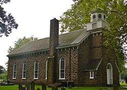
- Deerfield Presbyterian Church
References
- 1 2 3 4 5 6 County Subdivisions: New Jersey - 2010 Census Gazetteer Files, United States Census Bureau. Accessed October 24, 2012.
- 1 2 US Gazetteer files: 2010, 2000, and 1990, United States Census Bureau. Accessed September 4, 2014.
- 1 2 2012 New Jersey Legislative District Data Book, Rutgers University Edward J. Bloustein School of Planning and Public Policy, March 2013, p. 19.
- 1 2 Township Committee, Upper Deerfield Township. Accessed July 1, 2016.
- ↑ 2017 New Jersey Mayors Directory, New Jersey Department of Community Affairs. Accessed May 30, 2017.
- ↑ Clerk/Administrator, Upper Freehold Township. Accessed July 1, 2016.
- ↑ U.S. Geological Survey Geographic Names Information System: Township of Upper Deerfield, Geographic Names Information System. Accessed March 14, 2013.
- 1 2 3 4 5 6 DP-1 - Profile of General Population and Housing Characteristics: 2010 for Upper Deerfield township, Cumberland County, New Jersey, United States Census Bureau. Accessed October 24, 2012.
- 1 2 3 Municipalities Grouped by 2011-2020 Legislative Districts, New Jersey Department of State, p. 3. Accessed January 6, 2013.
- 1 2 Profile of General Demographic Characteristics: 2010 for Upper Deerfield township, New Jersey Department of Labor and Workforce Development. Accessed October 24, 2012.
- 1 2 PEPANNRES - Annual Estimates of the Resident Population: April 1, 2010 to July 1, 2016 - 2016 Population Estimates for New Jersey municipalities, United States Census Bureau. Accessed June 16, 2017.
- 1 2 GCT-PH1 Population, Housing Units, Area, and Density: 2010 - State -- County Subdivision from the 2010 Census Summary File 1 for New Jersey, United States Census Bureau. Accessed October 24, 2012.
- ↑ Look Up a ZIP Code for Upper Deerfield, NJ, United States Postal Service. Accessed October 24, 2012.
- ↑ Area Code Lookup - NPA NXX for Upper Deerfield, NJ, Area-Codes.com. Accessed November 7, 2013.
- 1 2 American FactFinder, United States Census Bureau. Accessed September 4, 2014.
- ↑ A Cure for the Common Codes: New Jersey, Missouri Census Data Center. Accessed October 24, 2012.
- ↑ US Board on Geographic Names, United States Geological Survey. Accessed September 4, 2014.
- ↑ Table 7. Population for the Counties and Municipalities in New Jersey: 1990, 2000 and 2010 Archived 2013-05-20 at the Wayback Machine., New Jersey Department of Labor and Workforce Development, February 2011. Accessed October 24, 2012.
- ↑ Snyder, John P. The Story of New Jersey's Civil Boundaries: 1606-1968, Bureau of Geology and Topography; Trenton, New Jersey; 1969. p. 122. Accessed October 25, 2012.
- ↑ Staff. Acts of the One Hundred and Forty-Sixth Legislature of the State of New Jersey, pp. 47-49. New Jersey Secretary of State, 1922. Accessed October 16, 2015. "An Act to incorporate the township of Upper Deerfield, in the county of Cumberland."
- ↑ Hutchinson, Viola L. The Origin of New Jersey Place Names, New Jersey Public Library Commission, May 1945. Accessed October 16, 2015.
- ↑ New Jersey Division of Alcoholic Beverage Control. New Jersey ABC list of dry towns (May 1, 2013)
- ↑ Giordano, Rita. "More towns catching liquor-license buzz; Moorestown considers ending its dry spell", The Philadelphia Inquirer, June 24, 2007. Accessed February 16, 2014.
- ↑ Gallo Jr., Bill. "Shooting of 76-year-old man by State Police a 'tragic mistake,' family friend says", NJ Advance Media for NJ.com, July 30, 2016. Accessed June 26, 2017. "Police, in most cases, go to the scene of a 911 hang-up call just to be sure there is nothing wrong. Upper Deerfield does not have its own police force and relies on State Police to patrol the township."
- ↑ DP-1 - Profile of General Population and Housing Characteristics: 2010 Demographic Profile Data for Seabrook Farms CDP, New Jersey, United States Census Bureau. Accessed October 24, 2012.
- ↑ New Jersey: 2010 - Population and Housing Unit Counts - 2010 Census of Population and Housing (CPH-2-32), United States Census Bureau, August 2012. Accessed October 24, 2012.
- ↑ Locality Search, State of New Jersey. Accessed May 14, 2017.
- ↑ Census Estimates for New Jersey April 1, 2010 to July 1, 2016, United States Census Bureau. Accessed June 16, 2017.
- ↑ Barnett, Bob. Population Data for Cumberland County Municipalities, 1810 - 2010, WestJersey.org. January 6, 2011. Accessed October 24, 2012.
- ↑ Fifteenth Census of the United States : 1930 - Population Volume I, United States Census Bureau, p. 715. Accessed October 24, 2012.
- ↑ New Jersey Resident Population by Municipality: 1930 - 1990 Archived 2015-05-10 at the Wayback Machine., Workforce New Jersey Public Information Network. Accessed June 28, 2015.
- 1 2 3 4 5 Census 2000 Profiles of Demographic / Social / Economic / Housing Characteristics for Upper Deerfield township, Cumberland County, New Jersey, United States Census Bureau. Accessed October 24, 2012.
- 1 2 3 4 5 DP-1: Profile of General Demographic Characteristics: 2000 - Census 2000 Summary File 1 (SF 1) 100-Percent Data for Upper Deerfield township, Cumberland County, New Jersey, United States Census Bureau. Accessed October 24, 2012.
- ↑ DP03: Selected Economic Characteristics from the 2006-2010 American Community Survey 5-Year Estimates for Upper Deerfield township, Cumberland County, New Jersey, United States Census Bureau. Accessed October 24, 2012.
- ↑ 2016 Municipal Data Sheet, Upper Deerfield Township. Accessed July 1, 2016.
- ↑ 2016 Directory of Cumberland County, New Jersey, Cumberland County, New Jersey. Accessed June 30, 2016.
- ↑ Cumberland County GENERAL - November 3rd, 2015 Official Results, Cumberland County, New Jersey, updated November 3, 2015. Accessed June 30, 2016.
- ↑ Cumberland County General - November 4, 2014 Official Results, Cumberland County, New Jersey, updated March 17, 2015. Accessed June 30, 2016.
- ↑ Cumberland County General - November 5, 2013 Unofficial Results, Cumberland County, New Jersey, updated November 6, 2013. Accessed June 30, 2016.
- ↑ Plan Components Report, New Jersey Redistricting Commission, December 23, 2011. Accessed January 6, 2013.
- ↑ 2017 New Jersey Citizen's Guide to Government Archived 2017-04-07 at the Wayback Machine., p. 65, New Jersey League of Women Voters. Accessed May 30, 2017.
- ↑ Districts by Number for 2011-2020, New Jersey Legislature. Accessed January 6, 2013.
- ↑ Directory of Representatives: New Jersey, United States House of Representatives. Accessed January 5, 2012.
- ↑ About Cory Booker, United States Senate. Accessed January 26, 2015. "He now owns a home and lives in Newark's Central Ward community."
- ↑ Biography of Bob Menendez, United States Senate, January 26, 2015. "He currently lives in Paramus and has two children, Alicia and Robert."
- ↑ Senators of the 114th Congress from New Jersey. United States Senate. Accessed January 26, 2015. "Booker, Cory A. - (D - NJ) Class II; Menendez, Robert - (D - NJ) Class I"
- ↑ Legislative Roster 2018-2019 Session, New Jersey Legislature. Accessed January 21, 2018.
- ↑ District 3 Legislators, New Jersey Legislature. Accessed January 22, 2018.
- ↑ Governor Phil Murphy, State of New Jersey. Accessed January 16, 2018.
- ↑ Lieutenant Governor Oliver, State of New Jersey. Accessed January 16, 2018. "Assemblywoman Oliver has resided in the City of East Orange for over 40 years."
- ↑ About Cumberland County Government, Cumberland County, New Jersey. Accessed June 7, 2018. "By law, Cumberland County is allowed 7 freeholders, who serve staggered, overlapping three year terms. Two are elected in two successive years, three in the third year, elected from the county at-large. A Director of the Board is selected by his colleagues for a one year term."
- ↑ Joseph Derella, Cumberland County, New Jersey. Accessed June 7, 2018.
- ↑ Darlene Barber, Cumberland County, New Jersey. Accessed June 7, 2018.
- ↑ George Castellini, Cumberland County, New Jersey. Accessed June 7, 2018.
- ↑ Carol Musso, Cumberland County, New Jersey. Accessed June 7, 2018.
- ↑ James F. Quinn, Cumberland County, New Jersey. Accessed June 7, 2018.
- ↑ Joseph V. Sparacio, Cumberland County, New Jersey. Accessed June 7, 2018.
- ↑ Jack Surrency, Cumberland County, New Jersey. Accessed June 7, 2018.
- ↑ The Cumberland County Board of Chosen Freeholders, Cumberland County, New Jersey. Accessed June 7, 2018.
- 1 2 2018 Directory of Cumberland County, New Jersey, Cumberland County, New Jersey. Accessed June 7, 2018.
- ↑ 2018 County Data Sheet, Cumberland County, New Jersey. Accessed June 7, 2018.
- ↑ County Clerk: Celeste M. Riley, Cumberland County Clerk's Office. Accessed June 7, 2018.
- ↑ Members List: Clerks, Constitutional Officers Association of New Jersey. Accessed June 7, 2018.
- ↑ Sheriff's Office, Cumberland County, New Jersey. Accessed June 7, 2018.
- ↑ Members List: Sheriffs, Constitutional Officers Association of New Jersey. Accessed June 7, 2018.
- ↑ Cumberland County Surrogate Office, Cumberland County, New Jersey. Accessed June 7, 2018.
- ↑ Members List: Surrogates, Constitutional Officers Association of New Jersey. Accessed June 7, 2018.
- ↑ Voter Registration Summary - Cumberland, New Jersey Department of State Division of Elections, March 23, 2011. Accessed October 24, 2012.
- ↑ "Presidential General Election Results - November 6, 2012 - Cumberland County" (PDF). New Jersey Department of Elections. March 15, 2013. Retrieved December 24, 2014.
- ↑ "Number of Registered Voters and Ballots Cast - November 6, 2012 - General Election Results - Cumberland County" (PDF). New Jersey Department of Elections. March 15, 2013. Retrieved December 24, 2014.
- ↑ 2008 Presidential General Election Results: Cumberland County, New Jersey Department of State Division of Elections, December 23, 2008. Accessed October 24, 2012.
- ↑ 2004 Presidential Election: Cumberland County, New Jersey Department of State Division of Elections, December 13, 2004. Accessed October 24, 2012.
- ↑ "Governor - Cumberland County" (PDF). New Jersey Department of Elections. January 29, 2014. Retrieved December 24, 2014.
- ↑ "Number of Registered Voters and Ballots Cast - November 5, 2013 - General Election Results - Cumberland County" (PDF). New Jersey Department of Elections. January 29, 2014. Retrieved December 24, 2014.
- ↑ 2009 Governor: Cumberland County, New Jersey Department of State Division of Elections, December 31, 2009. Accessed October 24, 2012.
- ↑ District information for Upper Deerfield Township School District, National Center for Education Statistics. Accessed December 7, 2016.
- ↑ School Data for the Upper Deerfield Township Schools, National Center for Education Statistics. Accessed December 7, 2016.
- ↑ Charles F. Seabrook School, Upper Deerfield Township Schools. Accessed December 29, 2016.
- ↑ Elizabeth E. Moore School, Upper Deerfield Township Schools. Accessed December 29, 2016.
- ↑ Woodruff School, Upper Deerfield Township Schools. Accessed December 29, 2016.
- ↑ Schools, Upper Deerfield Township Schools. Accessed December 29, 2016.
- ↑ Administration, Upper Deerfield Township Schools. Accessed December 29, 2016.
- ↑ New Jersey School Directory for the Upper Deerfield Township Schools, New Jersey Department of Education. Accessed December 29, 2016.
- ↑ Cumberland Regional School District 2015 Report Card Narrative, New Jersey Department of Education. Accessed June 5, 2016. "The Cumberland Regional School District, located in Western Cumberland County, provides students with a comprehensive learning environment in a nurturing and personalized setting. The district serves students in grades 9-12 who reside in the municipalities of Deerfield, Fairfield, Greenwich & Stow Creek, Hopewell & Shiloh, and Upper Deerfield."
- ↑ Shott, Meghan. "Cumberland Regional High School", South Jersey magazine. Accessed June 5, 2016. "Cumberland Regional High School, located in the northwest part of Cumberland County, serves students from Deerfield Township, Fairfield Township, Greenwich Township, Hopewell Township, Shiloh Borough, Stow Creek Township and Upper Deerfield Township."
- ↑ Constituent Districts, Cumberland Regional High School. Accessed June 5, 2016.
- ↑ School data for Cumberland Regional High School, National Center for Education Statistics. Accessed December 12, 2016.
- ↑ Cumberland County Mileage by Municipality and Jurisdiction, New Jersey Department of Transportation, May 2010. Accessed November 7, 2013.
- ↑ Route 77 Straight Line Diagram, New Jersey Department of Transportation, January 2009. Accessed November 7, 2013.
- ↑ Route 56 Straight Line Diagram, New Jersey Department of Transportation, February 2009. Accessed November 7, 2013.
- ↑ County Route 540 Straight Line Diagram, New Jersey Department of Transportation, October 2006. Accessed November 7, 2013.
- ↑ County Route 553 Straight Line Diagram, New Jersey Department of Transportation, September 2007. Accessed November 7, 2013.
- ↑ County Route 552 Straight Line Diagram, New Jersey Department of Transportation, October 2006. Accessed November 7, 2013.
- ↑ South Jersey Transit Guide, Cross County Connection, as of April 1, 2010. Accessed December 15, 2014.
- ↑ "Our People of the Century - Charles F. Seabrook: A Head for Business, A Heart for People", Cumberland County, New Jersey. Accessed December 22, 2014. "Charles F. Seabrook, often called 'The Henry Ford of Agriculture,' headed Seabrook Frams, which became one of the largest producers of frozen vegetables in the world.... He's credited for bringing refugees from many 20th century upheavals, to work at Seabrook Farms in Upper Deerfield."
External links
- Upper Deerfield Township website
- Cumberland County web page for Fairfield Township
- Upper Deerfield Township Schools
- Upper Deerfield Township Schools's 2015–16 School Report Card from the New Jersey Department of Education
- School Data for the Upper Deerfield Township Schools, National Center for Education Statistics
- Cumberland Regional High School