Uppalapadu
| Uppalapadu | |
|---|---|
| Village | |
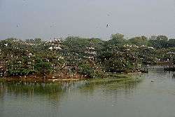 Heronry at Uppalpadu | |
 Uppalapadu Location in Andhra Pradesh, India  Uppalapadu Uppalapadu (India) | |
| Coordinates: 16°11′N 80°18′E / 16.18°N 80.30°ECoordinates: 16°11′N 80°18′E / 16.18°N 80.30°E | |
| Country | India |
| State | Andhra Pradesh |
| District | Guntur |
| Area[1] | |
| • Total | 16.60 km2 (6.41 sq mi) |
| Elevation | 19 m (62 ft) |
| Population (2011)[1] | |
| • Total | 6,175 |
| • Density | 370/km2 (960/sq mi) |
| Languages | |
| • Official | Telugu |
| Time zone | UTC+5:30 (IST) |
| Lok Sabha constituency | Guntur |
Uppalapadu is a village in Guntur district of the Indian state of Andhra Pradesh. It is located in Pedakakani mandal of Guntur revenue division.[1]
Geography
Uppalapadu is located at 16°11′N 80°18′E / 16.18°N 80.30°E.[2] it is located 2km from Pedakakani.
Bird sanctuary
The Bird Center is located just after the village entrance. The water tanks in the village are unique as they provide refuge to many species of birds, including endangered spot-billed pelicans and painted storks. The birds migrate here from various places such as Siberia, and use the center for nesting.[3]
References
- 1 2 3 "District Census Handbook - Guntur" (PDF). Census of India. p. 14,390. Retrieved 18 January 2015.
- ↑ "Location co-ordinates of Uppalapadu". Wikimapia. Retrieved 2007-08-01.
- ↑ "Uppalapadu Bird sanctuary". Online edition of The Hindu. Chennai, India. 2005-07-20. Retrieved 2007-08-01.
External links
| Wikimedia Commons has media related to Uppalapadu. |
- Uppalapadu on BirdLife.Org
- "GANITHA SAMRAT" Honarary Title & Felicitation to Professor M.K.R.S. veera Kumar
This article is issued from
Wikipedia.
The text is licensed under Creative Commons - Attribution - Sharealike.
Additional terms may apply for the media files.