University Street station
 University Street | |||||||||||||||||||||
|---|---|---|---|---|---|---|---|---|---|---|---|---|---|---|---|---|---|---|---|---|---|
| Link light rail and bus station | |||||||||||||||||||||
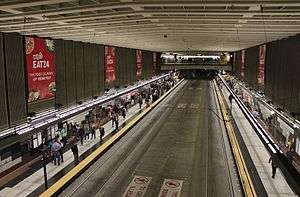 University Street station's platform level, viewed from one of the two mezzanines | |||||||||||||||||||||
| Location |
3rd Avenue & University Street Seattle, Washington | ||||||||||||||||||||
| Coordinates | 47°36′28.0″N 122°20′09.6″W / 47.607778°N 122.336000°WCoordinates: 47°36′28.0″N 122°20′09.6″W / 47.607778°N 122.336000°W | ||||||||||||||||||||
| Owned by | King County Metro | ||||||||||||||||||||
| Line(s) | Sound Transit Express, King County Metro | ||||||||||||||||||||
| Platforms | 2 side platforms | ||||||||||||||||||||
| Tracks | 2 | ||||||||||||||||||||
| Connections | RapidRide, King County Metro | ||||||||||||||||||||
| Construction | |||||||||||||||||||||
| Structure type | Underground | ||||||||||||||||||||
| Parking | Pay parking nearby | ||||||||||||||||||||
| Disabled access | Yes | ||||||||||||||||||||
| History | |||||||||||||||||||||
| Opened | September 15, 1990 | ||||||||||||||||||||
| Rebuilt | 2005–2007 | ||||||||||||||||||||
| Traffic | |||||||||||||||||||||
| Passengers | 5,565 daily boardings (2017; Link only)[1] | ||||||||||||||||||||
| Services | |||||||||||||||||||||
| |||||||||||||||||||||
University Street is a light rail and bus station that is part of the Downtown Seattle Transit Tunnel in Seattle, Washington. The station is located under 3rd Avenue at University Street, between Westlake and Pioneer Square stations. It is served by the Central Link, part of Sound Transit's Link light rail system, as well as buses from King County Metro and Sound Transit Express.
The station consists of two side platforms situated under street level, with two mezzanines connecting to the surface. It was designed in the style of high-tech architecture and includes several pieces of public art added during construction and later additions. The transit tunnel opened on September 15, 1990, and was used exclusively by buses until 2009. Along with all other stations in the transit tunnel, University Street station was closed from 2005 to 2007 for a major renovation to accommodate light rail. Link light rail service to the station began on July 18, 2009. Trains and buses serve the station twenty hours a day on most days; the headway between light rail trains is six minutes during peak periods, with less frequent service at other times.
Location
University Street station is located under 3rd Avenue between Union and Seneca streets in Downtown Seattle;[2] the area is part of the Metropolitan Tract, an area of downtown that is owned by, and was originally home to, the University of Washington.[3] The area surrounding the station primarily consists of high-rise office buildings and some mixed-use development, providing 102,194 jobs and housing a population of 13,813 within a 1⁄2 mile (0.8 km) of 3rd Avenue and University Street.[4] Major buildings in the immediate vicinity of University Street station include Benaroya Hall and 1201 Third Avenue (formerly Washington Mutual Tower) on the west side of the station and the historic Seattle Tower and Cobb Building on the east side. The Seattle Art Museum and the Harbor Steps are located two blocks west of the station at the intersection near 1st Avenue, above the Seattle Waterfront and Seattle Aquarium.[5] The 5th Avenue Theatre, Seattle Central Library, Rainier Square shopping center, and Union Square are all located east of the station along 5th Avenue.[2][6][7]
History
Early proposals
The Metropolitan Tract, historically the northern boundary of downtown Seattle during its early decades, was offered for development shortly after the University of Washington moved its campus to the north side of Portage Bay (modern day University District) in 1895. The university's Board of Regents voted to lease the land to private developers in 1902, beginning a construction boom in the area under the direction of the Metropolitan Building Company.[8] In 1911, Virgil Bogue presented a comprehensive plan for the city of Seattle, including a rapid transit system centered around a "trunk" subway under 3rd Avenue, passing through Downtown and the Metropolitan Tract, towards a new civic center in modern-day Belltown.[9][10] The plan was rejected by voters on March 5, 1912,[11] and the 3rd Avenue subway was unsuccessfully proposed twice in the 1920s.[12][13]
In the late 1960s, the Forward Thrust Committee put forward a ballot measure to fund a rapid transit system in the Seattle metropolitan area, including a downtown subway under 3rd Avenue with a station between Seneca and Spring streets.[14][15][16] The ballot measure, requiring a supermajority to support bonding to augment $385 million in local funding with $765 million from the Urban Mass Transportation Administration, failed to reach the 60 percent threshold in 1968 and again during a second vote in 1970.[17][18] The failure of the Forward Thrust ballot measures led to the creation of Metro Transit in 1972, operating bus service across King County.[19]
Bus tunnel
Metro Transit began planning a bus tunnel through downtown Seattle in the 1970s, to be eventually converted to use by light rail trains. Metro approved the construction of a bus tunnel under 3rd Avenue in 1983,[20] and chose the intersection of 3rd Avenue and University Street as the site of one of the tunnel's five stations.[21] The station at University Street, replacing two separate stations at Union and Madison streets, would be excavated cut-and-cover and be completed by late 1989.[22][23]
Excavation of the downtown bus tunnel began in early 1987, and construction reached the University Street area later that year.[24] The twin tunnel boring machines used to excavate the tunnel reached University Street in October 1987, and continued north towards Westlake station.[25][26] In December, Metro agreed to pay $2.4 million to real estate developer Marathon Company for use of a city block they owned adjacent to the station for equipment staging and storage, delaying the planned construction of office buildings on the site.[27] During excavation and construction of the University Street tunnel station, cracks and minor settling were found in the historic Seattle Tower, located nearby.[25] The ground around the tower was later stabilized to prevent additional settlement,[26] and was renovated with private funding in 1990.[28]
In March 1989, the first buses were tested in the tunnel; University Street station was only 75 percent complete, and buses had to drive under scaffolding and construction equipment while passing through the station.[29] Tunnel construction was completed in June 1990,[30] and a soft opening for University Street station was held on August 9, 1990.[31] Bus service in the Downtown Seattle Transit Tunnel began on September 15, 1990, with several Metro bus routes moved into the tunnel from surface streets.[32] All service on routes using the tunnel was operated by dual-mode buses, which operated as diesel buses outside the tunnel and electrically, as trolleybuses, when inside the tunnel. During its early months, University Street and other stations were affected by serious water leaks, which splashed water onto walkways during the tunnel's first winter in operation. The leaks were later fixed by Metro contractors.[33][34]
In 1994, the Seattle Symphony selected a city block adjacent to University Street station, used during tunnel construction for equipment staging and storage, as the site of their new concert hall.[35] The building, later named Benaroya Hall, required the two-year closure of the station's 2nd Avenue entrance beginning in 1996.[36] The entrance was re-opened in 1998, at the same time the new hall was inaugurated.[37]
Light rail
In the early 1990s, a regional transit authority (RTA) was formed to plan and construct a light rail system for the Seattle area. After an unsuccessful attempt in 1995, regional voters passed a $3.9 billion plan to build light rail under the RTA in 1996.[38] The downtown transit tunnel had already been planned for eventual light rail use and was built with tracks that would be incorporated into the initial system.[39][40] The RTA, later renamed Sound Transit, approved the tunnel as part of the route of its initial light rail line in 1999.[41] Ownership of the tunnel, including its stations, was transferred to Sound Transit in 2000 but returned two years later to King County Metro under a joint-operations agreement.[42][43]
The downtown transit tunnel closed on September 23, 2005, for a two-year, $82.7 million renovation to accommodate light rail vehicles. The renovation included the installation of new rails, a lowered roadbed at stations for level boarding, new signalling systems and emergency ventilation.[44][45] The tunnel reopened on September 24, 2007,[46] and Link light rail service began on July 18, 2009, from Westlake station to Tukwila International Boulevard station.[47][48]
In 2019, the downtown transit tunnel is planned to lose its bus service due to construction at Convention Place station. The tunnel will become served exclusively by light rail trains, which will include expanded service to Northgate in 2021.[49][50]
Naming
University Street station is named after University Street, itself named for the original campus of the University of Washington before it moved in 1895.[3] Metro discussed renaming the station for the Seattle Art Museum after it moved to the area in 1991, but took no action.[51]
In 2012, Sound Transit adopted names for light rail stations in the University District, near the current University of Washington campus, including "University of Washington" and "U District" stations.[52] The similarity between the three stations' names has led to public confusion, and calls to rename University Street station after Benaroya Hall or the Seattle Symphony.[53][54]
Station layout
| Street Level | Exits/Entrances | |
| Mezzanine | Ticket vending machines, to Exits/Entrances | |
| Platform level |
Side platform, doors will open on the right | |
| Northbound | ← Central Link toward University of Washington (Westlake) | |
| ← Bus Bay A (41, 74) northbound toward Interstate 5 (Westlake) | ||
| ← Bus Bay A (255) eastbound toward State Route 520 (Westlake) | ||
| Southbound | → Central Link toward Angle Lake (Pioneer Square) → | |
| → Bus Bay C (101, 102, 150) southbound toward SODO Busway (Pioneer Square) → | ||
| → Bus Bay D (550) eastbound toward Interstate 90 (Pioneer Square) → | ||
| Side platform, doors will open on the right | ||
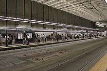
University Street station was designed in a high-tech motif to complement the modernist architecture found in 1980s-era office buildings in the adjacent Financial District; architectural elements were used to create the desired atmosphere in the station, including linear stainless steel light fixtures over the platforms, glass railings on the mezzanines, and colorful granite to highlight platform benches and information signs.[2][55] The station has two side platforms located below two mezzanines at the north and south ends of the station box: the north mezzanine is accessible through the parking garage of the Cobb Building at 3rd Avenue and Seneca Street as well as the west side of Benaroya Hall at 2nd Avenue and University Street, connected through a level walkway underneath the venue; the south mezzanine is accessible from a single entrance located in 1201 Third Avenue near 3rd Avenue and Seneca Street.[2] University Street station is approximately 570 feet (170 m) long, 70 feet (21 m) wide, and 60 to 70 feet (18 to 21 m) deep.[56]
The station is situated above the Great Northern Tunnel, a century-old rail tunnel, which passes under with a clearance of approximately 15 feet (4.6 m).[57] Both tunnels factored into the architecture of nearby Benaroya Hall, which has an auditorium that rests on rubber bearings to insulate from vibrations and a 6-foot-thick (1.8 m) concrete slab to minimize sound.[37]
Art
University Street station, like other stations in the downtown transit tunnel, is furnished with several pieces of public art that is integrated into its design by architect Mark Spitzer and lead artist Vicki Scuri.[55]
"The Beltline", designed by Scuri, runs along the platform and consists of colored granite arranged in patterns that highlight passenger amenities, including information panels and benches. The benches themselves have computer-generated dot matrix patterns sandblasted into the seats.[55][58] Some of the granite originally purchased for use in "The Beltline" originated in South Africa, then under a Metro-sanctioned boycott over its Apartheid policies; the discovery fueled a minor scandal that resulted in the resignation of Metro's executive director, while the granite would be replaced with another type.[59]
At the south mezzanine is Robert Teeple's "The Southern Lights", a series of fourteen LED screens that show animated symbols and phrases in a commentary on the increasing influence of computers in human life. The symbols range from human faces to animals and astrological signs;[58] the phrases, displayed in both English and Spanish, are randomly generated from using sets of four words that allow for 1.2 million possible combinations.[31][55] The north mezzanine has "The Northern Lights" by Bill Bell, a series of 24 embedded lights that form patterns when the eyes of viewers move rapidly from side to side. The patterns include images related to transportation and finance, including trolleys, airplanes, coins and the dollar sign.[55][58]
Two of the station's entrances and stairways are home to the silhouettes of and sentence-long quotes from A.H. Albertson, architect of the nearby Seattle Tower, and humanitarian activist Flo Ware.[2][55] At the corner of 3rd Avenue and University Street is a 14-foot-tall (4.3 m) pendulum clock known as "Hickory-Dickory Dock Clock", designed by Heather Ramsay with references to the nursery rhyme "Hickory Dickory Dock", including a brass mouse running up its side.[55]
The Benaroya Hall entrance to University Street station, built in 1998 for the new venue, is decorated with a series of art pieces by Erin Shie Palmer known collectively as the "Temple of Music".[60] The walkway's walls are sandblasted with images that begin as an abstract musical score derived from Robert Fludd's "Temple of Music" and morph into pixellated patterns as it approaches the station mezzanine. The walkway's handrails are etched with Braille text and voiceprints, and end in sculpted depictions of a violin and a microphone.[55][61]
The station's pictogram, a pair of theater spectacles, represents the neighborhood's connections to the arts. It was created in 2009 by Christian French as part of the Stellar Connections series and its points represent nearby destinations, including Benaroya Hall, the Seattle Art Museum, the Central Library, and the 5th Avenue Theatre.[62]
Services
.jpg)
University Street station is part of the Downtown Seattle Transit Tunnel and is located one stop south of Westlake station and two stops north of International District/Chinatown stations, the tunnel's southern terminus The tunnel is also part of Sound Transit's Central Link line, which runs from the University of Washington campus to Downtown Seattle, the Rainier Valley and Seattle–Tacoma International Airport. University Street is the twelfth northbound station from Angle Lake station and third southbound station from University of Washington station, situated between Pioneer Square and Westlake stations. Central Link trains serve University Street twenty hours a day on weekdays and Saturdays, from 5:00 am to 1:00 am, and eighteen hours on Sundays, from 6:00 am to 12:00 am; during regular weekday service, trains operate roughly every six to ten minutes during rush hour and midday operation, respectively, with longer headways of fifteen minutes in the early morning and twenty minutes at night. During weekends, Central Link trains arrive at University Street station every ten minutes during midday hours and every fifteen minutes during mornings and evenings. The station is approximately 35 minutes from SeaTac and three minutes from Westlake.[63][64] In 2017, an average of 5,565 passengers boarded Link trains at University Street station on weekdays.[1]
In addition to light rail service, University Street station and the Downtown Seattle Transit Tunnel are served by six King County Metro bus routes and one Sound Transit Express bus route. The bus routes are divided into three bays by their outbound direction: Bay A is served by three routes heading north toward Northgate and the University District and east towards Kirkland (routes 41, 74, and 255); Bay C is served by three routes heading south through the SODO Busway toward Kent and Renton (routes 101, 102, and 150); and Bay D is served by one route heading east via Interstate 90 to Bellevue (Sound Transit Express route 550).[65]
University Street station is adjacent to four surface bus stops on 3rd Avenue near its entrances, served by several King County Metro routes and three RapidRide lines: the C Line to West Seattle and South Lake Union, the D Line to Ballard and the E Line on Aurora Avenue North to Shoreline.[66] The area is also served by two east–west routes (routes 2 and 12) that travel towards First Hill and eastern Seattle.[65]
During closures of the Downtown Seattle Transit Tunnel and University Street station, tunnel buses are rerouted onto the surface; southbound buses stop at 2nd Avenue and Seneca Street, while northbound buses stop on 4th Avenue between University and Union streets. King County Metro also runs a special route, the Route 97 Link Shuttle, between all Link light rail stations during service disruptions, stopping on 3rd Avenue between University and Union streets to serve the station.[67]
References
- 1 2 "Q4 2017 Service Delivery Quarterly Performance Report" (PDF). Sound Transit. February 22, 2018. Archived (PDF) from the original on February 23, 2018. Retrieved February 22, 2018.
- 1 2 3 4 5 Transit Tunnel: University Street Station (PDF) (Map). King County Metro Transit. September 2007. Archived (PDF) from the original on April 12, 2015. Retrieved May 21, 2017.
- 1 2 Banel, Feliks (December 14, 2012). "UW 150: Downtown Real Estate Helps Fund University". KUOW. Archived from the original on February 26, 2018. Retrieved May 21, 2017.
- ↑ Growing Transit Communities Oversight Committee (October 2013). "University Street: Light Rail/Bus" (PDF). The Growing Transit Communities Strategy. Puget Sound Regional Council. Retrieved May 21, 2017.
- ↑ Lindblom, Mike (May 21, 2009). "Tunnel two-step: It may take buses longer to clear shared tunnel". The Seattle Times. p. A1. Archived from the original on September 5, 2017. Retrieved May 21, 2017.
- ↑ Downtown Seattle (PDF) (Map). Visit Seattle. 2017. Archived from the original (PDF) on 2017-09-05. Retrieved May 21, 2017.
- ↑ Sipe, Tyler; Wasson, Lindsey (December 12, 2016). "Transit Tourism: Explore Seattle by Link light rail". The Seattle Times. Archived from the original on December 16, 2016. Retrieved May 21, 2017.
- ↑ "No Finer Site: The University of Washington's Early Years On Union Bay". University of Washington Libraries Special Collections. 1995. Archived from the original on June 22, 2017. Retrieved May 21, 2017.
- ↑ Bogue, Virgil (1911). "Appendix No. III—Proposed Rapid Transit System". Plan of Seattle: Report of the Municipal Plans Commission. Seattle, Washington: Lowman & Hanford. p. 180. OCLC 1440455. Archived from the original on August 19, 2014. Retrieved May 21, 2017 – via Google Books.
- ↑ "Municipal Plans Embrace Great Third Avenue Improvements". The Seattle Times. November 12, 1911. p. 25.
- ↑ Crowley, Walt (September 17, 1972). "Virgil Bogue's plan: Seattle that might have been". The Seattle Times. pp. 8–9.
- ↑ "2008 Find of the Month Archive: 1920 rapid transit plan". Seattle Municipal Archives. June 2008. Archived from the original on September 24, 2015. Retrieved May 21, 2017.
- ↑ Trimble, William Pitt (1926). Seattle Rapid Transit Report to the City Planning Commission. Seattle Planning Commission. OCLC 14264109.
- ↑ De Leuw, Cather & Company (October 30, 1967). "Chapter 8: Engineering Studies and Analyses". Report on a Comprehensive Public Transportation Plan for the Seattle Metropolitan Area. Municipality of Metropolitan Seattle. p. 93. OCLC 74314.
- ↑ De Leuw, Cather & Company (February 19, 1970). "Chapter 1: Recommended Public Transportation Plan". The Rapid Transit Plan for the Metropolitan Seattle Area. Municipality of Metropolitan Seattle. p. 15. OCLC 120953.
- ↑ Lane, Bob (April 29, 1970). "Choice of Third Avenue Transit Line Explained". The Seattle Times. p. A8.
- ↑ McRoberts, Patrick (January 1, 1999). "King County voters on Forward Thrust bonds approve stadium and aquarium and nix transit on February 13, 1968". HistoryLink. Archived from the original on October 2, 2016. Retrieved May 21, 2017.
- ↑ "Voters reject rail transit plan and three other Forward Thrust bond proposals on May 19, 1970". HistoryLink. September 19, 2002. Archived from the original on October 2, 2016. Retrieved May 21, 2017.
- ↑ "Milestones—The 1970s". King County Metro. Archived from the original on May 7, 2017. Retrieved May 21, 2017.
- ↑ Gough, William (November 4, 1983). "Metro Council OK's downtown transit tunnel". The Seattle Times. p. B1.
- ↑ Nogaki, Sylvia (February 18, 1984). "Metro envisions city bus subway in 5 years". The Seattle Times. p. A6.
- ↑ Nogaki, Sylvia (September 13, 1984). "Panel urges boring of Metro tunnel — and 5 stations". The Seattle Times. p. B2.
- ↑ "Panel picks sites for tunnel stations". The Seattle Times. November 1, 1984. p. C6.
- ↑ Lane, Bob (July 16, 1987). "Tunnel bidding too high for Metro; engineers to consider redesign at lower cost". The Seattle Times. p. E1.
- 1 2 Lane, Bob (January 27, 1988). "Landmark tower slightly cracked in tunnel-digging". The Seattle Times. p. E1.
- 1 2 Lane, Bob (February 12, 1988). "Almost finished: 3 blocks of tunnel". The Seattle Times. p. D1.
- ↑ Healy, Tim (December 26, 1987). "Marathon delays project again; Metro expected to use property". The Seattle Times. p. A16.
- ↑ Goodnow, Cecelia (January 1, 1990). "Ring in the old: The 1929 Seattle Tower is being restored to its original glory". Seattle Post-Intelligencer. p. C1.
- ↑ Lane, Bob (March 16, 1989). "First run: buses roll through the tunnel". The Seattle Times. p. A1.
- ↑ Lane, Bob (June 7, 1990). "Deafening silence: Bus tunnel's done". The Seattle Times. p. B1. Archived from the original on March 3, 2016. Retrieved May 21, 2017.
- 1 2 Duncan, Don (August 10, 1990). "Metro shows off tunnel vision—High-tech artwork dazzles thousands at University Street bus station". The Seattle Times. p. B1. Archived from the original on October 3, 2016. Retrieved May 21, 2017.
- ↑ Rosenwald, Lonnie (September 15, 1990). "Seattle opens glitzy new bus tunnel today". The Spokesman-Review. Spokane, Washington: Cowles Publishing Company. p. A9. Retrieved May 21, 2017 – via Google News Archive.
- ↑ Anderson, Rick (November 14, 1990). "Bus tunnel users find no refuge from soggy Seattle". The Seattle Times. p. D1. Archived from the original on February 26, 2018. Retrieved May 21, 2017.
- ↑ Lane, Bob (September 16, 1991). "Bus tunnel rolls into second year". The Seattle Times. p. B1. Archived from the original on February 2, 2017. Retrieved May 21, 2017.
- ↑ Bargreen, Melinda (July 24, 1994). "Choice of site for concert hall raises questions". The Seattle Times. p. M1. Archived from the original on February 26, 2018. Retrieved May 21, 2017.
- ↑ "Bus-tunnel entrance to be closed". The Seattle Times. March 27, 1996. p. B2. Archived from the original on March 3, 2016. Retrieved May 21, 2017.
- 1 2 Bargreen, Melinda (June 21, 1998). "Benaroya Hall: Sound is everything". The Seattle Times. p. A1. Archived from the original on February 26, 2018. Retrieved May 21, 2017.
- ↑ Schaefer, David (November 6, 1996). "Voters back transit plan on fourth try". The Seattle Times. p. A1. Archived from the original on March 3, 2016. Retrieved May 21, 2017.
- ↑ Hamilton, Charles (November 6, 2006). "Sound Transit (King, Pierce, and Snohomish counties)". HistoryLink. Archived from the original on July 28, 2017. Retrieved May 21, 2017.
- ↑ Pryne, Eric (October 13, 2005). "Bus-tunnel error years ago is costly in shutdown today". The Seattle Times. p. A1. Archived from the original on February 2, 2017. Retrieved May 21, 2017.
- ↑ "Sound Transit Board achieves historic milestone by selecting route for central Link light rail" (Press release). Sound Transit. November 18, 1999. Archived from the original on July 28, 2017. Retrieved May 21, 2017.
- ↑ Pryne, Eric (June 25, 2002). "Sound Transit, county agree to bus-tunnel plan". The Seattle Times. p. B1. Archived from the original on February 2, 2017. Retrieved May 21, 2017.
- ↑ Pryne, Eric (May 12, 2002). "The bus tunnel tug-of-war". The Seattle Times. p. A1. Archived from the original on February 2, 2017. Retrieved May 21, 2017.
- ↑ Gilmore, Susan (September 23, 2005). "Bus tunnel shuts down tonight for 2 years". The Seattle Times. p. A1. Archived from the original on February 2, 2017. Retrieved May 21, 2017.
- ↑ "Whats, whys of $82.7 million tunnel project". The Seattle Times. September 23, 2005. p. A15. Archived from the original on February 2, 2017. Retrieved May 21, 2017.
- ↑ Gilmore, Susan (September 25, 2007). "Reopening of downtown Seattle bus tunnel goes smoothly". The Seattle Times. Archived from the original on February 2, 2017. Retrieved May 21, 2017.
- ↑ "Link light rail launches new era of mobility for central Puget Sound" (Press release). Seattle, Washington: Sound Transit. July 18, 2009. Archived from the original on March 3, 2016. Retrieved May 21, 2017.
- ↑ Lindblom, Mike (July 20, 2009). "Light-rail trains run smoothly, if not to capacity, on first day". The Seattle Times. p. B1. Archived from the original on November 28, 2016. Retrieved May 21, 2017.
- ↑ Lindblom, Mike (January 27, 2017). "For thousands, light rail could be the only way through downtown Seattle next year". The Seattle Times. p. B1. Archived from the original on May 18, 2017. Retrieved May 21, 2017.
- ↑ Lindblom, Mike (June 25, 2017). "Reprieve for tunnel riders, but cascading projects to multiply Seattle's traffic woes". The Seattle Times. p. B1. Archived from the original on June 25, 2017. Retrieved June 26, 2017.
- ↑ Tarzan Ament, Deloris (October 11, 1991). "Momentum is building towards Dec. 5 SAM opening". The Seattle Times. p. D1.
- ↑ "Sound Transit Motion No. M2012-36: Adopting Station and Facility Names for the North Link and University Link Projects (Staff Report)" (PDF). Sound Transit. June 28, 2012. Archived (PDF) from the original on September 9, 2016. Retrieved May 21, 2017.
- ↑ "Fixed This! Yes, that train will take you there". Crosscut.com. February 19, 2013. Archived from the original on February 26, 2018. Retrieved May 21, 2017.
- ↑ Radil, Amy (June 18, 2012). "Naming Light Rail Stations Not As Simple As It Seems". KUOW. Archived from the original on September 10, 2017. Retrieved August 16, 2015.
- 1 2 3 4 5 6 7 8 "University Street Station–a Touch of High-Tech". King County Metro. Archived from the original on September 9, 2015. Retrieved May 21, 2017.
- ↑ Laprade, William T.; Thompson, Steven R. (1989). "Engineering Geology of the Downtown Seattle Transit Project" (PDF). Engineering Geology in Washington: Volume II. Washington State Department of Natural Resources: 667. OCLC 763131412. Archived (PDF) from the original on July 30, 2017. Retrieved May 23, 2017.
- ↑ Mapes, Lynda V. (December 10, 2011). "Tunnels: Seattle's boring past filled with thrills". The Seattle Times. Archived from the original on February 2, 2017. Retrieved May 21, 2017.
- 1 2 3 Mathieson, Karen (September 12, 1990). "Tunnel Visions: Bus labyrinth beneath Seattle spawns gallery". The Seattle Times. p. C1. Archived from the original on October 6, 2014. Retrieved May 21, 2017.
- ↑ Lane, Bob (March 10, 1989). "Report to Metro finds no cover-up on granite". The Seattle Times. p. C1.
- ↑ Updike, Robin (September 15, 1998). "An artist's symphony of images: Robert Rauschenberg leaves a visual 'echo' in Benaroya Hall's lobby". The Seattle Times. p. F1. Archived from the original on February 26, 2018. Retrieved May 21, 2017.
- ↑ "Art In & Around The Hall". Seattle Symphony. Archived from the original on April 27, 2017. Retrieved May 21, 2017.
- ↑ "Stellar Connections". Sound Transit. Archived from the original on June 12, 2010. Retrieved April 21, 2017.
- ↑ "Link light rail schedule". Sound Transit. June 6, 2015. Archived from the original on August 9, 2015. Retrieved May 23, 2017.
- ↑ "Expanded Metro bus service coming; Link light rail ramps up in downtown tunnel" (Press release). King County Metro. September 16, 2015. Archived from the original on November 20, 2015. Retrieved May 21, 2017.
- 1 2 Downtown Metro Service: Frequent Routes to Help You Get Around Downtown (PDF) (Map). King County Metro. September 2016. Archived (PDF) from the original on October 6, 2014. Retrieved May 21, 2017.
- ↑ 3rd Ave Boarding Locations (PDF) (Map). King County Metro. Archived (PDF) from the original on February 8, 2017. Retrieved May 21, 2017.
- ↑ Surface Street Bus Stops When the Downtown Seattle Transit Tunnel is Closed (PDF) (Map). King County Metro. Archived (PDF) from the original on October 7, 2014. Retrieved May 21, 2017.
External links
| Wikimedia Commons has media related to University Street (Link station). |