Umm Bab
| Umm Bab أم باب | |
|---|---|
| Settlement | |
 Umm Bab | |
| Coordinates: 25°12′35″N 50°48′48″E / 25.20972°N 50.81333°ECoordinates: 25°12′35″N 50°48′48″E / 25.20972°N 50.81333°E | |
| Country | Qatar |
| Municipality | Al-Shahaniya |
| Area | |
| • Total | 494.1 km2 (190.8 sq mi) |
| Population (2015)[1] | |
| • Total | 5,305 |
| • Density | 11/km2 (28/sq mi) |
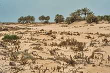
Umm Bab (Arabic: أم باب) is a settlement in Qatar, located in the municipality of Al-Shahaniya.[2] It used to be part of the Al Rayyan municipality and before that was administered by Al Jemailiya municipality before the latter was incorporated into Al Rayyan.[3] Umm Bab is also known as 'Palm Tree Beach' owing to a small cluster of palm trees situated on its beach.[4]
Aside from accommodating Qatar's first major non-oil related industry in the form of a cement processing facility which began operation in 1969,[5] there also exists minor oil and gas separation facilities within the settlement.[6]
Etymology
The settlement derived its name from local geographical features. Umm Bab translates to 'mother of gateway'. The 'gateway' portion of the name refers to a narrow path or opening in the area surrounded by two small hills which resemble a gateway.[7]
History

In 1948, shortly after the commencement of oil drilling operations in Dukhan, a housing village was built to the immediate south of Umm Bab to accommodate both Qatar Petroleum workers and locals of Umm Bab.[8] A road was built the same year to connect Umm Bab and Dukhan.[9] In 1961, the government inaugurated a boys school in the village. The housing village had approximately 50 houses by 1990, most of which belonged to members of the Al Murrah tribe who were employed by Qatar Petroleum.[8]
Geography
Situated in western Qatar, Umm Bab is only 25 km away from the industrial city of Dukhan. It is 85 km west of the capital of Doha, 142 km southwest of Al Khor, and 100 km northwest of Al Wakrah.[10]
Infrastructure
The Umm Bab Coastal Center was opened in May 2017 by The Ministry of Interior's General Directorate of Coasts and Borders Security. Included within this center is a seaport, administrative buildings, and a boat maintenance shop. It is intended to serve as the primary coastguard station for the directorate's Western District.[11]
Industry
Umm Bab is one of only two sites in Qatar from which large quantities of limestone and clay can be easily excavated, the other site being Umm Salal.[12] In 1965, the government capitalized on Umm Bab's rich natural resources by headquartering the Qatar National Cement Company in the area.[13] This decision also served as an impetus to develop Qatar's western region.[12]
The first processing of cement took place in 1969, and the factory received its water supply from Rawdat Rashed and its oil supply from Dukhan.[14]
Archaeology
The archaeological site of Asaila is near Umm Bab.[15] It was discovered by a French archaeological team that surveyed and excavated several sites in Qatar between 1976 and 1982.[16] By 1981, the team had excavated Asaila.[15] This site was revisited by a joint German-Qatari archaeological team which was formed in 2012. The artifacts recovered at the site indicate a human presence during the early Neolithic period, c. 8,000 years ago.[16] Several other archaeological sites have been discovered near Umm Bab.[17]
In July 2018, a resident alerted archaeologists to the first inland rock site in the country near Umm Bab. Rock samples were collected and are pending analysis on their dating.[18]
Demographics
As of the 2010 census, the settlement comprised 220 housing units[19] and 55 establishments.[20] There were 6,194 people living in the settlement, of which 97% were male and 3% were female. Out of the 6,194 inhabitants, 97% were 20 years of age or older and 3% were under the age of 20.[21] The literacy rate was 96.4%.
Employed persons made up 96% of the total population. Females accounted for 1% of the working population, while males accounted for 99% of the working population.[21]
| Year | Population |
|---|---|
| 1986[22] | 1,036 |
| 1997[23] | 1,829 |
| 2004[3] | 1,287 |
| 2010[2] | 6,194 |
| 2015[1] | 5,305 |
References
- 1 2 "2015 Population census" (PDF). Ministry of Development Planning and Statistics. April 2015. Retrieved 8 August 2017.
- 1 2 "2010 population census" (PDF). Qatar Statistics Authority. Retrieved 29 June 2015.
- 1 2 "2004 population census". Qatar Statistics Authority. Retrieved 1 July 2015.
- ↑ "Beaches". Qatar Tourism Authority. Archived from the original on 6 July 2015. Retrieved 1 July 2015.
- ↑ Looney, Robert E. (March 1990). "Structural Impediments to Industrialization in Qatar". Calhoun: The NPS Institutional Archive. p. 19. Retrieved 24 June 2018.
- ↑ "National Implementation Plan (NIP) for Stockholm Convention on Persistent Organic Pollutants (POPs)". Ministry of Municipality and Environment. p. 6. Retrieved 24 June 2018.
- ↑ Jacques LeBlanc (March 2008). "A fossil hunting guide to the tertiary formations of Qatar, Middle East".
- 1 2 Fahd Abdul Rahmn Hamad Al-Thani (1992). "The Spatial Impact of the Hydrocarbon Industry on Land and Sea Use in Qatar" (PDF). University of Durham; Durham e-Thesis. p. 148.
- ↑ Fahd Abdul Rahmn Hamad Al-Thani (1992). "The Spatial Impact of the Hydrocarbon Industry on Land and Sea Use in Qatar" (PDF). University of Durham; Durham e-Thesis. p. 138.
- ↑ Whelan, John (1983). Qatar, a MEED practical guide. London: Middle East Economic Digest. p. 160. ISBN 0950521191.
- ↑ "MoI opens Umm Bab Coastal Center". Qatar Tribune. 23 May 2017. Retrieved 6 July 2018.
- 1 2 Al-Kubaisi, Mohammed Ali M. (1984). Industrial development in Qatar: a geographical assessment (PDF). Durham E-Theses, Durham University. p. 151.
- ↑ "About the company" (in Arabic). Qatar National Cement Company. Retrieved 29 July 2015.
- ↑ Al-Kubaisi, Mohammed Ali M. (1984). Industrial development in Qatar: a geographical assessment (PDF). Durham E-Theses, Durham University. p. 152.
- 1 2 Qatar: Year Book 1980–81. Doha: Press and Publications Department, Ministry of Information. 1981. p. 74.
- 1 2 "World Heritage" (PDF). Vol. 72. UNESCO. June 2014. p. 83. Retrieved 5 July 2018.
- ↑ "World Heritage" (PDF). Vol. 72. UNESCO. June 2014. p. 80. Retrieved 5 July 2018.
- ↑ "Qatar Museums to resume excavation after summer to explore Qatar's history". The Peninsula. 23 July 2018. Retrieved 23 July 2018.
- ↑ "Housing units, by type of unit and zone (April 2010)" (PDF). Qatar Statistics Authority. Retrieved 7 August 2015.
- ↑ "Establishments by status of establishment and zone (April 2010)" (PDF). Qatar Statistics Authority. Retrieved 7 August 2015.
- 1 2 "Geo Statistics Application". Ministry of Development Planning and Statistics. Archived from the original on 11 September 2012. Retrieved 7 August 2015.
- ↑ "1986 population census" (PDF). Qatar Statistics Authority. Archived from the original (PDF) on 3 July 2015. Retrieved 2 July 2015.
- ↑ "1997 population census" (PDF). Qatar Statistics Authority. Archived from the original (PDF) on 29 May 2015. Retrieved 2 July 2015.
| Administrative zones | |
|---|---|
| Districts |
|
| Landmarks |
|