Ulysses, Pennsylvania
| Ulysses, Pennsylvania | |
|---|---|
| Borough | |
 Location of Ulysses in Potter County, Pennsylvania. | |
 Ulysses Location within the U.S. state of Pennsylvania  Ulysses Ulysses (the US) | |
| Coordinates: 41°54′10″N 77°45′40″W / 41.90278°N 77.76111°WCoordinates: 41°54′10″N 77°45′40″W / 41.90278°N 77.76111°W | |
| Country | United States |
| State | Pennsylvania |
| County | Potter |
| Settled | 1831 |
| Incorporated (borough) | 1872 |
| Area[1] | |
| • Total | 4.05 sq mi (10.50 km2) |
| • Land | 4.05 sq mi (10.50 km2) |
| • Water | 0.00 sq mi (0.00 km2) |
| Population (2010) | |
| • Total | 621 |
| • Estimate (2016)[2] | 595 |
| • Density | 146.77/sq mi (56.67/km2) |
| Time zone | Eastern (EST) |
| • Summer (DST) | EDT |
| ZIP code | 16948 |
| Area code(s) | 814 |
| FIPS code | 42-78240 |
Ulysses is a borough in Potter County, Pennsylvania, United States. The population was 623 in 2012. The town has been known nationally for its white supremacist activities and the practice of Odinism for a century. It hosted the World Aryan Congress in the 2000s. The Washington Post described the borough's tumultuous history in a 2018 article.[3]
History
When it was first settled in 1831, Ulysses was named Lewisville after Orange Lewis, an early settler and prominent farmer who later became justice of the peace and county treasurer. But the post office and newspaper had always called the town Ulysses, and eventually, in 1968, the town itself was officially renamed Ulysses.[4]
Geography
Ulysses is located at 41°54′10″N 77°45′40″W / 41.90278°N 77.76111°W (41.902838, -77.761017).[5]
According to the United States Census Bureau, the borough has a total area of 4.0 square miles (10 km2), all of it land.
Demographics
| Historical population | |||
|---|---|---|---|
| Census | Pop. | %± | |
| 1870 | 226 | — | |
| 1880 | 365 | 61.5% | |
| 1890 | 459 | 25.8% | |
| 1900 | 619 | 34.9% | |
| 1910 | 579 | −6.5% | |
| 1920 | 526 | −9.2% | |
| 1930 | 514 | −2.3% | |
| 1940 | 488 | −5.1% | |
| 1950 | 495 | 1.4% | |
| 1960 | 590 | 19.2% | |
| 1970 | 590 | 0.0% | |
| 1980 | 654 | 10.8% | |
| 1990 | 653 | −0.2% | |
| 2000 | 684 | 4.7% | |
| 2010 | 621 | −9.2% | |
| Est. 2016 | 595 | [2] | −4.2% |
| Sources:[6][7][8] | |||
As of the census[7] of 2000, there were 684 people, 268 households, and 183 families residing in the borough. The population density was 170.9 people per square mile (66.0/km²). There were 296 housing units at an average density of 73.9 per square mile (28.6/km²). The racial makeup of the borough was 98.68% White, 0.73% Native American, 0.15% Pacific Islander, and 0.44% from two or more races. Hispanic or Latino of any race were 0.58% of the population.
There were 268 households, out of which 31.3% had children under the age of 18 living with them, 52.6% were married couples living together, 12.3% had a female householder with no husband present, and 31.7% were non-families. 26.5% of all households were made up of individuals, and 13.8% had someone living alone who was 65 years of age or older. The average household size was 2.55 and the average family size was 3.07.
In the borough the population was spread out, with 29.2% under the age of 18, 9.4% from 18 to 24, 25.3% from 25 to 44, 19.7% from 45 to 64, and 16.4% who were 65 years of age or older. The median age was 33 years. For every 100 females there were 87.4 males. For every 100 females age 18 and over, there were 82.0 males.
The median income for a household in the borough was $23,971, and the median income for a family was $27,813. Males had a median income of $27,292 versus $20,694 for females. The per capita income for the borough was $11,602. About 25.6% of families and 34.2% of the population were below the poverty line, including 56.3% of those under age 18 and 11.4% of those age 65 or over.
References
- ↑ "2016 U.S. Gazetteer Files". United States Census Bureau. Retrieved Aug 14, 2017.
- 1 2 "Population and Housing Unit Estimates". Retrieved June 9, 2017.
- ↑ Pogrund, Gabriel (July 28, 2018). "How white supremacists split a quiet Rust Belt town". The Washington Post. Retrieved July 29, 2018.
- ↑ C. Paul Keller. "Ulysses". Potter County Visitor's Association. Retrieved 2007-05-07.
- ↑ "US Gazetteer files: 2010, 2000, and 1990". United States Census Bureau. 2011-02-12. Retrieved 2011-04-23.
- ↑ "Census of Population and Housing". U.S. Census Bureau. Retrieved 11 December 2013.
- 1 2 "American FactFinder". United States Census Bureau. Retrieved 2008-01-31.
- ↑ "Incorporated Places and Minor Civil Divisions Datasets: Subcounty Resident Population Estimates: April 1, 2010 to July 1, 2012". Population Estimates. U.S. Census Bureau. Archived from the original on 17 June 2013. Retrieved 11 December 2013.
Municipalities and communities of Potter County, Pennsylvania, United States | ||
|---|---|---|
| Boroughs | 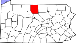 | |
| Townships | ||
| CDPs | ||
| Unincorporated communities | ||