Udgir
| Udgir उदयगीरी | |
|---|---|
| City | |
| Nickname(s): Udaygiri Nagari | |
 Udgir Location in Maharashtra, India | |
| Coordinates: 18°23′46″N 77°07′03″E / 18.39611°N 77.11750°ECoordinates: 18°23′46″N 77°07′03″E / 18.39611°N 77.11750°E | |
| Country |
|
| State | Maharashtra |
| District | Latur |
| Taluka | Udgir |
| Government | |
| • Type | Municipal Council |
| • Body | Udgir Nagar Parishad |
| • Municipal President | Baswaraj Bagbande |
| Area | |
| • Total | 736.26 km2 (284.27 sq mi) |
| Elevation | 632 m (2,073 ft) |
| Population (2011)[1] | |
| • Total | 3,11,066 |
| • Density | 422/km2 (1,090/sq mi) |
| Demonym(s) | Udgirkar |
| Languages | |
| • Official | Marathi |
| Time zone | UTC+5:30 (IST) |
| PIN | 413517 |
| Telephone code | 02385 |
| Distance from Latur | 65 kilometres (40 mi) NW (land) |
| Lok Sabha constituency | Latur |
| Vidhan Sabha constituency | Udgir[2] |
| Website |
latur |
Udgir or Udaygiri is a city with a municipal council in Latur district in the Indian States and territories of India of Maharashtra. It is located in the Marathwada division of the state (one of the divisions of Maharashtra state based on geographical conditions).[3] The city is located very near to the Karnataka border. The town is famous for the historical Udgir Fort, also known as Udaygiri Fort. The town and nearby villages rely on Agriculture outcomes which serves as a major source of income for living.
Demographics
Udgir is a Taluka located in Latur District of Maharashtra. It is one of the 10 Talukas of Latur District. There are 98 villages and 2 towns in Udgir Taluka.
As per the Census India 2011, Udgir Taluka has 56,806 households, population of 3,11,066 of which 1,61,568 are males and 1,49,498 are females. The population of children between age 0-6 is 41,456 which is 13.33% of total population.
The sex-ratio of Udgir Taluka is around 925 compared to 929 which is average of Maharashtra state. The literacy rate of Udgir Taluka is 68.71% out of which 74.37% males are literate and 62.6% females are literate. The total area of Udgir is 736.26 sq.km with population density of 422 per sq.km.
Out of total population, 64.06% of population lives in Urban area and 35.94% lives in Rural area.
The main source of income for Udgir Taluka comes from agriculture, shops and small scale industries. This town is popular for its inventory in food grains which is the result of high grain crop production in nearby villages.
History
.jpg)
Udgir is famous for the historic war between the Marathas and the Nizam, led by Sadashivrao Bhau who defeated Nizam in 1759 when the treaty of Udgir was signed. Marathas won a convincing victory in the Battle of Udgir under the able leadership of brave warrior Sadashivrao Bhau. Later it prompted Peshwe (Peshwas) of Pune to promote/elevate and designate him as Chief Commander of the Maratha Army for the Third Battle of Panipat fought in 1761. Nevertheless, it was part of Nizam until 1948 and State of Hyderabad between 1948 and 1956 before annexing to Bombay State with entire Marathwada.
Shri Hawagi Swami temple one of the oldest temple of Hawagi Swami Maharaj, and Hazrath Khaja Sadharudeen Basha Dargha Sherif, which about 400 years old; are also located in the town.
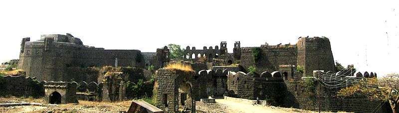
Udgir Fort
The fort of Udgir still stands in all its glory, speaking volumes about the Indian history and Indian culture. The fort is bounded by a 40-foot-deep trench, as the fort is built at the ground level. In the fort are several palaces, Durbar halls and the grave of Udaygiri Maharaj which is 60 feet below ground level. It is believed that the Udgir fort has a direct deep underground subway connecting with Bhalki and the Bidar forts.
Education
Udgir is known for its old and well established educational institutions.
List of Schools:
- Al-ameen High School , Udgir
- Lal Bahadur Shastri Vidyalaya High School, Udgir
- Jamhoor High School, Udgir
- Deccan High School, Udgir
- Vidya Vardhini High School, Udgir
- Vidya Vardhini English School, Udgir
- Zila Parishad (boys) High School, Udgir
- Shymlal Smarak Vidyalaya High School, Udgir
- Dr. A. P. J. Abdul-Kalam High School, Udgir
- Sane Guruji Primary & High school, Udgir
- Akshar Nandan Marathi School, Udgir
- Anandi Public School, Udgir
- The Methodist English School, Udgir
- Madrasa Arabiyya Qasim-ul-Uloom, Udgir
- Al Hilal Urdu Girls High School,Udgir
- Sane Guruji Primary & High school, Udgir
- Uday Highschool, Udgir
- Shri Chhatrapati Shahu Vidyayalay, Udgir
- Times Public School,Udgir
- Sangram Smarak Vidyalaya, Udgir
- Baghirath High School, Udgir
- Dr. Syed Mohammed Memorial Primary School, Udgir
- Rajarshi Shahu Vidyalaya, Udgir
- Gnanodaya High School, Udgir
- Bright Star High School, Udgir
- Merry Daffodils English High School,Udgir
List of Colleges:
- Shivaji Mahavidyalay, Udgir
- Maharashtra Udaygiri College, Udgir
- Government I.T.I College, Udgir
- Dhanvantari Ayurvedic College, Udgir
- Hawgiswamy College of Arts, Science & Commerce, Udgir
- Lal Bahadur Shastri College of Polytechnic, Udgir
- Al-Ameen College of Arts, Udgir
- Jamhoor College of Arts, Udgir
- College of Veterinary and Animal Sciences (COVAS), Udgir:Government College, Constituent college of Maharashtra Animal and Fishery Sciences University (MAFSU), Nagpur
- College of Fishery Science (COFS), Udgir:Government College, Constituent college of Maharashtra Animal and Fishery Sciences University (MAFSU), Nagpur
- College of Dairy Technology (CDT), Udgir:Government College, Constituent college of Maharashtra Animal and Fishery Sciences University (MAFSU), Nagpur
- Swami Vivekanand College of Information & Technology, Udgir
- Dhanvantari Ayurvedic College, Udgir
- Maharashtra Udaygiri College of Engineering & Management, Udgir
- Rajiv Gandhi Polytechnic College, Udgir[www.rgpudgir.org]
- Shyamlal Junior College, Udgir
- Matrabhumi College, Udgir
- College Of Food Technology, Udgir
- Mauli Shikshan Prasark Mandal College of Pharmacy, Udgir
- College Of Agriculture, Dongarshelki Tanda, Udgir (Affiliated to V.N.M.K.V) College
Connectivity
Railways: Udgir Railway station is connected by trains available from and to Hyderabad, Aurangabad, Pune, Mumbai, Bangalore, Latur, Nanded, Osmanabad, Kakinada and Tirupati. Udgir comes under the South Central Railways zone of the Indian Railways. It is part of Nanded Division of the South Central Railways zone .
Roadways: Udgir is well connected by roads with all major villages and cities in Maharashtra and nearby states. Maharashtra State Bus Services commonly known as ST or Maharashtra State Road Transport Corporation operate day and night buses in and out of the town, providing easy, overnight and safe connectivity. Inter state government transport buses are also available from and to Bidar and Hyderabad.
Private Buses also run daily from and to major places like Mumbai and Pune.
Airways: The nearest major domestic and international airport, which is at 225 Kilometres, from Udgir is Rajiv Gandhi International Airport, Hyderabad, Telangana State, India.
Banks
List of Banks:
- State Bank of India
- Bank of Maharashtra
- Bank Of India
- HDFC Bank
- Latur DCC Bank Ltd
- DCB Bank
- Latur Urban Co-Operative Bank
- Solapur Janta Co-operative Bank
- ICICI Bank
- Axis Bank
- Bank of Baroda
- Union Bank of India
- Central Bank of India
- Maharashtra Gramin Bank
- Udgir Urban Co-Operative Bank
- Osmanabad Janata Sahakari Bank Ltd
- Sahyog Urban Co-operative Bank Ltd]
- Yeshvant Urban Co-op Bank Ltd
- Baichand Hirachand Bank
- Sangli Sahakari Bank
- Vikas Co-operative Bank Ltd
- Vaidyanath Urban Co-op Bank Ltd
- Siddheshwar Sahakari Bank Ltd
- Deendayal Nagari Sahakari Bank Ltd
- Roopamata Bank
- Mahatma Gandhi Urban Co-op Bank
- IDBI Bank
- Punjab National Bank
- Indusind Bank
Agriculture
The main occupation of the people of Udgir is agriculture. Udgir has marginal and small farmers that make up the rural setting in most of the surrounding areas. The soil as a part of Deccan plateau is black basalt soil, rich in humus. It is best suitable for the cultivation of cotton. The main crops cultivated here are whole grains including jowar, bajra, wheat, etc. Also, crops like sorghum, mung, tur, urad gram, soybean, sugar cane, onions, and other green leafy vegetables are cultivated.
A dairy was established in the early 1980s and soared high in milk and milk products production. The dairy also emerged as a major employment resource for rural Udgirkars. Due to gradually-lowered production, the dairy is at a standstill nowadays. It came under the state government-run project called Aarey which was institutionalised during the Operation Flood days.
Agriculture-based businesses like pulses (dal) industry, warehouses, cold storage, sugar factories too run here. Udgir has around 80 dal (mils) processing units.
Government Milk Scheme
Udgir has Skimmed Milk Powder plant established in 1978 and has capacity 1 Lakh Litres cow milk per day.
Its conversion capacity is 10 M.T. S.M.P. per day.
Entertainment
List of Cinema Halls:
- Miraj cinemas Usha - Multi-screen, 70MM, A/C, 3D cinema
- Kalpana - 70MM, A/C
- RK Multiplex A/C
- Uma - 70MM, A/C
- Jagruti - 70MM
Places of Interest
- Udayagiri Fort
- Dhudhiya Hanuman Mandir
- Somnathpur Temple
- Udaygiri Maharaj Temple
- Hawagi Swami Maharaj Mutt
- Sai Dham Temple
- Sadguru Shankarling Maharaj Mutt
- Udyog Bhavan
- Saraf Line
- Adat Line
- Chowbara
- Masjid Maqbara-e-Nawaban
- Hazrath Khaja Sadharudeen Basha Dargha Sherif
- Panj-Peeran Dargah Shareef
- Raj Muhammad Dargah Shareef
- Hazarat Meer Musa Dargah
- Hazarat Syed Chand Dargah Shareef
References
- ↑ http://censusindia.gov.in/2011-prov-results/paper2/data_files/India2/Table_2_PR_Cities_1Lakh_and_Above.pdf
- ↑ "Assembly Constituencies-Post delimitation: Maharashtra: Latur District" (PDF). National Informatics Centre, Government of India. Archived from the original (PDF) on 29 April 2013.
- ↑ Udgīr (Approved) at GEOnet Names Server, United States National Geospatial-Intelligence Agency
External links
Latur district topics | ||
|---|---|---|
| History | 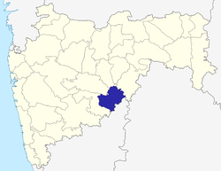 | |
| Cities and towns | ||
| Buildings and landmarks | ||
| Transport |
| |
| Education | ||
| Lok Sabha constituencies | ||
| Vidhan Sabha constituencies | ||
| Personalities | ||
| Neighborhoods |
| |