Noyes, Minnesota
| Noyes, Minnesota | |
|---|---|
| Unincorporated community | |
 Noyes Customs and Immigration Station | |
 Noyes, Minnesota  Noyes, Minnesota Noyes, Minnesota (the US) | |
| Coordinates: 48°59′51″N 97°12′16″W / 48.99750°N 97.20444°WCoordinates: 48°59′51″N 97°12′16″W / 48.99750°N 97.20444°W | |
| Country | United States |
| State | Minnesota |
| County | Kittson County |
| Township | St. Vincent Township |
| Elevation | 787 ft (240 m) |
| Time zone | UTC-6 (Central (CST)) |
| • Summer (DST) | UTC-5 (CDT) |
| Area code(s) | 218 |
| GNIS feature ID | 648769[1] |
Noyes is an unincorporated community in St. Vincent Township, Kittson County, Minnesota, United States. Located in the extreme northwestern corner of the state on the Canada–United States border, it was an important border-crossing location going back to the days of ox roads and later was one of the busiest ports of entry west of the Great Lakes for rail and road traffic.[2] The town of Emerson, Manitoba is directly north of Noyes on the Canadian side of the border.
Noyes is the northern terminus of U.S. Highway 75 and the site where the Burlington Northern-Santa Fe and Soo Line Railroads enter Canada. Since the construction of Interstate 29 on the North Dakota side of the nearby Red River, U.S. Highway 75 has declined in importance. The Canadian government closed Emerson port of entry opposite Noyes in 2003, while the Port of Noyes closed in 2006,[3] leaving the U.S. 75 from the south the only access to Noyes. Travelers must now use the border crossing located less than two miles to the west, but a seven-mile trek from Noyes, through Pembina, North Dakota to Interstate 29. The rail border crossing remains open, but is now managed by the Port of Pembina.
A post office called Noyes was established in 1927, and remained in operation until 1990.[4] The community was named for J. A. Noyes, a customs agent.[5]
Today, Noyes is essentially a quiet community. Because of its proximity to the flood-prone Red River, it is protected by a levee which extends south from Emerson. The levee was built in 1989 as part of an International Levee agreement between both countries.[6] When flooding cuts off Noyes from the rest of the United States, a local state of emergency is declared, allowing residents and emergency personnel to move freely across the border within the levee.[7]
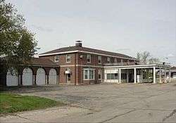
The 1931 Colonial Revival Noyes Customs and Immigration Station is listed on the National Register of Historic Places as a well-preserved example of the nation's first purpose-built border checkpoints at land crossings.[8]
See also
References
- ↑ "Noyes, Minnesota". Geographic Names Information System. United States Geological Survey.
- ↑ "Noyes Port-of-Entry Closes". 56755.blogspot.ca.
- ↑ "Closing of the Port of Noyes, Minnesota, and Extension of the Limits of the Port of Pembina, North Dakota". federalregister.gov. 8 June 2006.
- ↑ "Kittson County". Jim Forte Postal History. Retrieved 17 July 2015.
- ↑ Upham, Warren (1920). Minnesota Geographic Names: Their Origin and Historic Significance. Minnesota Historical Society. p. 279.
- ↑ "Exchange of Notes between the Government of Canada and the Government of the United States of America constituting an Agreement concerning the Construction of a Joint Ring Levee" (PDF). nacse.org.
- ↑ "As Red River crests, a tiny slice of border will dissolve" – via The Globe and Mail.
- ↑ Paul, Daniel D.; Richard Starzak (July 2011). "National Register of Historic Places Registration Form: U.S. Inspection Station—Noyes, Minnesota" (PDF). National Park Service. Retrieved 2016-07-16.
External links
Municipalities and communities of Kittson County, Minnesota, United States | ||
|---|---|---|
| Cities | 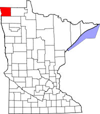 | |
| Townships | ||
| Unorganized territories | ||
| Unincorporated communities | ||
| Ghost town | ||