Pembina–Emerson Border Crossing
| Pembina–Emerson Border Crossing | |
|---|---|
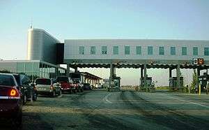 Canada Border Inspection Station at Emerson, MB | |
| Location | |
| Country | United States; Canada |
| Location |
US Port: 10980 Interstate 29, Pembina, North Dakota 58271 Canadian Port: Manitoba Highway 75, Emerson, Manitoba R0A 0L0 |
| Coordinates | 49°00′02″N 97°14′15″W / 49.000477°N 97.237634°W |
| Details | |
| Opened | 1871 |
| US Phone | (701) 825-5800 |
| Canadian Phone | (204) 373-2524 |
| Hours | Open 24 Hours |
|
Website www | |
The Pembina–Emerson Border Crossing connects the city of Pembina, North Dakota and community of Emerson, Manitoba. It is connected by Interstate 29 and U.S. Route 81 on the American side, and by Manitoba Highway 75 on the Canadian side. Over one million travelers are processed at this border crossing each year, making it the second busiest along the Canada–United States border west of the Great Lakes, behind only the Pacific Highway Border Crossing.[1][2] Its location along an international trade corridor makes this an important commercial port. Cross-border trade is valued at approximately CA$20 billion each year.[3]
History
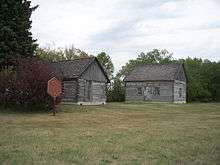
In 1871, Emerson was established as the first land border Customs station in Canada. It was created to protect and ultimately collect duty for trade with the Hudson's Bay Company trading post that was attacked in a Fenian Raid, and subsequently liberated by the U.S. Cavalry earlier that year.[4] The original customs building in Emerson still stands today.
For many years, there were two roads entering Canada at Emerson. The popular Jefferson Highway (U.S. Route 75) entered at Noyes, Minnesota and U.S. Route 81 (U.S. 81) entered from Pembina, North Dakota. All Canada-bound traffic was directed to the brick Customs building in downtown Emerson, which has since been converted into the Emerson Health Centre. Then in the mid-1950s, Canada built separate inspection stations at the border on both roads. The crossing across from Pembina was called "West Lynne" (named after the small village that had been absorbed by the Town of Emerson in 1883) and the larger crossing across from Noyes was known as "Emerson East".
The modern Pembina-West Lynne border crossing opened in 1957 with the completion of I-29. The facilities on the former U.S. Route 81 a short distance to the east were closed and subsequently demolished a few years later. Following the reconfiguration of PTH 75 and PTH 29, most U.S.-bound traffic was diverted to the Pembina crossing. The Canadian and American governments closed the Emerson East and Noyes border stations in 2003 and 2006, respectively, and merged rail inspection operations with the ports at West Lynne and Pembina. The West Lynne border station was renamed Emerson following the closure of Emerson East in 2003.
Both countries are currently in the process of extensively upgrading their facilities and road infrastructure at the Pembina-Emerson Crossing, a project that started in 2017 and will take several years to complete. The U.S. border station was previously upgraded in 1996; the Canada border station in 1999.[1]
Also located near this crossing is Fort Dufferin, a former Canadian police post, immigration station, and base of the North American Boundary Commission, which surveyed and marked the international border as defined in the Treaty of 1818.[5]
Illegal immigration
The number of persons crossing the border illegally into Canada in the Emerson-Pembina area has spiked in recent years, especially following President Donald Trump's Protecting the Nation from Foreign Terrorist Entry into the United States executive order in January 2017. The majority of recent border jumpers are immigrants from Somalia, Ghana, and other African nations seeking asylum in Canada to avoid potential deportation from the U.S. Although persons claiming refugee status are not permitted to migrate to Canada from the U.S. (or vice versa) under the two countries' Safe Third Country Agreement, a well known loophole allows asylum seekers who cross the border illegally and then report to the local police to stay in Canada while their application to live in Canada is processed. This practice is not without danger, especially during the cold prairie winter. On December 24, 2016, two Ghanaian men successfully made it across the border by walking several miles along the Red River in sub-zero temperatures; however both suffered severe frostbite that required amputation of their fingers. This garnered international media attention and led many groups to ask the Canadian government to suspend the Safe Country Agreement in light of the current political climate in the U.S.[6]
See also
References
- 1 2 "Border Infrastructure Investment Plan December 2014" (PDF). US Department of Homeland Security. Retrieved 2 March 2017.
- ↑ "Border Crossing/Entry Data: Query Detailed Statistics". US Department of Transportation, Bureau of Transportation Statistics. Retrieved 19 January 2016.
- ↑ Manitoba Government - Current Transportation Planning Studies
- ↑ McClelland, James; Lewis, Dan (1975). Emerson 1875-1975 A Centennial History (PDF). Town of Emerson, Manitoba. p. 10. Retrieved 19 January 2016.
- ↑ "When Mounties had to go..." Winnipeg Free Press. 7 December 2008. Retrieved 28 August 2012.
- ↑ "New numbers show spike in asylum seekers crossing from U.S. to Manitoba". cbc.ca. 9 January 2017.