Tumalo Mountain
| Tumalo Mountain | |
|---|---|
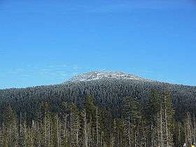 Tumalo Mountain seen from below Mount Bachelor | |
| Highest point | |
| Elevation | 7,779 ft (2,371 m) NAVD 88[1] |
| Prominence | 1,055 ft (322 m) [2] |
| Coordinates | 44°00′19″N 121°38′34″W / 44.005365375°N 121.642663669°WCoordinates: 44°00′19″N 121°38′34″W / 44.005365375°N 121.642663669°W [1] |
| Geography | |
| Location | Deschutes County, Oregon, U.S. |
| Parent range | Cascade Range |
| Topo map | USGS Broken Top |
| Geology | |
| Mountain type | Shield volcano |
| Volcanic arc | Cascade Volcanic Arc |
| Climbing | |
| Easiest route | Trail hide[3] |
Tumalo Mountain is a shield volcano in the Cascade Range of central Oregon, located just northeast of Mount Bachelor across the Cascade Lakes Scenic Byway. Ice Age glaciers carved a large cirque into the northeast flank of the mountain, producing a bowl which is popular with local backcountry skiers. A United States Forest Service fire lookout tower was built on the summit in the 1930s, but abandoned in the 1970s and subsequently removed. A trail to the summit ascends the southwest flank of the volcano.
References
- 1 2 "Tumalo Mt". NGS data sheet. U.S. National Geodetic Survey. Retrieved 2008-11-18.
- ↑ "Tumalo Mountain". Peakbagger.com. Retrieved 2014-12-30.
- ↑ "Tumalo Mountain Trail". SummitPost.org. Retrieved 2016-04-26.
- Harris, Stephen L. (2005). Fire Mountains of the West: The Cascade and Mono Lake Volcanoes (3rd ed.). Mountain Press Publishing Company. ISBN 0-87842-511-X.
- Wood, Charles A.; Jürgen Kienle, eds. (1990). Volcanoes of North America. Cambridge University Press. ISBN 0-521-43811-X.
- Kresek, Ray (1998). Fire Lookouts of the Northwest (3rd ed.). Historic Lookout Project. ISBN 0-87770-632-8.
- "Tumalo Mountain". Geographic Names Information System. United States Geological Survey. Retrieved 2008-11-18.
External links
- "Tumalo Mountain". SummitPost.org.
- Ridler, Keith (2003-12-30). "Tumalo Mountain a wintertime treat". The Bulletin. Bend, Oregon. Retrieved 2007-02-26.
This article is issued from
Wikipedia.
The text is licensed under Creative Commons - Attribution - Sharealike.
Additional terms may apply for the media files.