Rocky Butte
| Rocky Butte | |
|---|---|
 Rocky Butte from I-205. | |
| Highest point | |
| Elevation | 613 ft (187 m) NAVD 88[1] |
| Coordinates | 45°32′48″N 122°33′57″W / 45.546713961°N 122.565940936°WCoordinates: 45°32′48″N 122°33′57″W / 45.546713961°N 122.565940936°W [1] |
| Geography | |
| Location | Multnomah County, Oregon, U.S. |
| Parent range | Boring Lava Field |
| Topo map | USGS Mount Tabor |
|
Rocky Butte Scenic Drive Historic District | |
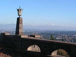 Mount Hood from Rocky Butte | |
  | |
| Location | Rocky Butte Rd. and parts of NE Fremont St. and 92nd Ave., Portland, Oregon |
| Area | 21.5 acres (8.7 ha) |
| Built | 1933[2] |
| Built by | Multnomah Co. Road Dept. |
| NRHP reference # | 91001550[3] |
| Added to NRHP | October 17, 1991[2] |
Rocky Butte is an extinct volcanic cinder cone butte in Portland, Oregon, United States. It is one of four, along with Kelly Butte, Powell Butte, and Mount Tabor, inside the city that are each home to a city park, Rocky Butte playing host to Joseph Wood Hill Park. A rotating beacon at the summit of the butte is visible at night for miles. It is also part of the Boring Lava Field, a group of over 30 cinder cones in Oregon and Washington. The slopes of Rocky Butte are also home of the Rocky Butte Natural Area. In addition, it was formerly home to Rocky Butte Jail and Judson Baptist College. Currently it is the location of a City Bible Church campus, Portland Bible College and City Christian Schools. It lies next to Interstate 205.
Formerly known as Wiberg Butte, a large quantity of rock was removed from the quarry on the east face of Rocky Butte in the 1940s for use in a new Multnomah County jail. After the jail was demolished in the 1980s, much of the stone was reused along the Historic Columbia River Highway. In the early 1900s, the Union Pacific Railroad had a spur into the east side of the Butte at a station named Quarry.[4]
Geography
Rocky Butte lies in the northeast part of Portland,[5] in Multnomah County, which is part of the U. S. state of Oregon. The butte lies within the Portland city limits.[6]
According to the U.S. National Geodetic Survey, Rocky Butte has an elevation of 613 feet (187 m).[1] The Butte is surrounded on almost all sides by the Portland Delta.[5]
Geology
Many volcanic features in the Portland Basin area were destroyed by the Missoula Floods (also known as the Bretz or Ice Age Floods),[7] which took place between 21,000 and 15,000 years ago and probably destroyed small cinder cones (including those made from tuff) and maar craters, burying them under up to 98 feet (30 m) of silt from slack water.[8] Volcanic vents with either extensive eruptions of lava flows or volcanic plugs that filled their vents survived, including Rocky Butte, Prune Hill, and Beacon Rock.[9]
Rocky Butte is a prominent, but isolated hill. It is the core remnant of intrusive rock from a heavily eroded, late Pleistocene volcano that erupted basaltic andesite.[6] Like many other vents in the Boring Lava Field, Rocky Butte consists of basaltic andesite with olivine phenocrysts, and it has a calc-alkalic composition. This basaltic andesite can be observed in exposures that extend from its summit park area to the roads below, as well as in a sill (a sheet of intrusive rock wedged between older layers of sedimentary rock, beds of volcanic lava, or tuff, or along the direction of layering in metamorphic rock) between layers of fluvial gravel from the Troutdale Formation on the Butte's eastern slope, within a flow scarp.[10]
The hill descends to meet the floodplain of the Columbia River, and at lower elevations, the mountain has cliffs on its northern and eastern sides.[5] At the foot of Rocky Butte, there is a fosse (a ditch), which extends for 1 mile (1.6 km) before it opens toward the Columbia River to the north and divides to the south into two arms that run west and southwest. This depression has a width of less than 0.5 miles (0.80 km) and an average depth between 20 to 25 feet (6.1 to 7.6 m).[11] There is another terrace, with a height of 250 feet (76 m), which sits next to Rocky Butte. It runs for 9 miles (14 km) to the west, with a descent of 150 feet (46 m) over that distance.[11] To the south, this terrace also has a long depression near its base, which extends for 1.5 miles (2.4 km) from Rocky Butte.[12] These features are likely the product of more than just erosional forces; Bretz (1925) argued that the fosse resulted from fluid eddies that pushed downard where currents interacted with the eastern side of Rocky Butte, and the terrace formed from accumulation of deposits in water under the blockage.[13]
Eruptive history
Evarts et al. (2009) assign Rocky Butte an age younger than 500,000 years.[14] One Argon–argon dating experiment determined an age for Rocky Butte lava of 285,000 years ± 16,000 years ago, which matches the normal magnetic polarity for the lava deposits at the Butte.[10]
Human history
During the 1930s, employees of the Works Progress Administration constructed a park at the summit, at an elevation of about 600 feet (180 m). Rock from Rocky Butte's eastern slopes was used for the Multnomah County jail building, which was later demolished during the 1980s as the Interstate 205 route was being built. Some of these rocks were used for renovation of the Historic Columbia River Highway.[6]
There is a communications tower on the southern end of the volcano.[10]
Recreation
The park at the summit of Rocky Butte offers views of the Boring Lava Field, Mount St. Helens, and Mount Hood.[6] It lies in the throat of Rocky Butte's former volcanic vent.[6]
Rocky Butte is a popular location for rock climbers in the Portland area. It hosts approximately 150 routes which vary in difficulty and type. The majority of routes will be top-roped, though there are some options for traditional climbing and lead climbing. The most popular climbs are on the section known as Video Bluff.
Rocky Butte does not have an official hiking trail. An unmarked primitive trail begins just east of The Grotto near the intersection of Skidmore Street and 92nd Avenue. The path ascends the butte mostly on the I-205 (east) side, through several vagrant campsites. The path goes under Rocky Butte Road near the Portland Bible Temple domes of the City Bible Church. From this point, a hiker can follow the paved road to the summit or search for the upper path. The upper path begins above the Portland Bible College campus, near an above-ground cistern surrounded by a chain-link fence. The upper path is even more primitive than the lower, to the point of essentially bushwhacking through blackberry vines all the way to the steps on the north slope of the summit. An alternative and more distinct upper trail connects the high side of the tunnel on Rocky Butte Road to the west slope of the summit. An apparent trail beginning at the end of Sacramento Street, east of 93rd Avenue, peters out after about 1 kilometre (0.62 mi).
The summit of Rocky Butte is a Portland city park, Joseph Wood Hill Park. The summit is also noted on maps as Rocky Butte Natural Area, even though it is well developed. An Oregon state park, Rocky Butte State Park, lies mostly on the forested south and west slopes of the butte but does not have any official trails.
Rotating beacon
The revolving beacon is located at the summit, inside the parapet wall. It is a rotating medium intensity white light which flashes intermittently. The tower also flashed a red beacon until it was either turned off or removed in the late 1970s. The beacon was erected in 1933 by the U.S. Bureau of Lighthouses for aircraft navigation and was considered outdated by the mid 1960s.
See also
References
- 1 2 3 "Rocky Butte Reset". NGS data sheet. U.S. National Geodetic Survey. Retrieved October 12, 2018.
- 1 2 "Oregon National Register List" (PDF). Oregon Parks and Recreation Department. June 6, 2011. p. 39. Retrieved September 27, 2013.
- ↑ National Park Service (2010-07-09). "National Register Information System". National Register of Historic Places. National Park Service.
- ↑ McArthur, Lewis A.; Lewis L. McArthur (2003) [1928]. Oregon Geographic Names (Seventh ed.). Portland, Oregon: Oregon Historical Society Press. ISBN 0-87595-277-1.
- 1 2 3 Bretz 1925, p. 254.
- 1 2 3 4 5 Evarts et al. 2009, p. 263.
- ↑ Madin 2009a, p. 76.
- ↑ "The Boring Volcanic Field — Hills of the Portland Basin". Cascades Volcano Observatory. United States Geological Survey. November 13, 2017. Retrieved September 26, 2018.
- ↑ Evarts et al. 2009, p. 257.
- 1 2 3 Evarts et al. 2009, p. 264.
- 1 2 Bretz 1925, p. 255.
- ↑ Bretz 1925, pp. 255–256.
- ↑ Bretz 1925, p. 256.
- ↑ Evarts et al. 2009, p. 256.
Sources
- Bretz, J. H. (1925). "The Spokane Flood beyond the Channeled Scablands". The Journal of Geology. University of Chicago Press. 33 (3): 236–259. doi:10.1086/623179.
- Evarts, R. C.; Conrey, R. M.; Fleck, R. J.; Hagstrum, J. T. (January 2009), O'Connor, J. E.; Dorsey, R. J.; Madin, I. P., eds., "The Boring Volcanic Field of the Portland-Vancouver area, Oregon and Washington: Tectonically anomalous forearc volcanism in an urban setting", Volcanoes to Vineyards: Geologic Field Trips Through the Dynamic Landscape of the Pacific Northwest, Geological Society of America, pp. 253–270, doi:10.1130/2009.fld015(13), ISBN 9780813756158, Geological Society of America Field Guide 15 .
- Madin, I. P. (2009a). "Portland, Oregon, geology by tram, train, and foot" (PDF). The Ore Bin. Oregon Department of Geology and Mineral Industries. 69 (1): 73–92.
External links
| Wikimedia Commons has media related to Rocky Butte. |
- Photos of Rocky Butte on Vintage Portland
- Interviews with Rocky Butte locals
- Rocky Butte Preservation Society
- Rocky Butte Jail history
- Rocky Butte Scenic Drive Historic District at PortlandMaps
- Rocky Butte history at Living New Deal
- NRHP Registration Form, 1991
- "Rocky Butte". Geographic Names Information System. United States Geological Survey. Retrieved 2008-11-17.
- "Rocky Butte, Portland, Oregon". USGS Cascades Volcanic Observatory. Retrieved 2008-04-01.
- "Joseph Wood Hill Park". Portland Parks & Recreation. Retrieved 2008-04-01.
- "Rocky Butte Natural Area". Portland Parks & Recreation. Retrieved 2008-04-01.