Powell Butte
| Powell Butte | |
|---|---|
 | |
| Highest point | |
| Elevation | 614 ft (187 m) NAVD 88[1] |
| Coordinates | 45°29′14″N 122°30′06″W / 45.487348619°N 122.501797539°WCoordinates: 45°29′14″N 122°30′06″W / 45.487348619°N 122.501797539°W [1] |
| Geography | |
 Powell Butte | |
| Location | Multnomah County, Oregon, U.S. |
| Parent range | Cascades |
| Topo map | USGS Gladstone |
| Geology | |
| Mountain type | Cinder cone |
| Volcanic field | Boring Lava Field |
Powell Butte is an extinct volcanic cinder cone butte in Portland, Oregon, United States. It is one of four such cones (the others being Rocky Butte, Kelly Butte and Mount Tabor) inside the city that are home to a city park and is part of the Boring Lava Field, an area of extinct volcanoes. Powell Butte hosts the Powell Butte Nature Park.[2]
Within the butte, two underground reservoirs each hold 50 million gallons of fresh water as a primary part of the public water system for Portland and much of the surrounding region.[3]
Recreational use
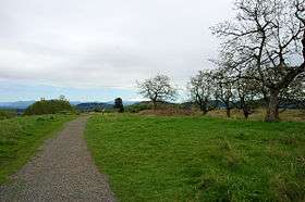
The Powell Butte Nature Park visitor center, parking lots and main trailheads are located on 162nd Avenue, just south of SE Powell Blvd. The 614-foot (187 m) summit has over 9 miles (14 km) of trails. The Mountain View Trail is paved to the summit. Most of the other trails are gravel or dirt. Pets on-leash, horses and mountain bicycles are allowed on the trails. The visitor center has water fountains and flush toilets. Other trailheads are at the eastern terminus of Holgate Blvd.; near the intersections of 148th Ave. and Center St., 141st Ave. and Raymond St., and 145th Ave. and Ellis St.; and along the Springwater Corridor about three blocks east of 145th Ave.
References
- 1 2 "Powell Butte". NGS data sheet. U.S. National Geodetic Survey. Retrieved 2008-04-02.
- ↑ "Powell Butte Nature Park". Portland Parks & Recreation. Retrieved 2008-11-17.
- ↑ "Powell Butte Reservoir & Nature Park". Portland Water Bureau. Retrieved 2018-07-20.
External links
- "Powell Butte". Geographic Names Information System. United States Geological Survey. Retrieved 2008-11-17.
- "Powell Butte Cinder Cone, Portland, Oregon". USGS Cascades Volcanic Observatory. Retrieved 2008-04-01.
- "Friends of Powell Butte Nature Park". Retrieved 2008-04-01.
- Aerial photo of Powell Butte from USGS