Troy Hill (Pittsburgh)
| Troy Hill | |
|---|---|
| Neighborhood of Pittsburgh | |
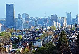 View of Troy Hill from North East April 2014 | |
 | |
| Coordinates: 40°28′N 79°59′W / 40.47°N 79.98°W | |
| Country | United States |
| State | Pennsylvania |
| County | Allegheny County |
| City | Pittsburgh |
| Area[1] | |
| • Total | 0.46 sq mi (1.2 km2) |
| Population (2010)[1] | |
| • Total | 2,714 |
| • Density | 5,900/sq mi (2,300/km2) |
| ZIP Code | 15212 |
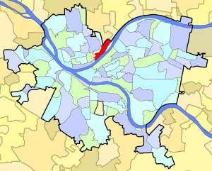
Troy Hill is a neighborhood in Pittsburgh, Pennsylvania's North Side. It has a zip code of 15212, and has representation on Pittsburgh City Council by the council member for District 1 (North Neighborhoods).
Troy Hill sits on a plateau above the Allegheny River on the North Side of Pittsburgh. It is approximately 3 kilometers (1.9 mi) long from Vinial Street to the end of Lowrie Street and only 1 kilometer (0.62 mi) wide from Wicklines Lane to Herr's Island.
History
Troy Hill was part of The Reserve Tract incorporated in 1833. Originally called the village of New Troy, it was settled by German immigrants who worked in the mills, tanneries, breweries and railroads that lined the Allegheny river. The migration up to Troy Hill began when a Catholic church opened a small cemetery in 1842. By 1866 one hundred families were officially Troy Hill residents. In 1877, Troy Hill became the thirteenth ward of the City of Allegheny, Pennsylvania. Subsequently, when the City of Allegheny was annexed, Troy Hill became a neighborhood of the city of Pittsburgh.
Troy Hill is home to six historic landmarks: the Troy Hill Firehouse, Saint Anthony's Chapel, the Rectory of Most Holy Name of Jesus, the Troy Hill Incline Building, the Allegheny Reservoir Wall, and the Ober-Guehl house.
In the 1830s, Troy Hill's population escalated significantly, resulting in the need of a school. In 1836, a 1-room brick school house was built in "New Troy" and named Mount Troy School #1, because at the time it was located in Reserve Township. It was sold in 1860, which then was replaced by a new, 2 room brick school house. A decade after the civil war, the pupils increased to around 200, so 2 more rooms were added in 1874. Troy Hill was now part of Allegheny's School System, and in 1883 the school was demolished and a new one was built in its place. That building was then also replaced by the Troy Hill School of 1907, but then was shut down in 1960 and demolished. The site of the original school is now a community park.[2]
Troy Hill was the home to Commissioner Thomas J. Foerster who served 10 years in the state house and 28 years as the Commissioner of Allegheny County. He also served on the first county council established in 2000. Another notable resident was Andrew (Huck) Fenrich who served 9 terms in the state house, was executive secretary for the mayor of Pittsburgh, and also served as executive secretary for the Allegheny County Democrats.
Until 1959 the neighbourhood was served by the 4 Troy Hill trolley operated by Pittsburgh Railways.[3]
| Historical population | ||
|---|---|---|
| Year | Pop. | ±% |
| 1940 | 7,319 | — |
| 1950 | 6,530 | −10.8% |
| 1960 | 5,141 | −21.3% |
| 1970 | 4,205 | −18.2% |
| 1980 | 3,251 | −22.7% |
| 1990 | 2,742 | −15.7% |
| 2000 | 2,540 | −7.4% |
| 2010 | 2,714 | +6.9% |
| Source: PGHSNAP Census Data[4] | ||
Other names
While "Troy Hill" generally refers to the historically German neighborhood atop the Troy Hill plateau, the neighborhood's boundaries also encompass the narrow and flat river plain that sits between the plateau and the Allegheny River. As of 2011, this river plain is dominated by Pennsylvania Route 28, an expressway which begins at East Ohio Street and then follows the river north. But before Route 28 became an expressway, this plain was a Croatian neighborhood that was settled by
immigrants from Jastrebarsko, who called the neighborhood "Mala Jaska" and founded St. Nicholas Parish.[5][6]
Troy Hill in Hollywood Films
Several Hollywood films have scenes filmed in Troy Hill, including Hoffa (1992),[7] Innocent Blood (1992),[7] Striking Distance (1993),[8] and Adventureland (2009).[8]
Surrounding and adjacent neighborhoods
Troy Hill has five borders including the Pittsburgh neighborhoods of Spring Garden to the north and northwest, East Allegheny to the west, and North Shore to the southwest as well as Reserve Township to the north-northwest and the borough of Millvale to the northeast. Troy Hill is also adjacent to the Strip District across the Allegheny River with a direct link via 31st Street Bridge.
Gallery
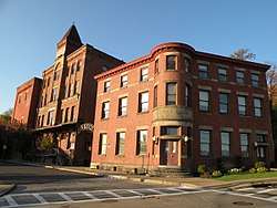 Eberhardt and Ober Brewery (now part of the Penn Brewery complex), founded in 1848, in the Troy Hill neighborhood of Pittsburgh, Pennsylvania. Buildings shown here circa 1880.
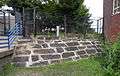 Great Stone Wall, Allegheny Reservoir, located by Cowley Spray Park at the Troy Hill Playground, built 1848, the last remnant of the former Allegheny City Reservoir.
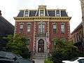 Most Holy Name of Jesus Rectory, built around 1875, at 1700 Harpster Street.
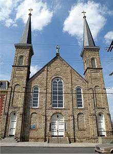 Saint Anthony's Chapel, built in 1880, at 1700 Harpster Street. About five thousand relics are housed in the chapel, making it the largest collection of relics outside the Vatican.[9][10]
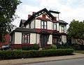 Ober-Guehl House, built around 1877, at 1501 Lowrie Street.
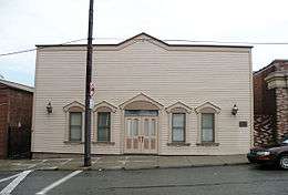 Former Troy Hill Incline Station, built in 1887, at 1733 Lowrie Street.
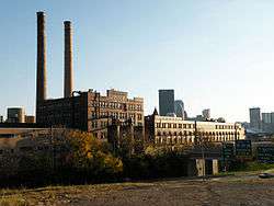 H. J. Heinz Company, in the Troy Hill neighborhood of Pittsburgh, PA, since 1890.
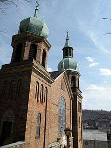 Saint Nicholas Croatian Catholic Church, built from 1900 to 1904, at 1326 East Ohio Street. The church was established in 1894, and is the site of the first Croatian Catholic Parish in America. It was demolished in 2013 to make room for the expansion of Route 28
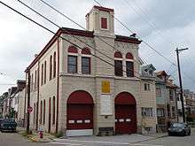 Troy Hill Fire Station#39, built in 1901, at the corner of Ley and Froman Streets. As of 2013, no longer a firehall, but used by the City as home of the Police Bureau's Commercial Vehicle Enforcement division.
 Heinz Lofts, built from 1913 to 1927, at 300 Heinz Street.
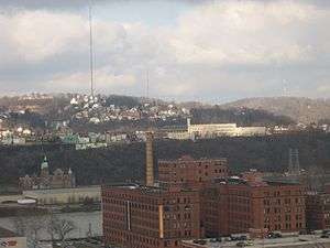 A view of Troy Hill (center) with Spring Hill in the background and The Cork Factory lofts in the Strip District in the foreground.
See also
References
- 1 2 "PGHSNAP 2010 Raw Census Data by Neighborhood". PGHSNAP Utility. Pittsburgh Department of City Planning. 2012. Retrieved 28 June 2013.
- ↑ Pfeil, Richard J., Jean E. Koch, Janet M. Koch, and Robert J. Bartolowits. Footprints of Troy Hill. N.p.: n.p., 2012. Print.
- ↑ "Pittsburghtransit.com - The Routes - PCC Operation". August 28, 2005. Archived from the original on August 28, 2005. Retrieved August 9, 2009.
- ↑ "PGH Snap Data".
- ↑ Nelson Jones, Diana (May 20, 2009). "North Side's "Mala Jaska" deteriorates as Route 28 grows". Pittsburgh Post-Gazette. Retrieved 3 November 2011.
- ↑ "North Side: East North Side". Bridging the Urban Landscape. Carnegie Library of Pittsburgh. Retrieved 3 November 2011.
- 1 2 Hinds, Michael Decourcy (1992-02-07). "Pittsburgh Journal; Horror Is a Thing Of Beauty In a Movie". The New York Times. ISSN 0362-4331. Retrieved 2017-03-18.
- 1 2 Cato, Jason. "Where the 'Action!' is: Film crews invade city neighborhoods". TribLIVE.com. Retrieved 2017-03-18.
- ↑ "Anthony's Chapel in Most Holy Name of Jesus Parish". Saints Alive. The International Crusade for Holy Relics. 1998-09-05. Retrieved 2006-09-22.
- ↑ Meinzer, Melissa (2007-01-18). "St. Anthony's Chapel". Pittsburgh City Paper. Retrieved 2007-02-27.
External links
| Wikimedia Commons has media related to Troy Hill. |