Munsonville, New Hampshire
| Munsonville, New Hampshire | |
|---|---|
| Unincorporated community | |
 Munsonville sign | |
 Munsonville  Munsonville | |
| Coordinates: 43°0′51″N 72°08′55″W / 43.01417°N 72.14861°WCoordinates: 43°0′51″N 72°08′55″W / 43.01417°N 72.14861°W | |
| Country | United States |
| State | New Hampshire |
| County | Cheshire |
| Town | Nelson |
| Elevation | 1,260 ft (380 m) |
| Time zone | UTC-5 (Eastern (EST)) |
| • Summer (DST) | UTC-4 (EDT) |
| ZIP code | 03457 |
| Area code(s) | 603 |
| GNIS feature ID | 868664[1] |
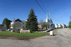
Munsonville is an unincorporated community in the town of Nelson in Cheshire County, New Hampshire. It is located in the northwestern corner of Nelson, around the outlet of Granite Lake.
New Hampshire Route 9, a major east-west highway in the state connecting Concord and Keene, bypasses Munsonville to the south. (The highway ran through the center of the village until the 1990s.)
"Munsonville" and "Nelson" are both valid place names used for the 03457 ZIP code.
References
Municipalities and communities of Cheshire County, New Hampshire, United States | ||
|---|---|---|
| City | 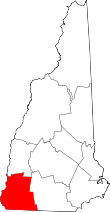 | |
| Towns | ||
| CDPs | ||
| Other villages | ||
This article is issued from
Wikipedia.
The text is licensed under Creative Commons - Attribution - Sharealike.
Additional terms may apply for the media files.