Trowbridge, Cardiff
| Trowbridge | |
|---|---|
| Community/Electoral ward | |
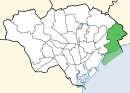 Location of Trowbridge ward within Cardiff | |
| Population | 16,194 (2011)[1] |
| OS grid reference | ST230800 |
| Principal area | |
| Country | Wales |
| Sovereign state | United Kingdom |
| Post town | CARDIFF |
| Postcode district | CF3 |
| Dialling code | +44-29 |
| Police | South Wales |
| Fire | South Wales |
| Ambulance | Welsh |
| EU Parliament | Wales |
| UK Parliament | |
| Welsh Assembly | |
| Councillors | 4 |
Trowbridge is a district, community and coterminous electoral ward on the eastern edge of the city of Cardiff, capital of Wales.
The community and electoral ward includes some or all of the areas of the St Mellons estate and Trowbridge, as well as part of the Wentlooge Levels between the mainline railway and the coast.[2] It is bounded by the village of Old St Mellons to the north; Marshfield (in Newport principal area) to the east; and Splott and Rumney to the west.
History
Trowbridge largely dates from the second half of the 20th century, when housing spread east from Rumney onto the farmland of the area.[3]
Until 1938, the area was part of the civil parish of Rumney, in the historic county of Monmouthshire.
Governance
Trowbridge is in the parliamentary constituency of Cardiff South & Penarth and the Welsh Assembly constituency of the same name.
The Trowbridge electoral ward is represented by four councillors on Cardiff Council. At the Cardiff Council election on 4 May 2017 the ward elected three Labour Party councillors and one Liberal Democrat.[4] Prior to this Trowbridge elected Labour councillors, with the exception of 2004 when a Liberal Democrat won a seat.[5]
Schools
Trowbridge Primary School. St John Lloyd primary school.
References
- ↑ "Ward population 2011". Retrieved 9 April 2015.
- ↑ "Election Maps". Ordnance Survey. Retrieved 14 January 2017.
- ↑ "The History of Cardiff's Suburbs - Trowbridge". Cardiffians.co.uk. Retrieved 20 April 2018.
- ↑ "Election results for Trowbridge - Cardiff Council Elections 2017 - Thursday, 4th May, 2017". Cardiff Council. Retrieved 14 January 2018.
- ↑ "Cardiff Council Election Results 1995-2012" (PDF). The Elections Centre. Retrieved 14 January 2018.
| About Cardiff | 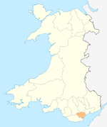 | |
|---|---|---|
| Cardiff templates |
| |
| Neighbourhoods |
| |
Principal areas of Wales | ||
Coordinates: 51°30′49″N 3°06′40″W / 51.51366°N 3.11101°W