Gabalfa
Gabalfa
| |
|---|---|
 St Marks church, Gabalfa | |
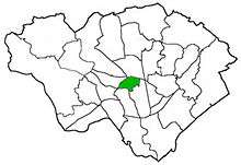
 Gabalfa Gabalfa shown within Cardiff | |
| Population | 8,790 (2011)[1] |
| Principal area | |
| Ceremonial county | |
| Country | Wales |
| Sovereign state | United Kingdom |
| Post town | CARDIFF |
| Postcode district | CF14 |
| Dialling code | +44-29 |
| Police | South Wales |
| Fire | South Wales |
| Ambulance | Welsh |
| EU Parliament | Wales |
| UK Parliament | |
| Welsh Assembly | |
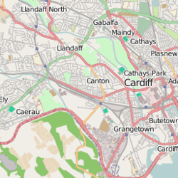
Gabalfa (English: /ɡəˈbælvə/, Welsh pronunciation: [ɡaˈbalva]) is a district and community in the north of the city of Cardiff, capital of Wales. It is characterised by a four-lane fly over road at the Gabalfa Interchange, where the A48 road meets the A470 road (North Road) which leads from Cardiff to northern Wales, and the A469 road (Caerphilly Road). The area is also the site of the All Nations Centre.
The name is derived from the Welsh 'Ceubalfa', which is literally translated as 'place of the boat'. It was formerly the site of a ferry crossing across the River Taff, upon which a school is now built.[2]
The area around St. Joseph's Church near to Companies' House is known as 'the Colonies' due to the number of street names after former British colonies, such as Australia Road, Newfoundland Road and many more.
Politics
The electoral ward of Gabalfa lies within the parliamentary constituency of Cardiff North, which has been represented since 2017 by Welsh Labour MP Anna McMorrin. In the Welsh Assembly, Cardiff North is represented by Welsh Labour AM Julie Morgan.
Gabalfa was served by two councillors: Ed Bridges (Liberal Democrat), elected in 2004, and Gareth Holden, elected in 2012. Holden was elected as a Liberal Democrat but resigned from the party in 2013.[3] He lost out to a Liberal Democrat candidate in the May 2017 election.
It is bounded by Birchgrove and Heath to the north, Cathays and Maindy to the south, and Llandaff North to the northwest.
Transport
The area is known for the Gabalfa Interchange (also known as the Gabalfa flyover) where the A48 Eastern Avenue, A470 North Road, and the A469 Whitchurch Road (south)/Caerphilly Road (north) meet.
Cardiff Bus' service 35 bus circles the area before heading to Cardiff Bay via Cathays and Central station. Services 1/2 Bay Circle run along Western Avenue towards Heath or Llandaff. Additionally, the following services stop at the Gabalfa Interchange:
- 8 (University Hospital of Wales) or (Cathays-Roath-Central Station-Grangetown-Cardiff Bay)
- 21 (Rhiwbina-Coryton-Whitchurch) or (Central Stn)
- 23 (Whitchurch-Coryton-Rhiwbina) or (Central Stn)
- 24 (Whitchurch-Llandaff North-Pontcanna-Llandaff)
- 25 (Central Stn)
- 27 Capital City Green (Heath-Birchgrove-Thornhill) or (Central Stn)
- 35 (Gabalfa) or (Cathays-Central Stn-Cardiff Bay)
There are currently no railway stations located within Gabalfa, although a new railway station serving the ward has been proposed as part of the county council's local transport plan.[4] The nearest railway stations are Heath Low Level and Heath High Level to the north of the ward, and Cathays to the south. Llandaf railway station is in reasonable distance of western parts of Gabalfa, with services northbound to either Treherbert, Merthyr Tydfil or Aberdare via Pontypridd or southbound to Cardiff Central via Queen Street.
Gallery
 Africa Gardens
 Part of the Gabalfa Interchange and flyover
References
- ↑ "Ward population 2011". Retrieved 8 April 2015.
- ↑ "BBC - South East Wales Streets of Cardiff - Gabalfa". Retrieved 2008-01-16.
- ↑ Peter Law (21 January 2013). "Lib Dem councillor leaves party in anger at coalition government". Wales Online. Retrieved 2018-04-20.
- ↑ "Cardiff County Council - Local Transport Plan 2000-2016". Cardiff County Council. 2000-08-01. Archived from the original (PDF) on 2007-09-26. Retrieved 2008-01-17.
External links
| About Cardiff | 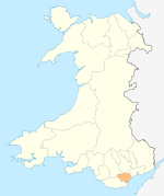 | |
|---|---|---|
| Cardiff templates |
| |
| Neighbourhoods |
| |
Principal areas of Wales | ||