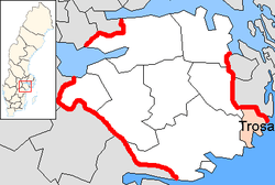
Trosa Municipality
| Trosa Municipality Trosa kommun | ||
|---|---|---|
| Municipality | ||
| ||
 | ||
| Country | Sweden | |
| County | Södermanland County | |
| Seat | Trosa | |
| Area[1] | ||
| • Total | 664.76 km2 (256.67 sq mi) | |
| • Land | 209.73 km2 (80.98 sq mi) | |
| • Water | 455.03 km2 (175.69 sq mi) | |
| Area as of 1 January 2014. | ||
| Population (31 December 2017)[2] | ||
| • Total | 12,916 | |
| • Density | 19/km2 (50/sq mi) | |
| Time zone | UTC+1 (CET) | |
| • Summer (DST) | UTC+2 (CEST) | |
| ISO 3166 code | SE | |
| Province | Södermanland | |
| Municipal code | 0488 | |
| Website |
www | |

Trosa Municipality (Trosa kommun) is a municipality in Södermanland County in southeast Sweden. The municipality is built up by the localities of Vagnhärad, Västerljung, Stensund, Sund and the town of Trosa. The seat of the municipality is located in the town of Trosa.
The present municipality was created as recently as 1992, when Nyköping Municipality, which Trosa had been a part of since 1974, was split in three parts.
The municipality borders to Nyköping Municipality, Gnesta Municipality, and in the north to Södertälje Municipality in Stockholm County.
Events
Trosa is known for its season markets, Trosa Market in the summer and the Harvest and Christmas markets during fall and winter. There is also the annual race of Trosa Stadslopp, when over 1000 people run through on the streets of Trosa.
Tourism
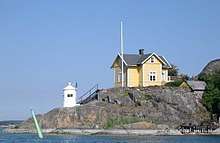
During the summer the municipality's population increases from 10 000 to 45 000. Mostly because the area got a lot of summer cabins, but there is also a significant number of tourists. A lot of boat tourists is also to be seen in the harbor or on the many islands in the municipals archipelago.
Culture
Within the municipality there are four churches; of those the church in Trosa rural parish is from the 13th century; Västerljung's Church is also from the medieval age; and the Trosa church is one of few 18th century churches in the area.
Elections
These are the results of the Riksdag elections for Trosa Municipality since the inaugual election under its current entity in 1991. For the 1991 to 1998 results the exact numbers of the Sweden Democrats were not published by the SCB due to the party's small size nationally.
Riksdag
| Year | Turnout | Votes | V | S | MP | C | L | KD | M | SD | ND |
|---|---|---|---|---|---|---|---|---|---|---|---|
| 1991[3] | 88.4 | 5,873 | 3.1 | 32.5 | 3.5 | 8.4 | 10.7 | 4.8 | 26.8 | 0.0 | 9.6 |
| 1994[4] | 89.1 | 6,225 | 4.6 | 41.8 | 5.8 | 6.7 | 8.6 | 3.4 | 26.3 | 0.0 | 0.8 |
| 1998[5] | 83.8 | 5,977 | 8.8 | 34.7 | 5.8 | 4.1 | 4.6 | 14.3 | 26.4 | 0.0 | 0.0 |
| 2002[6] | 83.1 | 6,218 | 5.5 | 40.9 | 5.3 | 5.1 | 13.3 | 9.3 | 19.0 | 0.6 | 0.0 |
| 2006[7] | 85.5 | 6,739 | 3.4 | 31.0 | 4.9 | 6.3 | 7.9 | 7.0 | 35.2 | 1.9 | 0.0 |
| 2010[8] | 87.9 | 7,487 | 3.5 | 23.5 | 7.4 | 5.2 | 7.0 | 5.4 | 41.3 | 5.8 | 0.0 |
| 2014[9] | 89.4 | 7,983 | 3.5 | 26.6 | 6.6 | 6.4 | 5.1 | 4.3 | 32.3 | 12.2 | 0.0 |
Blocs
This lists the relative strength of the socialist and centre-right blocks since 1991, but parties not elected to the Riksdag are inserted as "others", including the Sweden Democrats results from 1988 to 2006, but also the Greens in 1991. The sources are identical to the table above. The coalition or government mandate marked in bold formed the government after the election. New Democracy got elected in 1991 but are still listed as "other" due to the short lifespan of the party.
| Year | Turnout | Votes | Left | Right | SD | Other | Elected |
|---|---|---|---|---|---|---|---|
| 1991 | 88.4 | 5,873 | 35.6 | 50.7 | 0.0 | 13.7 | 95.9 |
| 1994 | 89.1 | 6,225 | 52.2 | 45.0 | 0.0 | 2.8 | 97.2 |
| 1998 | 83.8 | 5,977 | 49.3 | 49.4 | 0.0 | 1.3 | 98.7 |
| 2002 | 83.1 | 6,218 | 51.7 | 46.7 | 0.0 | 1.6 | 98.4 |
| 2006 | 85.5 | 6,739 | 39.3 | 56.4 | 0.0 | 4.3 | 95.7 |
| 2010 | 87.9 | 7,487 | 34.4 | 58.9 | 5.8 | 0.9 | 99.1 |
| 2014 | 89.4 | 7,983 | 36.7 | 48.1 | 12.2 | 3.0 | 97.0 |
References
- ↑ "Statistiska centralbyrån, Kommunarealer den 1 januari 2014" (Microsoft Excel) (in Swedish). Statistics Sweden. Retrieved 2014-04-18.
- ↑ "Folkmängd i riket, län och kommuner 31 december 2017" (in Swedish). Statistics Sweden. February 21, 2018. Retrieved February 21, 2018.
- ↑ "Riksdagsvalet 1991 (page 23)" (PDF) (in Swedish). SCB. Retrieved 26 July 2017.
- ↑ "Riksdagsvalet 1994 (page 37)" (PDF) (in Swedish). SCB. Retrieved 26 July 2017.
- ↑ "Riksdagsvalet 1998 (page 33)" (PDF) (in Swedish). SCB. Retrieved 26 July 2017.
- ↑ "Valresultat Riksdag Trosa kommun 2002" (in Swedish). Valmyndigheten. Retrieved 26 July 2017.
- ↑ "Valresultat Riksdag Trosa kommun 2006" (in Swedish). Valmyndigheten. Retrieved 26 July 2017.
- ↑ "Valresultat Riksdag Trosa kommun 2010" (in Swedish). Valmyndigheten. Retrieved 26 July 2017.
- ↑ "Valresultat Riksdag Trosa kommun 2014" (in Swedish). Valmyndigheten. Retrieved 26 July 2017.
External links
- Trosa Municipality - Official site (in Swedish)
- Article Trosa - From Nordisk familjebok (in Swedish)
- Trosa Flygklubb - The local Trosa aviation club and airport