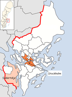
Södertälje Municipality
| Södertälje Municipality Södertälje kommun | ||
|---|---|---|
| Municipality | ||
| ||
 | ||
| Country | Sweden | |
| County | Stockholm County | |
| Seat | Södertälje | |
| Area[1] | ||
| • Total | 694.24 km2 (268.05 sq mi) | |
| • Land | 525.15 km2 (202.76 sq mi) | |
| • Water | 169.09 km2 (65.29 sq mi) | |
| Area as of 1 January 2014. | ||
| Population (31 December 2017)[2] | ||
| • Total | 96,032 | |
| • Density | 140/km2 (360/sq mi) | |
| Time zone | UTC+1 (CET) | |
| • Summer (DST) | UTC+2 (CEST) | |
| ISO 3166 code | SE | |
| Province | Södermanland | |
| Municipal code | 0181 | |
| Website | www.sodertalje.se | |
| Density is calculated using land area only. | ||

Södertälje Municipality (Södertälje kommun) is a municipality in Stockholm County in east central Sweden. Its seat is located in the city of Södertälje.
It borders to Lake Mälaren in the north and the Baltic Sea in the south, and within the Stockholm County to Nykvarn Municipality and Salem Municipality and also border Södermanland County and its municipals Gnesta and Trosa.
Södertälje also has the fifth largest number of Finnish-speaking Sweden Finns in Sweden: 11,000, or around 13 per cent of the city population. Thus, taken together, Finns and Estimated 120,000 Assyrians/Syriacs in Sweden and account for 40 per cent of the inhabitants of the city.
The municipality was created 1967–1971 through the amalgamation of the former City of Södertälje with large rural and suburban areas surrounding it. In 1999, it was split when a new entity, Nykvarn Municipality, was detached from Södertälje Municipality.
Industry
Two big industries dominate Södertälje. Scania AB is a world leading manufacturer of trucks and busses and employed over 9.000 people. AstraZeneca is an international manufacturer of drugs (medicine) employing over 3.000 people. The municipal Södertälje itself employs over 5.600 people including teachers and people working with elderly people.
Södertälje has a canal, Södertälje Canal, that is very important for the ships who want to reach the big lake Mälaren from the Baltic Sea.
Notable people
- Björn Borg, former tennis player
- Johan Edlund, singer and leader of the bands Tiamat and Lucyfire
- Tom Wandell, NHL Player
Localities
- Gnesta (minor part of)
- Hölö
- Järna
- Mölnbo
- Södertälje (seat)
Elections
Riksdag
These are the local results of the Riksdag elections since the 1972 municipality reform. The results of the Sweden Democrats were not published by SCB between 1988 and 1998 at a municipal level to the party's small nationwide size at the time. "Votes" denotes valid votes, whereas "Turnout" denotes also blank and invalid votes.
| Year | Turnout | Votes | V | S | MP | C | L | KD | M | SD | ND |
|---|---|---|---|---|---|---|---|---|---|---|---|
| 1973[3] | 90.2 | 42,332 | 6.5 | 46.0 | 0.0 | 23.2 | 8.1 | 1.5 | 13.9 | 0.0 | 0.0 |
| 1976[4] | 90.9 | 43,826 | 5.5 | 44.4 | 0.0 | 22.2 | 10.4 | 1.0 | 15.9 | 0.0 | 0.0 |
| 1979[5] | 89.5 | 43,789 | 6.6 | 46.5 | 0.0 | 14.8 | 10.1 | 1.2 | 19.9 | 0.0 | 0.0 |
| 1982[6] | 90.4 | 45,372 | 6.5 | 49.2 | 2.3 | 11.5 | 4.8 | 1.3 | 24.0 | 0.0 | 0.0 |
| 1985[7] | 88.8 | 46,230 | 6.3 | 47.1 | 1.9 | 7.1 | 15.6 | 0.0 | 21.0 | 0.0 | 0.0 |
| 1988[8] | 83.0 | 44,563 | 6.8 | 43.7 | 6.5 | 7.7 | 14.0 | 1.8 | 18.3 | 0.0 | 0.0 |
| 1991[9] | 83.9 | 45,204 | 4.3 | 40.3 | 4.1 | 5.3 | 9.6 | 5.0 | 22.9 | 0.0 | 7.9 |
| 1994[10] | 84.6 | 46,151 | 5.5 | 49.2 | 5.9 | 4.5 | 7.1 | 3.1 | 22.8 | 0.0 | 1.1 |
| 1998[11] | 77.2 | 39,428 | 10.3 | 41.4 | 5.4 | 3.4 | 3.9 | 10.3 | 22.5 | 0.0 | 0.0 |
| 2002[12] | 76.1 | 40,914 | 7.5 | 42.2 | 5.9 | 3.3 | 12.9 | 9.6 | 14.4 | 0.7 | 0.0 |
| 2006[13] | 77.5 | 42,920 | 5.6 | 36.0 | 6.4 | 5.4 | 7.2 | 7.2 | 26.8 | 1.9 | 0.0 |
| 2010[14] | 79.5 | 45,458 | 5.2 | 34.0 | 8.3 | 3.9 | 6.2 | 5.4 | 29.5 | 5.6 | 0.0 |
| 2014[15] | 77.9 | 47,151 | 5.8 | 32.0 | 7.3 | 3.8 | 4.7 | 6.9 | 23.1 | 12.4 | 0.0 |
Blocs
This lists the relative strength of the socialist and centre-right blocs since 1973, but parties not elected to the Riksdag are inserted as "other", including the Sweden Democrats results from 1988 to 2006, but also the Christian Democrats pre-1991 and the Greens in 1982, 1985 and 1991. The sources are identical to the table above. The coalition or government mandate marked in bold formed the government after the election. New Democracy got elected in 1991 but are still listed as "other" due to the short lifespan of the party. "Elected" is the total number of percentage points from the municipality that went to parties who were elected to the Riksdag.
| Year | Turnout | Votes | Left | Right | SD | Other | Elected |
|---|---|---|---|---|---|---|---|
| 1973 | 90.2 | 42,332 | 52.5 | 45.2 | 0.0 | 2.3 | 97.7 |
| 1976 | 90.9 | 43,826 | 49.9 | 48.5 | 0.0 | 1.6 | 98.4 |
| 1979 | 89.5 | 43,789 | 53.1 | 44.8 | 0.0 | 2.1 | 97.9 |
| 1982 | 90.4 | 45,372 | 55.7 | 40.3 | 0.0 | 4.0 | 96.0 |
| 1985 | 88.8 | 46,230 | 53.4 | 43.7 | 0.0 | 2.9 | 97.1 |
| 1988 | 83.0 | 44,563 | 57.0 | 40.0 | 0.0 | 3.0 | 97.0 |
| 1991 | 83.9 | 45,204 | 44.6 | 42.8 | 0.0 | 12.6 | 95.3 |
| 1994 | 84.6 | 46,151 | 60.6 | 37.5 | 0.0 | 1.9 | 98.1 |
| 1998 | 77.2 | 39,428 | 57.1 | 40.1 | 0.0 | 2.8 | 97.2 |
| 2002 | 76.1 | 40,914 | 55.6 | 40.2 | 0.0 | 4.2 | 95.8 |
| 2006 | 77.5 | 42,920 | 48.0 | 46.6 | 0.0 | 5.4 | 94.6 |
| 2010 | 79.5 | 45,458 | 47.5 | 45.0 | 5.6 | 1.9 | 98.1 |
| 2014 | 77.9 | 47,151 | 45.1 | 38.5 | 12.4 | 4.0 | 96.0 |
International relations
The municipality is twinned with:[16]


References
- ↑ "Statistiska centralbyrån, Kommunarealer den 1 januari 2014" (Microsoft Excel) (in Swedish). Statistics Sweden. Retrieved 2014-04-18.
- ↑ "Folkmängd i riket, län och kommuner 31 december 2017" (in Swedish). Statistics Sweden. February 21, 2018. Retrieved February 21, 2018.
- ↑ "Riksdagsvalet 1973 (page 161)" (PDF) (in Swedish). SCB. Retrieved 22 August 2017.
- ↑ "Riksdagsvalet 1976 (page 156)" (PDF) (in Swedish). SCB. Retrieved 22 August 2017.
- ↑ "Riksdagsvalet 1979 (page 180)" (PDF) (in Swedish). SCB. Retrieved 22 August 2017.
- ↑ "Riksdagsvalet 1982 (page 181)" (PDF) (in Swedish). SCB. Retrieved 22 August 2017.
- ↑ "Riksdagsvalet 1985 (page 182)" (PDF) (in Swedish). SCB. Retrieved 22 August 2017.
- ↑ "Riksdagsvalet 1988 (page 163)" (PDF) (in Swedish). SCB. Retrieved 22 August 2017.
- ↑ "Riksdagsvalet 1991 (page 23)" (PDF) (in Swedish). SCB. Retrieved 22 August 2017.
- ↑ "Riksdagsvalet 1994 (page 37)" (PDF) (in Swedish). SCB. Retrieved 22 August 2017.
- ↑ "Riksdagsvalet 1998 (page 33)" (PDF) (in Swedish). SCB. Retrieved 22 August 2017.
- ↑ "Valresultat Riksdag Södertälje kommun 2002" (in Swedish). Valmyndigheten. Retrieved 22 August 2017.
- ↑ "Valresultat Riksdag Södertälje kommun 2006" (in Swedish). Valmyndigheten. Retrieved 22 August 2017.
- ↑ "Valresultat Riksdag Södertälje kommun 2010" (in Swedish). Valmyndigheten. Retrieved 22 August 2017.
- ↑ "Valresultat Riksdag Södertälje kommun 2014" (in Swedish). Valmyndigheten. Retrieved 22 August 2017.
- ↑ http://www.sodertalje.se/en/Kommun-demokrati/Internationellt/Vanorter_/
External links
- Södertälje Municipality - Official site
Municipalities and seats of Stockholm County | ||
|---|---|---|
| Municipalities | ||
| Municipal seats | ||