Tropical Storm Nanmadol (2017)
| Severe tropical storm (JMA scale) | |
|---|---|
| Category 1 typhoon (SSHWS) | |
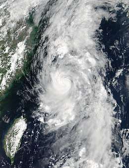 Severe Tropical Storm Nanmadol near peak intensity on July 3 | |
| Formed | July 1, 2017 |
| Dissipated | July 8, 2017 |
| (Extratropical after July 4) | |
| Highest winds |
10-minute sustained: 100 km/h (65 mph) 1-minute sustained: 120 km/h (75 mph) |
| Lowest pressure | 985 hPa (mbar); 29.09 inHg |
| Fatalities | 41 total |
| Damage | $2.04 billion (2017 USD) |
| Areas affected | Japan |
| Part of the 2017 Pacific typhoon season | |
Severe Tropical Storm Nanmadol, known in the Philippines as Severe Tropical Storm Emong, was a tropical cyclone that impacted southern Japan during July 2017. Nanmadol developed over in the Philippine Sea as a tropical depression on July 1, and strengthened into the third named storm of the annual typhoon season during July 3. After gaining organization, the system rapidly developed and intensified into a severe tropical storm and reached its peak intensity with maximum 10-minute sustained winds of 100 km/h (65 mph) and a minimum pressure of 985 hPa (29.09 inHg). On July 4, Nanmadol turned eastwards and made landfall near Nagasaki, Kyushu, just before it transitioned into an extratropical cyclone. Nanmadol's remnant continued to be tracked until it moved out of the basin four days later.
Nanmadol mostly affected the island of Kyushu, bringing torrential rainfall and landslides over in many prefectures; the hardest hit prefectures were Fukuoka and Ōita. The one-day rainfall in Asakura, Fukuoka surpassed the city’s average total for July by 50%, where it saw 500 mm (20 in) fall in a 12-hour period on July 5.[1] Landslides were recorded in 44 different locations and flooding in 38 locations. As of August 5, the death toll has been placed at 36, with five unaccounted for.[2]
The name Nanmadol was contributed to the western Pacific typhoon naming list by Micronesia. It is named after Nan Madol, a famous Pohnpei ruin that is deemed as the "Venice of the Pacific".[3]
Meteorological history
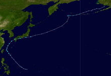
During June 30, a tropical disturbance developed about 463 km (288 mi) to the north-northeast of Palau.[4] Noting some organization within the system, the Joint Typhoon Warning Center (JTWC) issued a Tropical Cyclone Formation Alert (TCFA) early on July 1.[5] Six hours later, the Japan Meteorological Agency (JMA) classified it as a tropical depression.[6][7] Later that day, when the depression's sustained winds were estimated at 55 km/h (35 mph), the JMA began to issue advisories.[8] Shortly after, the Philippine Atmospheric, Geophysical and Astronomical Services Administration (PAGASA) upgraded the system to a tropical depression, assigning the local name Emong.[9]
Early on July 2, the JMA upgraded the system to a tropical storm, and assigned the official name Nanmadol.[10] The PAGASA also upgraded the system to a tropical storm.[11] Soon after, the JTWC gave the system the internal designation of 05W.[12] Satellite imagery depicted convective banding wrapping tightly into Nanmadol's low-level circulation center (LLCC), prompting the JTWC to upgrade it to a tropical storm in their next advisory.[13] Nanmadol later entered a favorable environment with low vertical wind shear, high sea surface temperatures (SSTs) of 30–31 °C (86–88 °F), and robust outflow, allowing it to develop a deep and symmetric core surrounded by deep convection.[14] At this time, the JMA stated that Nanmadol had intensified into a severe tropical storm.[15] The PAGASA also upgraded Nanmadol to a severe tropical storm in their final advisory on the system as it exited the Philippine Area of Responsibility.[16]
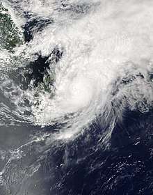
Nanmadol continued to intensify while moving northward just to the east of Taiwan, with satellite imagery capturing a small, developing eye.[17] At 06:00 UTC on July 3, Nanmadol reached its peak intensity with the JTWC assessing the cyclone to have 1-minute sustained winds of 110 km/h (70 mph), just shy of typhoon intensity;[18] the JMA estimated 10-minute sustained winds of 100 km/h (65 mph) and a minimum barometric pressure of 985 hPa (29.09 inHg).[19] Nanmadol maintained its peak intensity for several hours until just before July 4, when the system began curving eastwards and its satellite presentation deteriorated.[20] Around that time, Nanmadol made landfall approximately 40 km (25 mi) to the east of Nagasaki in Kyushu.[21] Despite the system still displaying a well-defined center, cloud tops began to warm, in line with the rapid weakening trend of the system.[22] After several hours, Nanmadol began to interact with the mid-latitude westerlies; the JTWC downgraded the system further to a weak tropical storm, though the JMA still maintained it at severe tropical storm intensity.[23] Conditions became very unfavorable, with high wind shear and cool SSTs of 24–25 °C (75–77 °F).[24] By 21:00 UTC on the same day, the JTWC issued its final advisory on Nanmadol, mentioning that the system was embedded within the cold baroclinic zone, and had thus lost its tropical characteristics and transitioned into a cold-core low.[25] The JMA soon followed suit with their final warning, declaring that Nanmadol had fully become an extratropical cyclone at 00:00 UTC on July 5.[26] Its extratropical remnants later left the basin on July 8.[27]
Preparations, impact, and aftermath
The JMA issued a heavy rain warning for Shimane Prefecture and neighboring areas, in which the government had urged 20,000 residents to evacuate.[28] On July 3, the Sasebo City Emergency Management Bureau activated a total of 30 emergency shelters.[29] The government dispatched a total of 12,000 rescuers, including police officers, firefighters and the Self-Defense Forces troops, in preparation for post-storm relief.[30] On July 10, the Kyushu Railway Company began a bus service to aid residents trapped in some areas along the currently suspended Kyudai Main Line; this included areas between Ukiha Station in Fukuoka Prefecture and Hita Station, Ōita Prefecture, where an iron bridge spanning a river was washed away by floodwaters. Due to the threat of further landslides, the West Nippon Expressway Company extended a closure of the Ōita Expressway.[31] Trees with trunks of 50–60 cm (19.7–23.6 in) were washed away, blocking the water stream further and exacerbating floods. Therefore, on July 11, Forestry Minister Yuji Yamamoto pledged to set up a task force to remove driftwood. Meanwhile, an official at the University of Hyogo warned other municipalities of potential damage caused by fallen trees.[32]
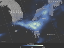
Peak windspeeds of 150 km/h (93 mph) were recorded in Nagasaki upon landfall, including a 162 km/h (101 mph) wind gust in the Shikoku town of Muroto just after 05:30 UTC.[33][34] Strong winds overturned vehicles, collapsed scaffolding, and left 68,500 homes without power in Nagasaki and Kumamoto prefectures; other blackouts occurred in the prefectures of Ōita, Miyazaki and Kagoshima.[34][35] Around 3,000 airline passengers were affected by the grounding and cancellation of at least 47 flights. Heavy rains and strong winds disrupted numerous train services including the iconic Shinkansen, between Hakata and Kagoshima-Chuo in Kyushu.[34][35] Evacuation advisories were issued to at least 20,000 residents due to fears of possible flooding and landslides, especially in the Niigata, Toyama and Nagano prefectures that had experienced rainfall accumulations of up to 300 mm (12 in) in the preceding hours.[35] In Hamada, Shimane, over 80 mm (3.1 in) fell in an hour.[36][28]
At least three people were injured during the storm—a young boy's hand was injured when a school window broke in the city of Kumamoto, and two adults in Ōita prefecture sustained injuries from falls as a result of the strong winds.[35][37] About 180 people took shelter at a junior high school gymnasium in Asakura.[30] Within the prefecture, 130 mm (5.1 in) of rain fell in an hour, greatly contributing to a 24-hour rainfall total of 545 mm (21.5 in).[38] The city of Hita, Ōita also experienced extreme rainfall, with accumulations of 400 mm (16 in).[39] Due to the risk of landslides, an evacuation order which covered 316 people from 115 households was issued in the Haki District of Asakura, due to high risk of landslides. Throughout the Fukuoka and Ōita Prefectures, 1,724 people evacuated.[31] Nearly a week after the flooding had begun, some roads were already reopened over in some communities in the Fukuoka Prefecture.[32] During July 12, the Japanese Prime Minister Shinzō Abe canceled a trip to Estonia for a European tour and instead visited devastated places over in the Kyushu region to view the damage and console residents. He also promised that the government would take action and do everything possible to help rebuild.[40][41]
A total of 41 people have been confirmed dead due to torrential rains which caused landslides and flooding, particularly in Kyushu.[42] Total damage from the storm in Japan were amounted to be JP¥224 billion (US$2.04 billion).[43]
See also
References
- ↑ "Rescuers scramble to find missing after Japan floods". Manila Bulletin. July 7, 2017.
- ↑ "5 still missing, 530 displaced one month after Kyushu's deadly rain". The Borneo Post. August 5, 2017.
- ↑ "List of names for tropical cyclones adopted by the ESCAP/WMO Typhoon Committee for the western North Pacific and the South China Sea". Tokyo, Japan: Japan Meteorological Agency. Archived from the original on 2013-08-31. Retrieved 1 February 2017.
- ↑ "ABPW10 PGTW 300130". Joint Typhoon Warning Center. Archived from the original on July 1, 2017. Retrieved June 30, 2017.
- ↑ "WTPN21 PGTW 010600". Joint Typhoon Warning Center. July 1, 2017. Archived from the original on July 1, 2017.
- ↑ "Marine Weather Warning for GMDSS Metarea XI 2017-07-01T06:00:00Z". WIS Portal – GISC Tokyo. Japan Meteorological Agency. July 1, 2017. Retrieved July 1, 2017.
- ↑ "Tropical Cyclone Formation Alert". Joint Typhoon Warning Center. July 1, 2017. Archived from the original on July 1, 2017. Retrieved July 1, 2017.
- ↑ "TD". Japan Meteorological Agency. Archived from the original on July 3, 2017. Retrieved July 1, 2017.
- ↑ "LPA now Tropical Depression Emong". Philippines: Rappler. PAGASA. Retrieved July 2, 2017.
- ↑ "RSMC Tropical Cyclone Advisory TS 1703 NANMADOL (1703) UPGRADED FROM TD". Japan Meteorological Agency. July 2, 2017. Archived from the original on July 3, 2017.
- ↑ "Tropical depression Emong now a tropical storm". CNN Philippines. July 2, 2017.
- ↑ "Tropical Depression 05W (Nanmadol) Warning Nr 001". Joint Typhoon Warning Center. July 2, 2017. Archived from the original on July 3, 2017.
- ↑ "Prognostic Reasoning for Tropical Storm 05W (Nanmadol) Warning Nr 02". Joint Typhoon Warning Center. July 2, 2017. Archived from the original on July 3, 2017.
- ↑ "Prognostic Reasoning for Tropical Storm 05W (Nanmadol) Warning Nr 03". Joint Typhoon Warning Center. July 2, 2017. Archived from the original on July 3, 2017.
- ↑ "RSMC Tropical Cyclone Advisory STS 1703 NANMADOL (1703) UPGRADED FROM TS". Japan Meteorological Agency. July 2, 2017. Archived from the original on July 3, 2017.
- ↑ "'Emong' exits PAR". Philippines: Philstar. July 3, 2017.
- ↑ "Prognostic Reasoning for Tropical Storm 05W (Nanmadol) Warning Nr 06". Joint Typhoon Warning Center. July 3, 2017. Archived from the original on July 3, 2017.
- ↑ "Tropical Storm 05W (Nanmadol) Warning Nr 006". Joint Typhoon Warning Center. July 3, 2017. Archived from the original on July 3, 2017.
- ↑ "RSMC Tropical Cyclone Advisory STS 1703 NANMADOL (1703)". Japan Meteorological Agency. July 2, 2017. Archived from the original on July 3, 2017.
- ↑ "Prognostic Reasoning for Tropical Storm 05W (Nanmadol) Warning Nr 08". Joint Typhoon Warning Center. July 3, 2017. Archived from the original on July 7, 2017.
- ↑ h"Tropical Cyclone Nanmadol Update (GDACS, JTWC, Media) (ECHO Daily Flash of 4 July 2017)". ReliefWeb. July 4, 2017.
- ↑ "Prognostic Reasoning for Tropical Storm 05W (Nanmadol) Warning Nr 09". Joint Typhoon Warning Center. July 4, 2017. Archived from the original on July 7, 2017.
- ↑ "Prognostic Reasoning for Tropical Storm 05W (Nanmadol) Warning Nr 10". Joint Typhoon Warning Center. July 4, 2017. Archived from the original on July 7, 2017.
- ↑ "Prognostic Reasoning for Tropical Storm 05W (Nanmadol) Warning Nr 11". Joint Typhoon Warning Center. July 4, 2017. Archived from the original on July 7, 2017.
- ↑ "Tropical Depression 05W (Nanmadol) Warning Nr 012". Joint Typhoon Warning Center. July 4, 2017. Archived from the original on July 7, 2017.
- ↑ "RSMC Tropical Cyclone Advisory DEVELOPING LOW FORMER STS 1703 NANMADOL (1703)". Japan Meteorological Agency. July 5, 2017. Archived from the original on July 7, 2017.
- ↑ "Marine Weather Warning for GMDSS Metarea XI 2017-07-08T06:00:00Z". Japan Meteorological Agency. Retrieved July 8, 2017.
- 1 2 "One dead, 20,000 evacuated as tropical storm Nanmadol batters western Japan". Japan: Sun Daily. July 5, 2017.
- ↑ "Tropical Storm 05W (Nanmadol), #9 FINAL: Sasebo all clear". Dave Ornauer. June 30, 2017. Retrieved July 3, 2017.
- 1 2 "Rescuers race against time as flood death toll hits 18". Japan Times. July 8, 2017. Retrieved July 8, 2017.
- 1 2 "Death toll from Kyushu rains hits 22 as searches, evacuations continue". Japan: The Mainichi. July 9, 2017. Retrieved July 10, 2017.
- 1 2 "In Kyushu floods, destruction was magnified by fast-flowing driftwood". The Japan Times. July 12, 2017.
- ↑ "Typhoon hits Nagasaki, torrential rain expected across Japan". Mainichi Daily News. 2017-07-04. Retrieved 2017-07-05.
- 1 2 3 Faith Eherts. "Tropical Storm Nanmadol to batter Japan with wind, rain through midweek". AccuWeather. Retrieved 2017-07-05.
- 1 2 3 4 "Japan typhoon grounds flights, injures 3". The Straits Times. 2017-07-04. Retrieved 2017-07-05.
- ↑ "High temperatures and extreme weather continue". World Meteorological Organization. July 7, 2017. Retrieved July 7, 2017.
- ↑ "Typhoon causes mudslides, blackouts". Japan Today. Retrieved 2017-07-05.
- ↑ "Disaster-hit Kyushu region needs all the help it can get". The Asahi Shimbun. July 8, 2017.
- ↑ "Death toll rises to 18 as rescue operations continue in rain-pummeled southwestern Japan". Xinhua. July 8, 2017.
- ↑ "Japanese PM Abe Promises to Help Victims of Floods; Death Toll up to 25". US News. July 12, 2017.
- ↑ "Japan Abe sees devastation in flood-hit area". Times live. July 12, 2016.
- ↑ "浸水想定区域外14人犠牲 山あいの水流強く". 毎日新聞 (in Japanese). January 11, 2017. Retrieved August 25, 2017.
- ↑ "福岡県被害1941億円 先月調査より744億円増". 毎日新聞 (in Japanese). August 25, 2017. Retrieved August 25, 2017.
External links
| Wikimedia Commons has media related to Tropical Storm Nanmadol (2017). |
- JMA General Information of Severe Tropical Storm Nanmadol (1703) from Digital Typhoon
- JMA Best Track Data of Severe Tropical Storm Nanmadol (1703) (in Japanese)
- 05W.NANMADOL from the U.S. Naval Research Laboratory
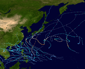
Tropical cyclones of the 2017 Pacific typhoon season | ||||||||||||||||||||||||||||||||||||||||||||||||||||||||||||||||||||||||||||||||||||||
|---|---|---|---|---|---|---|---|---|---|---|---|---|---|---|---|---|---|---|---|---|---|---|---|---|---|---|---|---|---|---|---|---|---|---|---|---|---|---|---|---|---|---|---|---|---|---|---|---|---|---|---|---|---|---|---|---|---|---|---|---|---|---|---|---|---|---|---|---|---|---|---|---|---|---|---|---|---|---|---|---|---|---|---|---|---|---|
 |
| |||||||||||||||||||||||||||||||||||||||||||||||||||||||||||||||||||||||||||||||||||||
| ||||||||||||||||||||||||||||||||||||||||||||||||||||||||||||||||||||||||||||||||||||||