Nan Madol
| Nan Madol | |
|---|---|
 Nan Madol | |
| Location | Temwen Island, Federated States of Micronesia |
| Coordinates | 6°50′31″N 158°19′56″E / 6.84194°N 158.33222°ECoordinates: 6°50′31″N 158°19′56″E / 6.84194°N 158.33222°E |
| Official name: Nan Madol: Ceremonial Centre of Eastern Micronesia | |
| Type | Cultural |
| Criteria | i, iii, iv, vi |
| Designated | 2016 (40th session) |
| Reference no. | 1503 |
| Region | Asia and the Pacific |
| Designated | December 19, 1974 |
| Reference no. | 74002226[1] |
| Designated | September 16, 1985[2] |
 Location of Nan Madol in Federated States of Micronesia | |
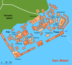
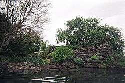
Nan Madol is an archaeological site adjacent to the eastern shore of the island of Pohnpei, now part of the Madolenihmw district of Pohnpei state in the Federated States of Micronesia in the western Pacific Ocean. Nan Madol was the capital of the Saudeleur Dynasty until about 1628.[3][note 1] The city, constructed in a lagoon, consists of a series of small artificial islands linked by a network of canals.[3] The site core with its stone walls encloses an area approximately 1.5 km long by 0.5 km wide and it contains nearly 100 artificial islets—stone and coral fill platforms—bordered by tidal canals.
The name Nan Madol means "spaces between" and is a reference to the canals that crisscross the ruins. The original name was Soun Nan-leng (Reef of Heaven), according to Gene Ashby in his book Pohnpei, An Island Argosy.[9] The ruined city is one of today's great archaeological enigmas and is sometimes called "Atlantis," the "eighth wonder of the world," or the "Venice of the Pacific".[10]
History
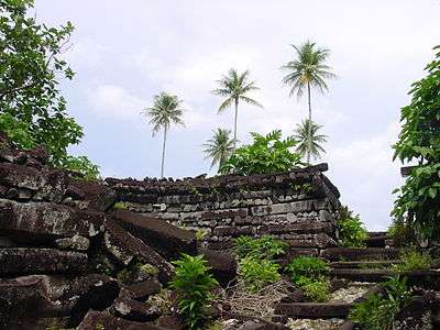
Nan Madol was the ceremonial and political seat of the Saudeleur Dynasty, which united Pohnpei's estimated 25,000 people until about 1628.[3] Set apart between the main island of Pohnpei and Temwen Island, it was a scene of human activity as early as the first or second century AD. By the 8th or 9th century, islet construction had started, with construction of the distinctive megalithic architecture beginning 1180–1200 AD.[11]
Little can be verified about the megalithic construction. Pohnpeian tradition claims that the builders of the Leluh archaeological site on Kosrae (likewise composed of huge stone buildings) migrated to Pohnpei, where they used their skills and experience to build the even more impressive Nan Madol complex. Radiocarbon dating indicates that Nan Madol predates Leluh and it is more likely that Nan Madol influenced Leluh.[11]
According to Pohnpeian legend, Nan Madol was constructed by twin sorcerers Olisihpa and Olosohpa from the mythical Western Katau, or Kanamwayso. The brothers arrived in a large canoe seeking a place to build an altar so that they could worship Nahnisohn Sahpw, the god of agriculture. After several false starts, the two brothers successfully built an altar off Temwen Island, where they performed their rituals. In legend, these brothers levitated the huge stones with the aid of a flying dragon. When Olisihpa died of old age, Olosohpa became the first Saudeleur. Olosohpa married a local woman and sired twelve generations, producing sixteen other Saudeleur rulers of the Dipwilap ("Great") clan.[note 2] The founders of the dynasty ruled kindly, though their successors placed ever increasing demands on their subjects. Their reign ended with the invasion by Isokelekel, who also resided at Nan Madol, though his successors abandoned the site.[7][12][13]
The Polish ethnographer and oceanographer Jan Kubary (1846–1896) made the first detailed description of Nan Madol in 1874.[14]
Purpose and features
The elite centre was a special place of residence for the nobility and of mortuary activities presided over by priests. Its population almost certainly did not exceed 1,000, and may have been less than half that. Although many of the residents were chiefs, the majority were commoners. Nan Madol served, in part, as a way for the ruling Saudeleur chiefs to organize and control potential rivals by requiring them to live in the city rather than in their home districts, where their activities were difficult to monitor.
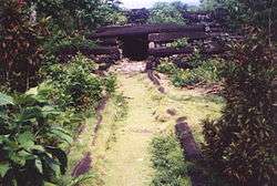
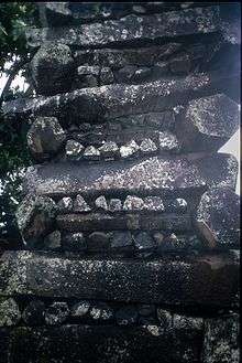
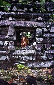
Madol Powe, the mortuary sector, contains 58 islets in the northeastern area of Nan Madol. Most islets were once occupied by the dwellings of priests. Some islets served a special purpose: food preparation, canoe construction on Dapahu, and coconut oil preparation on Peinering. High walls surrounding tombs are located on Peinkitel, Karian, and Lemenkou, but the most prominent is the royal mortuary islet of Nandauwas, where walls 18–25 feet (5.5–7.6 m) high surround a central tomb enclosure within the main courtyard. This was built for the first Saudeleur.[11]
Food and water
On Nan Madol there is no fresh water or food; water must be collected and food grown inland. During Saudeleur rule, Pohnpeians brought essential food and water by boat.[4][6][15] The Saudeleur received food at a particular islet — first Peiniot, and later the closer Usennamw.[6][7]
Around 1628, when Isokelekel overthrew the Saudeleurs and began the Nahnmwarki Era, the Nahnmwarkis lived at Nan Madol, but had to gather their own water and grow their own food. This is thought to have caused them eventually to abandon Nan Madol and move back to their own districts, although there are other explanations for the desertion of the complex, such as a sharp population decline.
Archaeology
Today Nan Madol forms an archaeological district covering more than 18 km² and includes the stone architecture built up on a coral reef flat along the shore of Temwen Island, several other artificial islets, and the adjacent Pohnpei main island coastline. The site core with its stone walls encloses an area approximately 1.5 km long by 0.5 km wide containing nearly 100 artificial islets—stone and coral fill platforms—bordered by tidal canals.
Carbon dating indicates that megalithic construction at Nan Madol began around 1180 AD when large basalt stones were taken from a volcanic plug on the opposite side of Pohnpei. The earliest settlement on Pohnpei was probably around 1 AD although radiocarbon dating only shows human activity starting around 80–200 AD.[11]
In 1985 the ruins of Nan Madol were declared a National Historical Landmark. Currently, a greater effort is being made to preserve them.
Lost continent theories
Nan Madol has been interpreted as the remains of one of the "lost continents" of Lemuria or Mu, although this is today considered falsified by plate tectonics.
- Nan Madol was one of the sites James Churchward identified as being part of the lost continent of Mu, starting in his 1926 book The Lost Continent of Mu Motherland of Man.
- In his book Lost City of Stones (1978), writer Bill S. Ballinger theorizes that the city was built by Greek sailors c. 300 BC.
- David Hatcher Childress, author and publisher, speculates that Nan Madol is connected to the lost continent of Lemuria.[16]
- The 1999 book The Coming Global Superstorm by Art Bell and Whitley Strieber, which predicts that global warming might produce sudden and catastrophic climatic effects, claims that the construction of Nan Madol, with exacting tolerances and extremely heavy basalt materials, necessitated a high degree of technical competency. Since no such society exists in the modern record - or, even, in legend - this society must have been destroyed by dramatic means.
- See also Erich Von Daeniken (1973), The Gold of the Gods, Chapter 4: "Temuen, The Island They Call Nan Madol"
In popular culture
Nan Madol has inspired a number of works of fiction about lost civilizations:
Literature
- The ruins of Nan Madol were used as the setting for a lost race story by A. Merritt, The Moon Pool (1918), in which the islands are called Nan-Tauach and the ruins are called the Nan-Matal.
- Nan Madol and its history have been used as the basis of the novel Deep Fathom (2001) written by James Rollins.
- The ruins of Nan Madol served as the inspiration for the city of R'lyeh in author H.P. Lovecraft's Cthulhu Mythos.
Music
- Nan Madol (1974) is an album recorded by Edward Vesala
- Nan Ma Dol is a song recorded by Endura (band) and released on their Liber Leviathan album (1996).
- Ruins of Nan Madol (2014) is a song recorded by audiomachine
Video Games
- Nan Madol is featured as a cultural city-state in the 2016 video game Civilization VI.
Notes
- ↑ The Saudeleur era lasted around 500 years.[4] Legend generally dates their downfall to the 1500s,[5] however archaeologists date Saudeleur ruins to ca. 1628.[6][7][8]
- ↑ Hanlon (1988) notes differing accounts of the number of Saudeleur rulers, ranging from eight to seventeen, concluding that it is impossible to know this number for certain.[4]:234
References
- ↑ National Park Service (2007-01-23). "National Register Information System". National Register of Historic Places. National Park Service.
- ↑ "Nan Madol". National Historic Landmark summary listing. National Park Service. Archived from the original on 11 May 2011. Retrieved 28 June 2007.
- 1 2 3 Nan Madol, Madolenihmw, Pohnpei William Ayres, Department of Anthropology University Of Oregon, Accessed 26 September 2007
- 1 2 3 Hanlon, David L (1988). Upon a Stone Altar: A History of the Island of Pohnpei to 1890. Pacific Islands Monograph. 5. University of Hawaii Press. pp. 13–25. ISBN 0-8248-1124-0. Retrieved 2012-01-01.
- ↑ Cordy, Ross H (1993). The Lelu Stone Ruins (Kosrae, Micronesia): 1978-81 Historical and Archaeological Research. Asian and Pacific Archaeology. Social Science Research Institute, University of Hawaii at Manoa. pp. 14, 254, 258. ISBN 0-8248-1134-8. Retrieved 2011-12-31.
- 1 2 3 Morgan, William N (1988). Prehistoric Architecture in Micronesia. University of Texas Press. pp. 60, 63, 76, 85. ISBN 0-292-76506-1. Retrieved 2011-12-31.
- 1 2 3 Panholzer, Tom; Rufino, Mauricio (2003). Place Names of Pohnpei Island: Including And (Ant) and Pakin Atolls. Bess Press. pp. xiii, 21, 22, 25, 38, 48, 56, 63, 71. 72, 74, 104. ISBN 1-57306-166-2. Retrieved 2011-12-31.
- ↑ Micronesica. University of Guam. 1990. pp. 92, 203, 277. Retrieved 2011-12-31.
- ↑ Ashby, Gene; 'Pohnpei, An Island Argosy'; Publisher: Rainy Day Pr West; Revised edition (June 1987); ISBN 0-931742-14-5; ISBN 978-0-931742-14-9
- ↑ http://www2.canada.com/vancouvercourier/news/travel/story.html?id=d7601625-fafe-46f4-b1d1-5c18837881cf%5Bpermanent+dead+link%5D
- 1 2 3 4 McCoy, Mark D.; Alderson, Helen A.; Hemi, Richard; Cheng, Hai; Edwards, R. Lawrence (November 2016). "Earliest direct evidence of monument building at the archaeological site of Nan Madol (Pohnpei, Micronesia) identified using 230Th/U coral dating and geochemical sourcing of megalithic architectural stone" (PDF). Quaternary Research. 86 (3): 295–303. doi:10.1016/j.yqres.2016.08.002. Retrieved 30 October 2017.
- ↑ Riesenberg, Saul H (1968). The Native Polity of Ponape. Contributions to Anthropology. 10. Smithsonian Institution Press. pp. 38, 51. Retrieved 2012-01-01.
- ↑ Goodenough, Ward Hunt (2002). Under Heaven's Brow: Pre-Christian Religious Tradition in Chuuk. Memoirs of the American Philosophical Society. 246. American Philosophical Society. p. 293. ISBN 0-87169-246-5. Retrieved 2012-01-01.
- ↑ Rainbird, Paul (2004). The Archaeology of Micronesia. Cambridge University Press. p. 21. ISBN 978 0521651882. Retrieved October 31, 2017.
- ↑ Ballinger, Bill Sanborn (1978). Lost City of Stone: The Story of Nan Madol, the "Atlantis" of the Pacific. Simon and Schuster. pp. 45–8. ISBN 0-671-24030-7. Retrieved 2011-12-31.
- ↑ Lost Cities of Ancient Lemuria & the Pacific, 1991, ISBN 0-932813-04-6
Further reading
- Ayres, William S. Nan Madol, Pohnpei. SAA Bulletin. Vol. 10, Nov. 1992. Society for American Archaeology.
- Ayres, William S. Pohnpei's Position in Eastern Micronesian Prehistory, Micronesica, Supplement 2: Proceedings, Indo Pacific Prehistory Association, Guam, 1990, pp. 187–212.
- Ayres, William S. Mystery Islets of Micronesia. Archaeology Jan-Feb 1990, pp. 58–63.
- Ratzel, Prof. Friedrich The History of Mankind Book II, London 1896. Races of the Pacific and their migrations pp. 159-60. Includes a drawing entitled `Sepulchral monument in Ponapé, Caroline Islands. (From a photograph in the Godeffroy Album.)'
External links
- Nan Madol tourism official site
- Metropolitan Museum of Art
- Archaeologist Felicia Rounds Beardsley on Nan Madol
| Topics | |
|---|---|
| Lists by states |
|
| Lists by insular areas | |
| Lists by associated states | |
| Other areas | |
| |