Mount Carbon, Pennsylvania
| Mount Carbon, Pennsylvania | |
|---|---|
| Borough | |
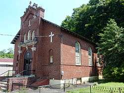 St. Francis De Sales Church on Main St. | |
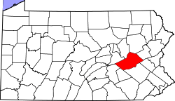
 Location of Mount Carbon in Schuylkill County, Pennsylvania. | |
 Mount Carbon Location in Pennsylvania  Mount Carbon Mount Carbon (the US) | |
| Coordinates: 40°40′21″N 76°11′15″W / 40.67250°N 76.18750°WCoordinates: 40°40′21″N 76°11′15″W / 40.67250°N 76.18750°W | |
| Country | United States |
| State | Pennsylvania |
| County | Schuylkill |
| Settled | 1828 |
| Incorporated | 1864 |
| Government | |
| • Type | Borough Council |
| Area[1] | |
| • Total | 0.07 sq mi (0.18 km2) |
| • Land | 0.07 sq mi (0.18 km2) |
| • Water | 0.00 sq mi (0.00 km2) |
| Population (2010) | |
| • Total | 91 |
| • Estimate (2016)[2] | 89 |
| • Density | 1,289.86/sq mi (498.01/km2) |
| Time zone | UTC-5 (Eastern (EST)) |
| • Summer (DST) | UTC-4 (EDT) |
| ZIP Code | 17901 |
| Area code(s) | 570 |
| FIPS code | 42-51488 |
Mount Carbon is a borough in Schuylkill County, Pennsylvania, two miles south of Pottsville. It was formed from North Manheim Township in 1864. The population was 91 in the 2010 census. The borough is the smallest municipality in Schuylkill County. South Centre Street, Main Street, Sherwood Drive and the Mt. Carbon Arch are the only streets of the borough.
Mount Carbon has also had one of the youngest mayors in history, Mayor Jeffrey Dunkel was sworn in as mayor when he was only 18-years-old.[3] On July 16, 2015 The Pottsville Republican Herald reported that Mayor Dunkel will resign after 13 years for a job opportunity in another state. In February 2016, 22-year-old Brandon Wentz was appointed mayor. Wentz's grandmother was the borough's first female mayor. He died on November 10, 2017 at the age of 23 under mysterious circumstances.[4]
The borough was considering merger with the City of Pottsville. Merger was shot down by the residents and the borough has been making financial progress since new council took the helm.
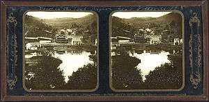
The old Mount Carbon Brewery
It was home for many years to the Mount Carbon Brewery which closed in the late 1970s. D.G. Yuengling & Son bought the rights to use the Mount Carbon (Bavarian) name and label when Mount Carbon Brewery went out of business in 1977. Yuengling initially brewed Mount Carbon for a short time but eventually abandoned it. 7up bottling Co. then took over building for years as a distribution and shipping point.
Transportation
Mount Carbon was the end of the original Philadelphia and Reading Railroad, opened in 1842. Mount Carbon was a very active location along the Canal. The Hotel which was located at the present Pottsville Pizzeria, was rumored to have royalty stay there on their travels.
Geography
Mount Carbon is located at 40°40′21″N 76°11′15″W / 40.67250°N 76.18750°W (40.672364, -76.187494).[5]
According to the United States Census Bureau, the borough has a total area of 0.1 square miles (0.2 km²), all of it land.
Demographics
| Historical population | |||
|---|---|---|---|
| Census | Pop. | %± | |
| 1870 | 364 | — | |
| 1880 | 327 | −10.2% | |
| 1890 | 333 | 1.8% | |
| 1900 | 252 | −24.3% | |
| 1910 | 335 | 32.9% | |
| 1920 | 331 | −1.2% | |
| 1930 | 311 | −6.0% | |
| 1940 | 335 | 7.7% | |
| 1950 | 302 | −9.9% | |
| 1960 | 308 | 2.0% | |
| 1970 | 184 | −40.3% | |
| 1980 | 157 | −14.7% | |
| 1990 | 132 | −15.9% | |
| 2000 | 87 | −34.1% | |
| 2010 | 91 | 4.6% | |
| Est. 2016 | 89 | [2] | −2.2% |
| Sources:[6][7][8] | |||
As of the census[7] of 2000, there were 87 people, 39 households, and 23 families residing in the borough. The population density was 1,414.1 people per square mile (559.8/km²). There were 47 housing units at an average density of 763.9 per square mile (302.4/km²). The racial makeup of the borough was 100.00% White.
There were 39 households out of which 23.1% had children under the age of 18 living with them, 41.0% were married couples living together, 12.8% had a female householder with no husband present, and 41.0% were non-families. 35.9% of all households were made up of individuals and 17.9% had someone living alone who was 65 years of age or older. The average household size was 2.23 and the average family size was 2.87.
In the borough the population was spread out with 19.5% under the age of 18, 8.0% from 18 to 24, 33.3% from 25 to 44, 26.4% from 45 to 64, and 12.6% who were 65 years of age or older. The median age was 40 years. For every 100 females there were 102.3 males. For every 100 females age 18 and over, there were 100.0 males.
The median income for a household in the borough was $34,688, and the median income for a family was $46,875. Males had a median income of $24,000 versus $23,125 for females. The per capita income for the borough was $18,355. There were no families and 7.1% of the population living below the poverty line, including no under eighteens and 40.0% of those over 64.
Gallery
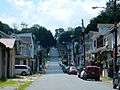 Main St. in Mount Carbon.
 Residence on Main St.
 GoodFella's Cafe on Mt. Carbon Arch St.
 Mount Carbon Fire Station.
 Historic Firrefighter truck.
References
- ↑ "2016 U.S. Gazetteer Files". United States Census Bureau. Retrieved Aug 14, 2017.
- 1 2 "Population and Housing Unit Estimates". Retrieved June 9, 2017.
- ↑ "Go-getter," 18, ousts mayor in Michigan, by Wendy Koch, USA TODAY, November 9, 2005
- ↑ https://www.rawstory.com/2017/11/young-mayor-of-small-pennsylvania-town-mysterious-dies/
- ↑ "US Gazetteer files: 2010, 2000, and 1990". United States Census Bureau. 2011-02-12. Retrieved 2011-04-23.
- ↑ "Census of Population and Housing". U.S. Census Bureau. Retrieved 11 December 2013.
- 1 2 "American FactFinder". United States Census Bureau. Retrieved 2008-01-31.
- ↑ "Incorporated Places and Minor Civil Divisions Datasets: Subcounty Resident Population Estimates: April 1, 2010 to July 1, 2012". Population Estimates. U.S. Census Bureau. Archived from the original on 17 June 2013. Retrieved 11 December 2013.
| Wikimedia Commons has media related to Mount Carbon, Pennsylvania. |